Map of Lake Providence town
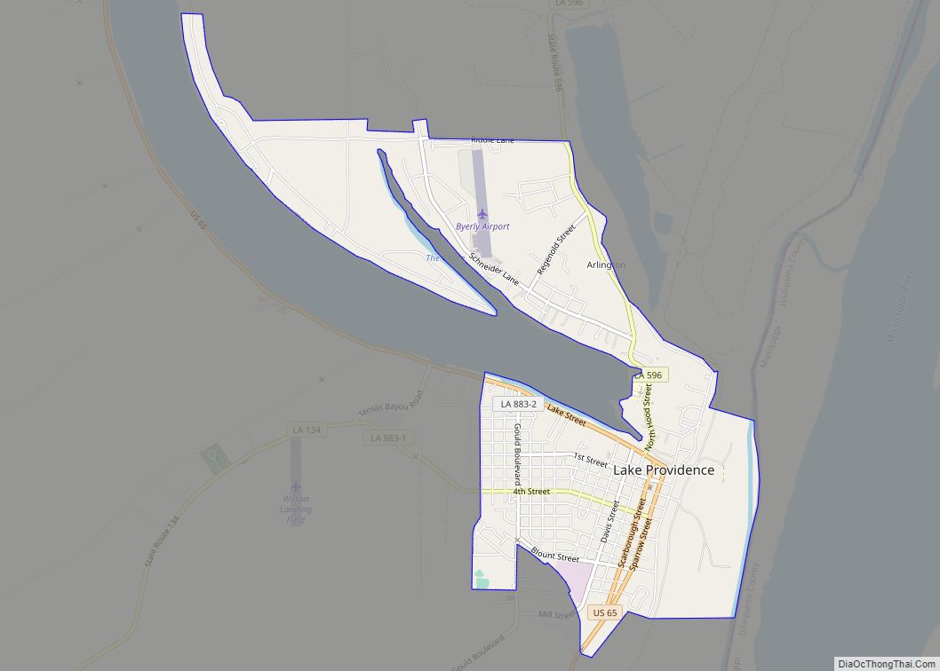
Lake Providence is a town in, and the parish seat of, East Carroll Parish in northeastern Louisiana. The population was 5,104 at the 2000 census and declined by 21.8 percent to 3,991 in 2010. The town’s poverty rate is approximately 55 percent; the average median household income is $16,500, and the average age is 31. ... Read more
Map of Lake Providence town
Map of Laplace CDP, Louisiana
LaPlace (/ləˈplɑːs/ lə-PLAHSS) is a census-designated place (CDP) in St. John the Baptist Parish, Louisiana, United States, situated along the east bank of the Mississippi River, in the New Orleans metropolitan area. In 2020, it had a population of 28,841. LaPlace is the southern terminus of Interstate 55, where it joins with Interstate 10, and ... Read more
Map of Laplace CDP, Louisiana
Map of Lakeview CDP, Louisiana
Lakeview is an unincorporated community and census-designated place (CDP) in Caddo Parish, Louisiana, United States. As of the 2010 census it had a population of 948. It is located on the north shore of Cross Lake 5 miles (8 km) northwest of downtown Shreveport. It is bordered by the city limits of Shreveport to the north, ... Read more
Map of Lakeview CDP, Louisiana
Map of Lakeshore CDP
Lakeshore is an unincorporated community and census-designated place in Ouachita Parish, Louisiana, United States. Its population was 1,930 as of the 2010 census. The community is located on the south bank of Bayou Desiard, east of Monroe. Lakeshore CDP overview: Name: Lakeshore CDP LSAD Code: 57 LSAD Description: CDP (suffix) State: Louisiana County: Ouachita Parish ... Read more
Map of Lakeshore CDP
Map of Lecompte town
Lecompte (/ləˈkaʊnt/ lə-KOWNT) is a town in Rapides Parish, Louisiana, United States. Lecompte is situated along the banks of the Red River in central Louisiana. US Highway 71, Louisiana’s major north-south route which connects Baton Rouge and Shreveport, runs through Lecompte. Lecompte is named after a horse called LeComte, which was named after horse breeder ... Read more
Map of Lecompte town
Map of Lawtell CDP
Lawtell is an unincorporated community and census-designated place in St. Landry Parish, Louisiana, United States. The name is a portmanteau of the names of its two founders: Lawler and Littell. State Representative Dustin Miller is a native of and a businessman in Lawtell. Lawtell CDP overview: Name: Lawtell CDP LSAD Code: 57 LSAD Description: CDP ... Read more
Map of Lawtell CDP
Map of Larose CDP
Larose is an unincorporated community and census-designated place (CDP) in Lafourche Parish, Louisiana, United States. The population was 6,763 in 2020. It is part of the Houma–Bayou Cane–Thibodaux metropolitan statistical area. Larose CDP overview: Name: Larose CDP LSAD Code: 57 LSAD Description: CDP (suffix) State: Louisiana County: Lafourche Parish Elevation: 8 ft (2 m) Total Area: 11.17 sq mi ... Read more
Map of Larose CDP
Map of Leonville town
Leonville is a town in St. Landry Parish, Louisiana, United States. The population was 1,084 at the 2010 census. It is part of the Opelousas–Eunice Micropolitan Statistical Area. Leonville town overview: Name: Leonville town LSAD Code: 43 LSAD Description: town (suffix) State: Louisiana County: St. Landry Parish Elevation: 30 ft (9 m) Total Area: 2.76 sq mi (7.15 km²) Land ... Read more
Map of Leonville town
Map of Lemannville CDP
Lemannville is an unincorporated community and census-designated place in Ascension and St. James parishes, Louisiana, United States. Per the 2020 census, the population was 695. Lemannville CDP overview: Name: Lemannville CDP LSAD Code: 57 LSAD Description: CDP (suffix) State: Louisiana County: Ascension Parish, St. James Parish Elevation: 21 ft (6 m) Total Area: 1.27 sq mi (3.30 km²) Land Area: ... Read more
Map of Lemannville CDP
Map of Leesville city, Louisiana
Leesville is a city in, and the parish seat of, Vernon Parish, Louisiana, United States. The population was 5,649 at the 2020 census. It is part of the Fort Polk South micropolitan area and is additionally served by the Leesville Airport. The city is home to the Fort Polk U.S. Army installation. Leesville city overview: ... Read more
Map of Leesville city, Louisiana
Map of Livingston town, Louisiana
Livingston is the parish seat of Livingston Parish, Louisiana, United States. The population was 1,769 at the 2010 census. Livingston hosts one of the two LIGO gravitational wave detector sites, the other one being located in Hanford, Washington. Livingston town overview: Name: Livingston town LSAD Code: 43 LSAD Description: town (suffix) State: Louisiana County: Livingston ... Read more
Map of Livingston town, Louisiana
Map of Lisbon village, Louisiana
Lisbon is a village in Claiborne Parish, Louisiana, United States. The population was 185 at the 2010 census. Lisbon is located east of the parish seat of Homer. Lisbon should not be confused with the village of Lisbon in Calcasieu Parish, Louisiana, which later evolved first into Bagdad and later into the city of Westlake. ... Read more
Map of Lisbon village, Louisiana