South Portland is a city in Cumberland County, Maine, United States, and is the fourth-largest city in the state, incorporated in 1898. At the 2020 census, the city population was 26,498. Known for its working waterfront, South Portland is situated on Portland Harbor and overlooks the skyline of Portland and the islands of Casco Bay. Due to South Portland’s close proximity to air, marine, rail, and highway transportation options, the city has become a center for retail and industry in the region.
Despite the name, South Portland was never part of the city of Portland, but rather part of Cape Elizabeth. It broke off in 1895. However, both Cape Elizabeth and Portland were once part of Falmouth. Cape Elizabeth, then including what later became South Portland, broke away from Falmouth in 1765. South Portland is a principal city of the Portland–South Portland–Biddeford metropolitan area.
| Name: | South Portland city |
|---|---|
| LSAD Code: | 25 |
| LSAD Description: | city (suffix) |
| State: | Maine |
| County: | Cumberland County |
| Elevation: | 23 ft (7 m) |
| Total Area: | 14.01 sq mi (36.29 km²) |
| Land Area: | 12.04 sq mi (31.19 km²) |
| Water Area: | 1.97 sq mi (5.10 km²) |
| Total Population: | 26,498 |
| Population Density: | 2,200.10/sq mi (849.49/km²) |
| Area code: | 207 |
| FIPS code: | 2371990 |
| GNISfeature ID: | 0575893 |
| Website: | www.southportland.org |
Online Interactive Map
Click on ![]() to view map in "full screen" mode.
to view map in "full screen" mode.
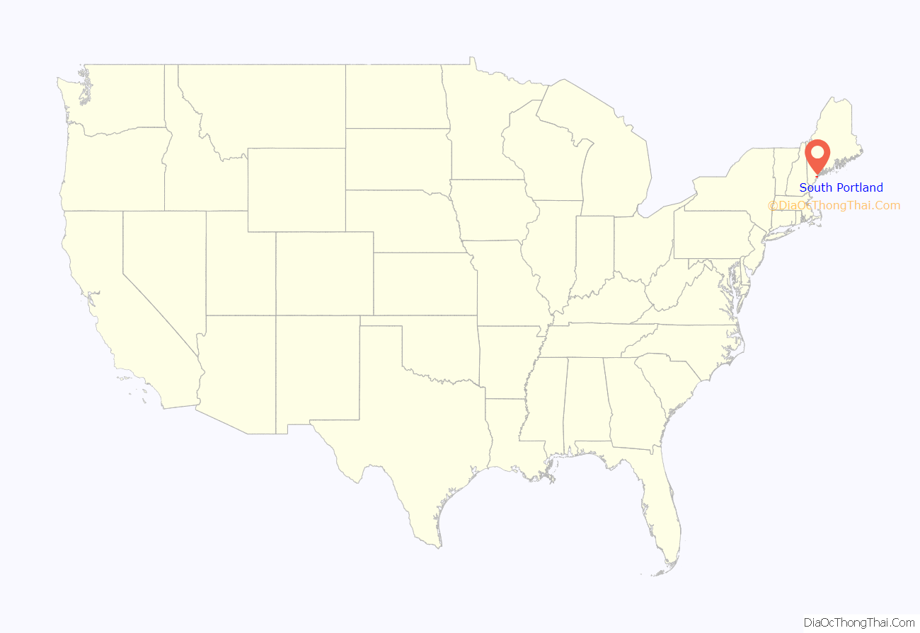
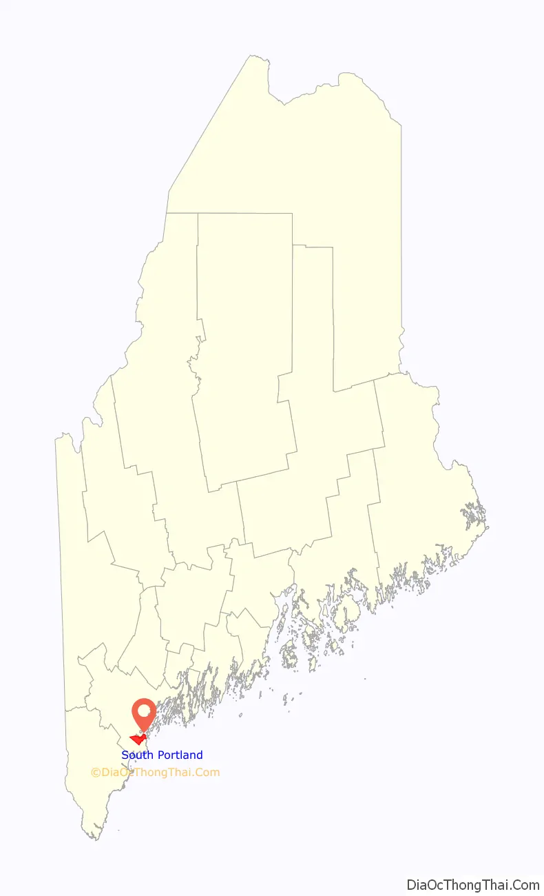
South Portland location map. Where is South Portland city?
History
South Portland was first colonized in 1630, and it grew to become a small residential community with many farms. The village was raided by natives in Father Rale’s War (1724). In 1858, the City of Portland purchased land near the Fore River for the Forest City Cemetery. On March 15, 1895, it was incorporated as a town after it broke away from Cape Elizabeth, based on a disagreement on a future source of public drinking water. Three years later South Portland became a city, destined to receive its drinking water, like Portland, from Sebago Lake, while Cape Elizabeth used wells or other local sources.
On South Portland’s waterfront is Fort Preble, which is a military fort established in 1808 to protect Portland Harbor. It was in operation during several American conflicts, including the United States Civil War, World War I, and World War II. Near Fort Preble is Spring Point Ledge Light, which was constructed by the federal government in 1897 to mark a dangerous rock ledge.
In December 1844, Portland resident Ellen G. White, who became a founder of the Seventh-day Adventist church, is said to have experienced her first vision during a prayer meeting at the home of Mrs. Haines at 60 Ocean Street, which later became the Griffin Club. The building was torn down in 2018.
In 1940, the Todd-Bath Iron Shipbuilding Corp (later called the “East Yard”) was established to build cargo ships for Britain. When the United States became involved with World War II, the shipyard expanded to include the South Portland Shipbuilding Corp. (aka the “West Yard”), that later combined with the Todd-Bath yard to become the New England Shipbuilding Corporation. These shipyards built 236 of the 440 foot (134 m) long Liberty ships, more than 10 percent of all the Liberty ships constructed during the war years. At its peak, the shipyard employed some 30,000 people, including thousands of women, who took over the jobs vacated by men going into the service. The shipyard gradually ceased operations after the war ended in 1945. Remnants of the shipyards are visible, and there is a memorial to the shipyard and the workers at Bug Light Park. The park is also home to Portland Breakwater Lighthouse, commonly referred to as “Bug Light”.
On July 11, 1944, at 4:45 p.m., U.S. Army Lt. Phillip “Phee” Russell was attempting to land his Douglas A-26 Invader at the Portland-Westbrook Municipal Airport. For reasons that were never fully determined, Russell lost control of the plane and crashed into a trailer park in South Portland’s Brick Hill neighborhood. Nineteen people were killed and 20 people were injured—mostly the families of South Portland shipyard workers—making it the worst aviation accident in Maine history. A Long Creek Air Tragedy Memorial was eventually erected to commemorate the crash and honor the victims, but not until 66 years later.
Over the last few decades, South Portland has become the retail capital of Maine. The Mill Creek shopping center, built in the 1950s, was the first such “strip mall” built in Maine: a line of stores under one long roof and a covered walkway. Mill Creek has changed and grown significantly since, but the original layout still forms the core of the stores. The area in Mill Creek known as the Waterfront Market sits at the base of the Casco Bay Bridge and attracts shoppers from Scarborough, Cape Elizabeth and Portland.
The need for a large mall in Maine emerged in the 1960s, as Portland’s downtown district could not accommodate the growing retail market. A former pig farm in South Portland was chosen as the site for the project because it was close to I-95 and convenient from Portland. Beginning construction of the Maine Mall in the late 1960s marked the start of a major transition in the western part of South Portland: from a rural, agrarian landscape to the large retail center that exists today.
The oldest neighborhood in South Portland, and its former “retail corridor”, is Ferry Village. Prior to the Casco Bay Bridge (or the one it replaced, the Million Dollar Bridge), ferries transported people and goods back and forth across the harbor to Portland. The landscape and the makeup of residents in Ferry Village were forever changed upon the close of the WWII shipyards. The Village has slowly bounced back and is now one of the more popular places in the city to live.
Ferry Village also has one of the most active and involved neighborhood associations in Southern Maine. The Ferry Village Neighborhood Conservation Association (FVNCA) was formed in August 1985 to address the development boom in the 1980s which was quickly altering the character of the waterfront and many Greater Portland neighborhoods. FVNCA was instrumental in the formation of the South Portland Land Trust as well as the City-managed Land Bank which provides seed money for the acquisition of available open space.
After decades of neglect, the westernmost neighborhoods of South Portland, including Redbank and Brick Hill, experienced new growth and revitalization in 2006 with the redevelopment of the former Maine Youth Center site as a mixed-use neighborhood featuring affordable housing, market rate housing, professional offices and outdoor recreational spaces. The redevelopment of the Brick Hill site spurred additional private development nearby in the form of market rate housing, retail and light industry. The city’s 2017 West End Master Plan aims to further encourage such development in that area of the city.
South Portland was voted one of the best places to live in Maine in 2018.
South Portland Road Map
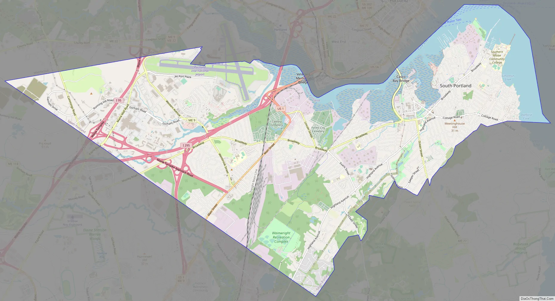
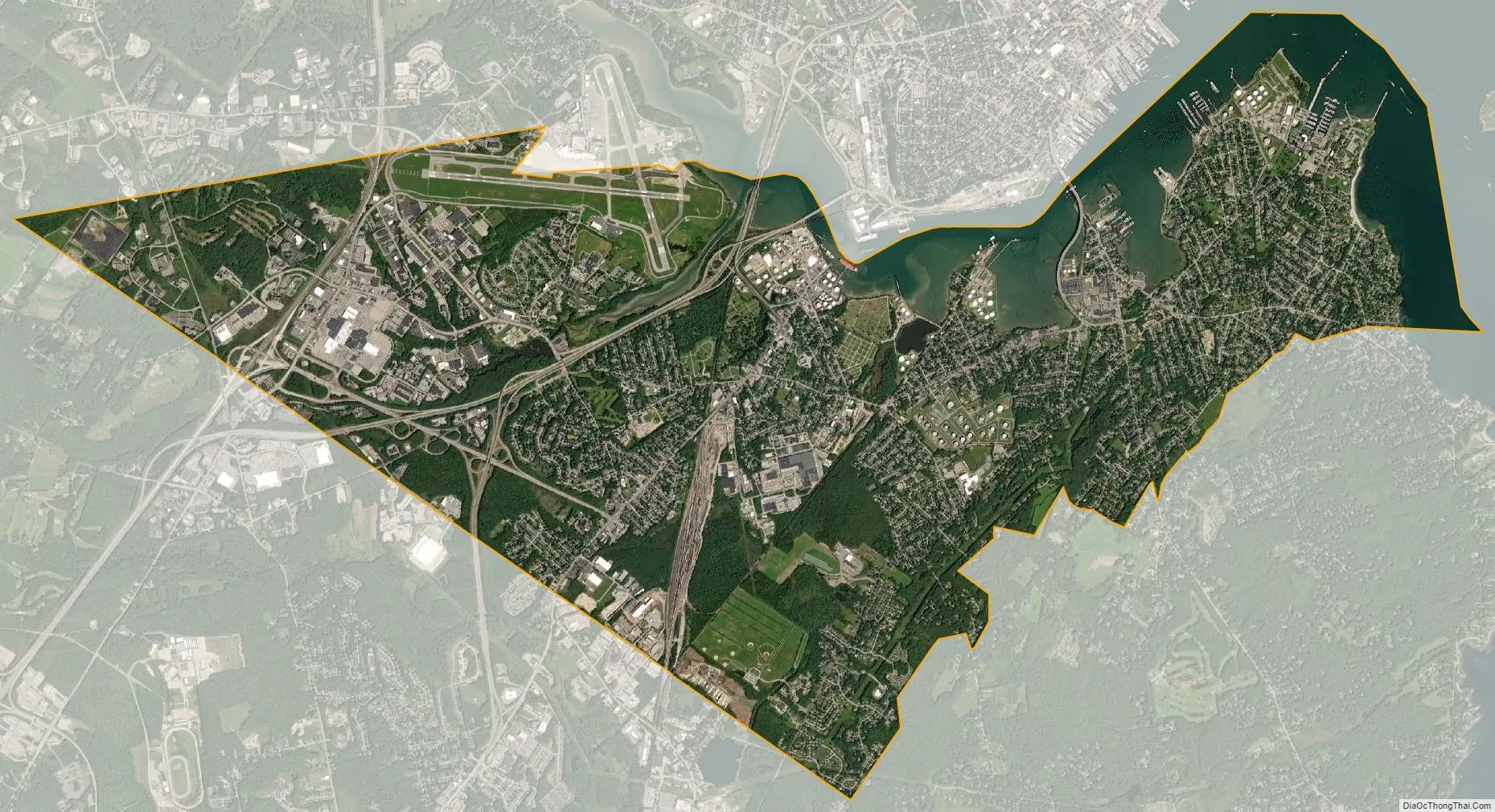
South Portland city Satellite Map
Geography
South Portland is bordered by Portland to the north, Cape Elizabeth and Scarborough to the south, and Westbrook to the west. The city is located at 43°37′54″N 70°16′22″W / 43.63167°N 70.27278°W / 43.63167; -70.27278. According to the United States Census Bureau, the city has a total area of 14.02 square miles (36.31 km), of which 11.99 square miles (31.05 km) is land and 2.03 square miles (5.26 km) is water. The city-owned South Portland Bus Service provides public transportation throughout the city.
Villages and neighborhoods
As defined by the city’s Planning Department in a 2018 neighborhood map, South Portland comprises the following districts that could be described in some cases as urban or suburban villages, listed below in bold; historic neighborhoods are in italics.
- Ferry Village
- Cushing’s Point
- Knightville
- Mill Creek
- Ligonia
- Pleasantdale
- Highland Avenue / Stanwood Park
- Skunk Hill
- Brick Hill
- Cash Corner
- Country Gardens
- The Maine Mall
- Meadowbrook
- Redbank
- Sunset Park
- Thornton Heights
- Town House Corner
- South Portland Heights
- Willard
- Loveitt’s Field
- Meetinghouse Hill
- Willard Beach
See also
Map of Maine State and its subdivision: Map of other states:- Alabama
- Alaska
- Arizona
- Arkansas
- California
- Colorado
- Connecticut
- Delaware
- District of Columbia
- Florida
- Georgia
- Hawaii
- Idaho
- Illinois
- Indiana
- Iowa
- Kansas
- Kentucky
- Louisiana
- Maine
- Maryland
- Massachusetts
- Michigan
- Minnesota
- Mississippi
- Missouri
- Montana
- Nebraska
- Nevada
- New Hampshire
- New Jersey
- New Mexico
- New York
- North Carolina
- North Dakota
- Ohio
- Oklahoma
- Oregon
- Pennsylvania
- Rhode Island
- South Carolina
- South Dakota
- Tennessee
- Texas
- Utah
- Vermont
- Virginia
- Washington
- West Virginia
- Wisconsin
- Wyoming