Map of Franklin CDP, Maryland

Map of Franklin CDP, Maryland

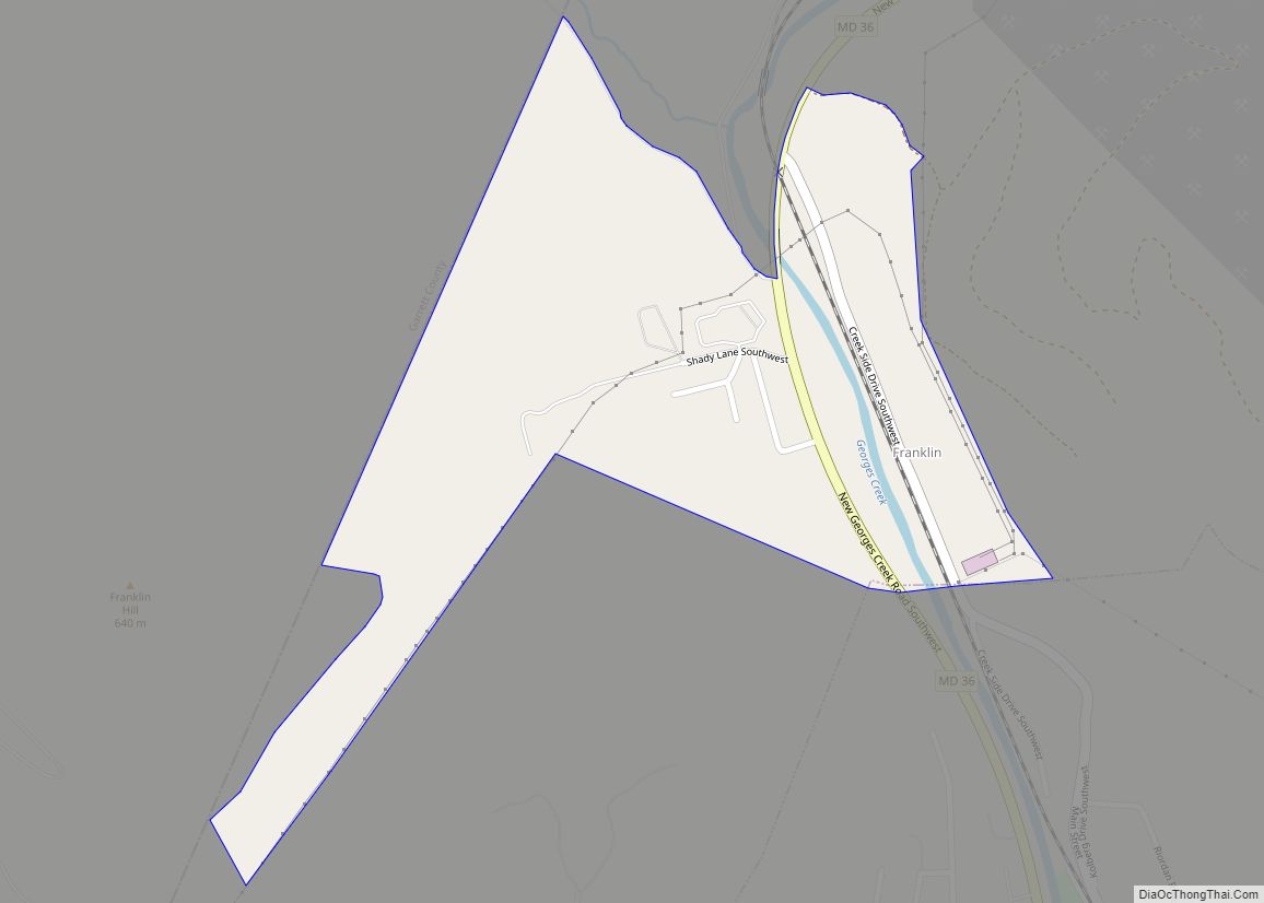
Franklin is an unincorporated community and census-designated place (CDP) in Allegany County, Maryland, United States. As of the 2010 census it had a population of 290. Franklin is located along Maryland routes 36 and 937, 1 mile (1.6 km) north of Westernport. Franklin CDP overview: Name: Franklin CDP LSAD Code: 57 LSAD Description: CDP (suffix) State: … Read more

Map of Four Corners CDP, Maryland

Map of Four Corners CDP, Maryland

Four Corners is a neighborhood and census-designated place (CDP) in Montgomery County, Maryland, United States. Many residents consider the neighborhood a part of Silver Spring, to whose CDP it belonged until 2010. It had a population of 8,316 at the 2020 census. Four Corners CDP overview: Name: Four Corners CDP LSAD Code: 57 LSAD Description: … Read more

Map of Fountainhead-Orchard Hills CDP

Map of Fountainhead-Orchard Hills CDP

Fountainhead-Orchard Hills is a census-designated place (CDP) in Washington County, Maryland, United States. The population was 3,861 at the 2000 census. Fountainhead-Orchard Hills CDP overview: Name: Fountainhead-Orchard Hills CDP LSAD Code: 57 LSAD Description: CDP (suffix) State: Maryland County: Washington County Total Area: 4.42 sq mi (11.44 km²) Land Area: 4.42 sq mi (11.44 km²) Water Area: 0.00 sq mi (0.00 km²) Total Population: … Read more

Map of Friendly CDP

Map of Friendly CDP, Maryland

Friendly is an unincorporated area and census-designated place (CDP) in Prince George’s County, Maryland, United States, with an African-American majority population, located a few miles south of Washington, D.C. The population was 9,937 at the 2020 census. Friendly had its own rural post office in the early 20th century, and is now under the mailing … Read more

Map of Frenchtown-Rumbly CDP

Map of Frenchtown-Rumbly CDP

Frenchtown-Rumbly is a census-designated place in Somerset County, Maryland, United States. The population was 96 at the 2000 census. It is included in the Salisbury, Maryland-Delaware Metropolitan Statistical Area. Frenchtown-Rumbly CDP overview: Name: Frenchtown-Rumbly CDP LSAD Code: 57 LSAD Description: CDP (suffix) State: Maryland County: Somerset County Total Area: 8.39 sq mi (21.74 km²) Land Area: 3.76 sq mi (9.73 km²) … Read more

Map of Frederick city, Maryland

Map of Frederick city, Maryland

Frederick is a city in and the county seat of Frederick County, Maryland, United States. It is located at an important crossroads at the intersection of a major north–south Native American trail and east–west routes to the Chesapeake Bay, both at Baltimore and what became Washington, D.C. and across the Appalachian mountains to the Ohio … Read more

Map of Friendship CDP, Maryland

Map of Friendship CDP, Maryland

Friendship is an unincorporated community and census-designated place (CDP) in Anne Arundel County, Maryland, United States. As of the 2010 census, its population was 447. Friendship covers 1.794 square miles (2.887 km), and is located at the southern tip of Anne Arundel County along Maryland Route 2, by which road it is 22 miles (35 km) north … Read more

Map of Friendship Heights Village CDP

Map of Friendship Heights Village CDP

Friendship Heights Village is an urbanized, unincorporated area in Montgomery County, Maryland, United States. Friendship Heights Village is distinct from the Washington, D.C., neighborhood of Friendship Heights). The population was 5,360 at the 2020 census. Friendship Heights Village CDP overview: Name: Friendship Heights Village CDP LSAD Code: 57 LSAD Description: CDP (suffix) State: Maryland County: … Read more

Map of Friendsville town

Map of Friendsville town, Maryland

Friendsville is a town in Garrett County, Maryland, United States. The population was 491 at the 2010 census. Friendsville town overview: Name: Friendsville town LSAD Code: 43 LSAD Description: town (suffix) State: Maryland County: Garrett County Incorporated: 1902 Elevation: 1,499 ft (457 m) Total Area: 1.00 sq mi (2.59 km²) Land Area: 1.00 sq mi (2.59 km²) Water Area: 0.00 sq mi (0.00 km²) Total Population: … Read more

Map of Fulton CDP, Maryland

Map of Fulton CDP, Maryland

Fulton is a census-designated place located in southern Howard County, Maryland, United States. As of the 2010 census it had a population of 2,049. Fulton CDP overview: Name: Fulton CDP LSAD Code: 57 LSAD Description: CDP (suffix) State: Maryland County: Howard County Elevation: 453 ft (138 m) Total Area: 3.79 sq mi (9.83 km²) Land Area: 3.79 sq mi (9.81 km²) Water Area: … Read more

Map of Fruitland city, Maryland

Map of Fruitland city, Maryland

Fruitland is a city in Wicomico County, Maryland, United States. The population was 4,866 at the 2010 census. It is included in the Salisbury, Maryland-Delaware Metropolitan Statistical Area. Fruitland city overview: Name: Fruitland city LSAD Code: 25 LSAD Description: city (suffix) State: Maryland County: Wicomico County Incorporated: 1947 Elevation: 36 ft (11 m) Total Area: 3.86 sq mi (10.00 km²) … Read more

Map of Frostburg city

Map of Frostburg city

Frostburg is a city in Allegany County, Maryland. It is located at the head of the Georges Creek Valley, 8 miles (13 km) west of Cumberland. The town is one of the first cities on the “National Road”, US 40, and the western terminus of the Western Maryland Scenic Railroad. It is part of the Cumberland … Read more