Frederick is a city in and the county seat of Frederick County, Maryland, United States. It is located at an important crossroads at the intersection of a major north–south Native American trail and east–west routes to the Chesapeake Bay, both at Baltimore and what became Washington, D.C. and across the Appalachian mountains to the Ohio River watershed. Frederick’s population was 78,171 people as of the 2020 census, making it the second-largest incorporated city in Maryland behind Baltimore. It is a part of the Washington metropolitan area, which is part of a greater Washington–Baltimore combined statistical area.
Frederick is home to Frederick Municipal Airport (IATA: FDK), which accommodates general aviation, and Fort Detrick, a U.S. Army bioscience and communications research installation and Frederick County’s largest employer.
| Name: | Frederick city |
|---|---|
| LSAD Code: | 25 |
| LSAD Description: | city (suffix) |
| State: | Maryland |
| County: | Frederick County |
| Founded: | 1745 |
| Elevation: | 302 ft (92 m) |
| Land Area: | 23.85 sq mi (61.76 km²) |
| Water Area: | 0.10 sq mi (0.26 km²) |
| Population Density: | 3,264.33/sq mi (1,260.35/km²) |
| FIPS code: | 2430325 |
| GNISfeature ID: | 0584497 |
| Website: | www.cityoffrederickmd.gov |
Online Interactive Map
Click on ![]() to view map in "full screen" mode.
to view map in "full screen" mode.
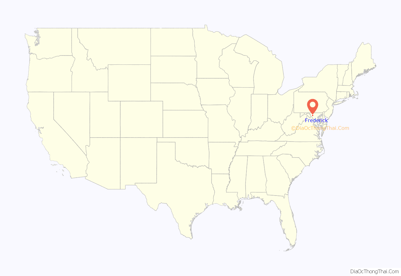
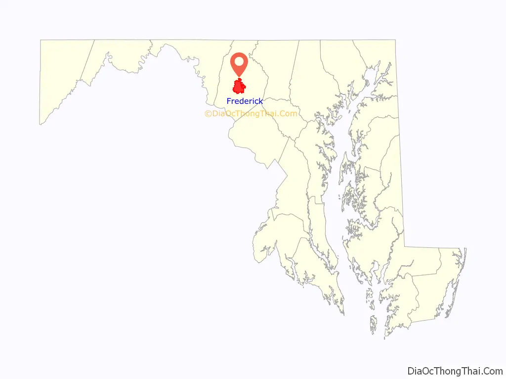
Frederick location map. Where is Frederick city?
History
Pre-Colonization
Located where Catoctin Mountain (the easternmost ridge of the Blue Ridge mountains) meets the rolling hills of the Piedmont region, the Frederick area became a crossroads even before European explorers and traders arrived. Native American hunters (possibly including the Susquehannocks, the Algonquian-speaking Shawnee, or the Seneca or Tuscarora or other members of the Iroquois Confederation) followed the Monocacy River from the Susquehanna River watershed in Pennsylvania to the Potomac River watershed and the lands of the more agrarian and maritime Algonquian peoples, particularly the Lenape of the Delaware valley or the Piscataway and Powhatan of the lower Potomac watershed and Chesapeake Bay. This became known as the Monocacy Trail or even the Great Indian Warpath, with some travelers continuing southward through the “Great Appalachian Valley” (Shenandoah Valley, etc.) to the western Piedmont in North Carolina, or traveling down other watersheds in Virginia toward the Chesapeake Bay, such as those of the Rappahannock, James and York Rivers.
Colonial era
The earliest European settlement was slightly north of Frederick in Monocacy, Maryland. Monocacy was founded before 1730 (when the Indian trail became a wagon road) and was abandoned before the American Revolutionary War, likely due to the river’s periodic flooding, hostilities predating the French and Indian War, or simply Frederick’s better location with easier access to the Potomac River near its confluence with the Monocacy.
Daniel Dulany, a land speculator, laid out what was initially called Frederick Town by 1745. Three years earlier, All Saints Church had been founded on a hilltop near a warehouse/trading post. Sources disagree as to which Frederick the town was named for, but the likeliest candidates are Frederick Calvert, 6th Baron Baltimore (one of the proprietors of Maryland), Frederick Louis, Prince of Wales, and Frederick the Great, King of Prussia.
In 1748, Frederick County was formed by carving a section off of Prince George’s County. Frederick Town (now Frederick) was made the county seat of Frederick County. The county originally extended to the Appalachian mountains (areas further west being disputed between the colonies of Virginia and Pennsylvania until 1789). The current town’s first house was built by a young German Reformed schoolmaster from the Rhineland Palatinate named[Johann Thomas Schley (died 1790), who led a party of immigrants (including his wife, Maria Von Winz) to the Maryland colony. The Palatinate settlers bought land from Dulany on the banks of Carroll Creek, and Schley’s house stood at the northwest corner of Middle Alley and East Patrick Street into the 20th century. Schley’s settlers also founded a German Reformed Church (today known as Evangelical Reformed Church, and part of the UCC). Probably the oldest house still standing in Frederick today is Schifferstadt, built in 1756 by German settler Joseph Brunner and now the Schifferstadt Architectural Museum.
Schley’s group was among the many Pennsylvania Dutch (ethnic Germans) (as well as Scots-Irish and French and later Irish) who migrated south and westward in the late-18th century. Frederick was an important stop along the migration route that became known as the Great Wagon Road, which came down from Gettysburg, Pennsylvania and Emmitsburg, Maryland and continued south following the Great Appalachian Valley through Winchester and Roanoke, Virginia. Another important route continued along the Potomac River from near Frederick, to Hagerstown, where it split. One branch crossed the Potomac River near Martinsburg, West Virginia and continued down into the Shenandoah valley. The other continued west to Cumberland, Maryland and ultimately crossed the Appalachian Mountains into the watershed of the Ohio River. Thus, British General Edward Braddock marched his troops (including the youthful George Washington) west in 1755 through Frederick on the way to their fateful ambush near Fort Duquesne (later Fort Pitt, then Pittsburgh) during the French and Indian War. However, the British after the Proclamation of 1763 restricted that westward migration route until after the American Revolutionary War. Other westward migrants continued south from Frederick to Roanoke along the Great Wagon Road, crossing the Appalachians into Kentucky and Tennessee at the Cumberland Gap near the Virginia/North Carolina border.
Other German settlers in Frederick were Evangelical Lutherans, led by Rev. Henry Muhlenberg. They moved their mission church from Monocacy to what became a large complex a few blocks further down Church Street from the Anglicans and the German Reformed Church. Methodist missionary Robert Strawbridge, who accepted an invitation to preach at Frederick town in 1770, and Francis Asbury, who arrived two years later, both helped found a congregation which became Calvary Methodist Church, worshipping in a log building from 1792 (although superseded by larger buildings in 1841, 1865, 1910 and 1930). Frederick also had a Catholic mission, to which Rev. Jean DuBois was assigned in 1792, which became St. John the Evangelist Church (built in 1800).
To control this crossroads during the American Revolution, the British garrisoned a German Hessian regiment in the town; the war (the stone, L-shaped “Hessian Barracks” still stand).
Early 19th century
As the county seat for Western Maryland, Frederick not only was an important market town but also the seat of justice. Although Montgomery County and Washington County were split off from Frederick County in 1776, Frederick remained the seat of the smaller (though still large) county. Important lawyers who practiced in Frederick included John Hanson, Francis Scott Key and Roger B. Taney.
Frederick was also known during the nineteenth century for its religious pluralism, with one of its main thoroughfares, Church Street, hosting about a half dozen major churches. In 1793, All Saints Church hosted the first confirmation of an American citizen, by the newly consecrated Episcopal Bishop Thomas Claggett. That original colonial building was replaced in 1814 by a brick classical revival structure. It still stands today, although the principal worship space has become an even larger brick gothic church joining it at the back and facing Frederick’s City Hall (so the parish remains the oldest Episcopal Church in western Maryland). The main Catholic church, dedicated to St. John the Evangelist, was built in 1800, then rebuilt in 1837 (across the street) one block north of Church Street on East Second Street, where it still stands along with a school and convent established by the Visitation Sisters. The stone Evangelical Lutheran Church of 1752 was also rebuilt and enlarged in 1825, then replaced by the current twin-spired structure in 1852.
The oldest African-American church in the town is Asbury United Methodist Church, founded as the Old Hill Church, a mixed congregation in 1818. It became an African-American congregation in 1864, renamed Asbury Methodist Episcopal Church in 1870, and built its current building on All Saints Street in 1921.
Together, these churches dominated the town, set against the backdrop of the first ridge of the Appalachians at Catoctin Mountain. The abolitionist poet John Greenleaf Whittier later immortalized this view of Frederick in his poem to “Barbara Fritchie”: “The clustered spires of Frederick stand/Green-walled by the hills of Maryland.”
When U.S. President Thomas Jefferson commissioned National Road from Baltimore toward St. Louis, eventually built to Vandalia, then the state capital of Illinois, National Pike ran through Frederick along Patrick Street; it later became U.S. Route 40. Frederick’s Jacob Engelbrecht corresponded with Jefferson in 1824 and received a transcribed psalm from Jefferson in return. Engelbrecht kept a diary from 1819 through 1878, which remains an important first-hand account of 19th century life on National Road. An important house remaining from this era is the Tyler Spite House, built in 1814 at 112 W. Church Street by a local doctor to prevent the city from extending Record Street south through his land to meet West Patrick Street.
Frederick also became one of the new nation’s leading mining counties in the early 19th century. It exported gold, copper, limestone, marble, iron, and other minerals. As early as the American Revolution, Catoctin Furnace near Thurmont became an important source of iron production. Other mining areas split off into Washington County, Maryland and Allegheny County, Maryland but continued to ship their ore through Frederick to Eastern cities and ports.
Frederick had easy access to the Chesapeake and Ohio Canal, which began operations in 1831 and continued hauling freight until 1924. Also in 1831, the Baltimore and Ohio Railroad (B&O) completed its Frederick Branch line from the Frederick (or Monocacy) Junction off the main Western Line from Baltimore to Harpers Ferry, Cumberland, and the Ohio River. The railroad reached Chicago and St. Louis by the 1850s.
Civil War
Frederick became Maryland’s capital city briefly in 1861, as the legislature moved from Annapolis to vote on the secession question. President Lincoln arrested several members, and the assembly was unable to convene a quorum to vote on secession.
As a major crossroads, Frederick, like Winchester, Virginia, and Martinsburg, West Virginia, saw considerable action during the American Civil War. Slaves also escaped from or through Frederick (since Maryland was still a “slave state” although it had not seceded) to join the Union forces, work against the Confederacy and seek freedom. During the Maryland campaigns, both Union and Confederate troops marched through the city. Frederick also hosted several hospitals to nurse the wounded from those battles, as is related in the National Museum of Civil War Medicine on East Patrick Street.
A legend related by John Greenleaf Whittier claimed that Frederick’s Pennsylvania Dutch women (including Barbara Fritchie who reportedly waved a flag) booed the Confederates in September 1862, as General Stonewall Jackson led his light infantry division through Frederick on his way to the battles of Crampton’s, Fox’s and Turner’s Gaps on South Mountain and Antietam near Sharpsburg. Union Major General Jesse L. Reno’s IX Corps followed Jackson’s men through the city a few days later on the way to the Battle of South Mountain, where Reno died. The sites of the battles are due west of the city along the National Road, west of Burkittsville. Confederate troops under Jackson and Walker unsuccessfully attempted to halt the Federal army’s westward advance into the Cumberland Valley and towards Sharpsburg. Gathland State Park has the War Correspondents’ Memorial stone arch erected by reporter/editor George Alfred Townsend (1841–1914). The 1889 memorial commemorating Major General Reno and the Union soldiers of his IX Corps is on Reno Monument Road west of Middletown, just below the summit of Fox’s Gap, as is a 1993 memorial to slain Confederate Brig. Gen. Samuel Garland Jr., and the North Carolina troops who held the line.
President Abraham Lincoln, on his way to visit Gen. George McClellan after the Battle of South Mountain and the Battle of Antietam, delivered a short speech at what was then the B. & O. Railroad depot at the current intersection of East All Saints and South Market Streets. A plaque commemorates the speech (at what is today the Frederick Community Action Agency, a Social Services office).
At the Prospect Hall mansion off Jefferson Street to Buckeystown Pike near what is now Butterfly Lane, in the early morning hours of June 28, 1863, a messenger arrived from President Abraham Lincoln and General-in-Chief Henry Halleck, informing General George Meade that he would be replacing General Joseph Hooker after the latter’s disastrous performance at Chancellorsville in May. The Army of the Potomac camped around the Prospect Hall property for the several days as skirmishers pursued Lee’s Confederate Army of Northern Virginia prior to Gettysburg. A large granite rectangular monument made from one of the boulders at the “Devil’s Den” in Gettysburg to the east along the driveway commemorates the midnight change-of-command.
In July 1864, in the third Southern invasion, Confederate troops led by Lieutenant General Jubal Early occupied Frederick and extorted $200,000 ($3.47 million in 2021 dollars) from citizens for not razing the city on their way to Washington D.C. Union troops under Major General Lew Wallace fought a successful delaying action, in what became the last significant Confederate advance at the Battle of Monocacy, also known as the “Battle that saved Washington.” The Monocacy National Battlefield lies just southeast of the city limits, along the Monocacy River at the B. & O. Railroad junction where two bridges cross the stream – an iron-truss bridge for the railroad and a covered wooden bridge for the Frederick-Urbana-Georgetown Pike, which was the site of the main battle of July 1864. Some skirmishing occurred further northeast of town at the stone-arched “Jug Bridge” where the National Road crossed the Monocacy; and an artillery bombardment occurred along the National Road west of town near Red Man’s Hill and Prospect Hall mansion as the Union troops retreated eastward. Antietam National Battlefield and South Mountain State Battlefield Park which commemorates the 1862 battles are located 23 miles and 35 miles respectively to the west-northwest. While Gettysburg National Battlefield of 1863 lies approximately 35 miles (56 km) to the north-northeast.
The reconstructed home of Barbara Fritchie stands on West Patrick Street, just past Carroll Creek linear park. Fritchie, a significant figure in Maryland history in her own right, is buried in Frederick’s Mount Olivet Cemetery. British Prime Minister Winston Churchill quoted Whittier’s poem to President Franklin D. Roosevelt when they stopped here in 1941 on a car trip to the presidential retreat, then called “Shangra-La” (now “Camp David”) within the Catoctin Mountains near Thurmont.
Late 19th century
Admiral Winfield Scott Schley (1839–1911) was born at “Richfields”, the mansion home of his father. He became an important naval commander of the American fleet on board his flagship and heavy cruiser USS Brooklyn along with Admiral William T. Sampson in the Battle of Santiago de Cuba off the shores of the Spanish island colony of Cuba in the Spanish–American War in 1898. Major Henry Schley’s son, Dr. Fairfax Schley, was instrumental in setting up the Frederick County Agricultural Society and the Great Frederick Fair. Gilmer Schley served as Mayor from 1919 to 1922, and the Schleys remained one of the town’s leading families into the late-20th century.
Nathaniel Wilson Schley, a prominent banker, and his wife Mary Margaret Schley helped organize and raise funds for the annual Great Frederick Fair, one of the two largest agricultural fairs in the State. Since the 1960s, the fair has featured many outstanding country-western singers and become a major music festival. Schley Avenue commemorates the family’s role in the city’s heritage.
The Frederick and Pennsylvania Line railroad ran from Frederick to the Pennsylvania–Maryland State line, a/k/a Mason–Dixon line. Chartered in 1867, construction began in 1869 and the line opened October 8, 1872. However, it defaulted on its interest payments in 1874 and acquired by the Pennsylvania Railroad in 1875, which formed a new division to operate the rail line. In the spring of 1896, the Frederick and Pennsylvania Line railroad was liquidated in a judicial sale to the Pennsylvania Railroad for $150,000. The railroad survived through mergers and the Penn-Central bankruptcy. However, the State of Maryland acquired the Frederick and Pennsylvania Line in 1982. As of 2013, all but two miles (3.2 km) at the southern terminus at Frederick still exist, operated by either the Walkersville Southern, or the Maryland Midland Railway (MMID) railroads.
Jewish pioneers Henry Lazarus and Levy Cohan settled in Frederick in the 1740s as merchants. Mostly German Jewish immigrants organized a community in the mid-19th century, creating the Frederick Hebrew Congregation in 1858. Later the congregation lapsed, but was reorganized in 1917 as a cooperative effort between the older settlers and more recently arrived Eastern European Jews under the name Beth Sholom Congregation.
In 1905, Rev. E. B. Hatcher started the First Baptist Church of Frederick.
After the Civil War, the Maryland legislature established racially segregated public facilities by the end of the 19th century, re-imposing white supremacy. Black institutions were typically underfunded in the state, and it was not until 1921 that Frederick established a public high school for African Americans. First located at 170 West All Saints Street, it moved to 250 Madison Street, where it eventually was adapted as South Frederick Elementary. The building presently houses the Lincoln Elementary School. The Laboring Sons Memorial Grounds, a cemetery for free blacks, was founded in 1851.
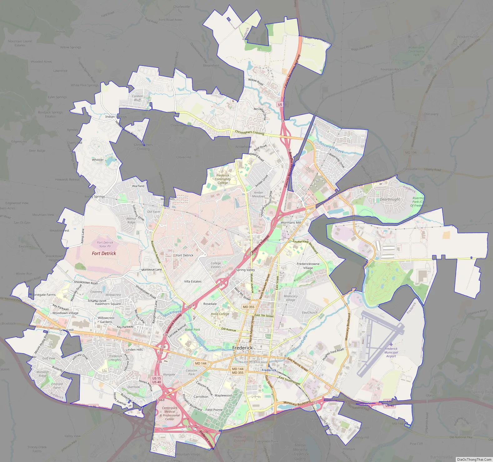
Frederick Road Map
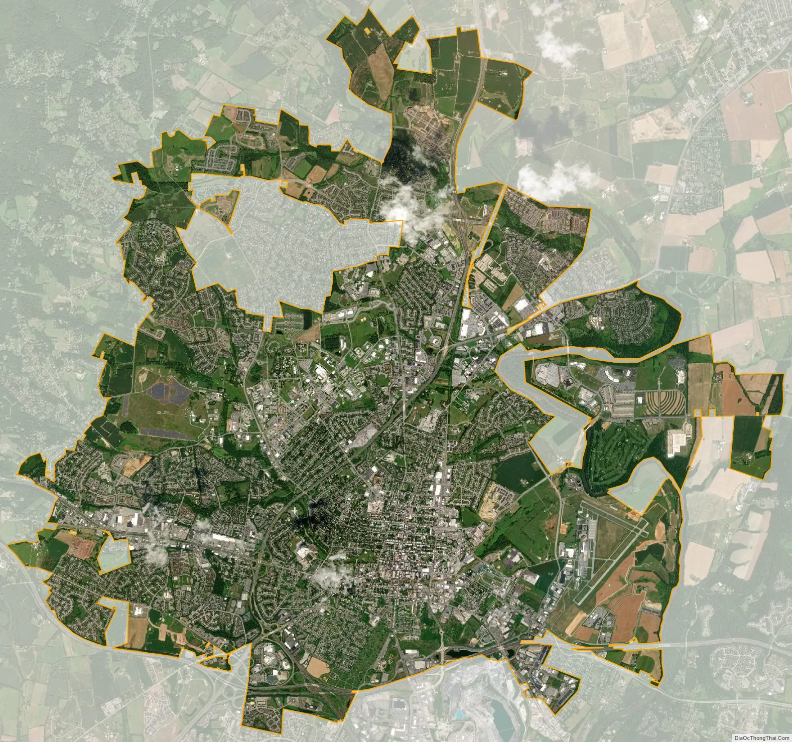
Frederick city Satellite Map
Geography
Frederick is located in Frederick County in the northern part of the state of Maryland. The city has served as a major crossroads since colonial times. Today it is located at the junction of Interstate 70, Interstate 270, U.S. Route 340, U.S. Route 40, U.S. Route 40 Alternate and U.S. Route 15 (which runs north–south). In relation to nearby cities, Frederick lies 46 miles (74 km) west of Baltimore, 50 miles (80 km) north and slightly west of Washington, D.C., 24 miles (39 km) southeast of Hagerstown and 71 miles (114 km) southwest of Harrisburg, Pennsylvania. The city’s coordinates are 39°25’35” North, 77°25’13” West (39.426294, −77.420403).
According to the U.S. Census Bureau, the city has a total area of 23.96 square miles (62.06 km), of which 23.79 square miles (61.62 km) is land and 0.18 square miles (0.47 km) is water. The city’s area is predominantly land, with small areas of water being the Monocacy River, which runs to the east of the city, Carroll Creek (which runs through the city and causes periodic floods, such as that during the summer of 1972 and fall of 1976), as well as several neighborhood ponds and small city owned lakes, such as Culler Lake, a man-made small body of water in the downtown area.
Climate
The climate in this area is characterized by hot, humid summers and generally cool winters. It lies to the west of the fall line, which gives the city slightly lower temperatures compared to locales further east. According to the Köppen Climate Classification system, Frederick has a humid subtropical climate, abbreviated Cfa on climate maps. Frederick is also the site of the highest temperature recorded in Maryland at 109 °F (42.8 °C) on July 10, 1936.
See also
Map of Maryland State and its subdivision: Map of other states:- Alabama
- Alaska
- Arizona
- Arkansas
- California
- Colorado
- Connecticut
- Delaware
- District of Columbia
- Florida
- Georgia
- Hawaii
- Idaho
- Illinois
- Indiana
- Iowa
- Kansas
- Kentucky
- Louisiana
- Maine
- Maryland
- Massachusetts
- Michigan
- Minnesota
- Mississippi
- Missouri
- Montana
- Nebraska
- Nevada
- New Hampshire
- New Jersey
- New Mexico
- New York
- North Carolina
- North Dakota
- Ohio
- Oklahoma
- Oregon
- Pennsylvania
- Rhode Island
- South Carolina
- South Dakota
- Tennessee
- Texas
- Utah
- Vermont
- Virginia
- Washington
- West Virginia
- Wisconsin
- Wyoming


