Map of Highland Beach town, Maryland

Map of Highland Beach town, Maryland

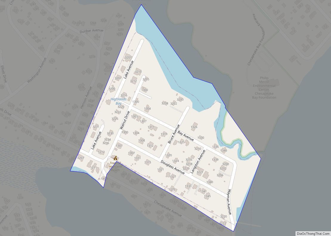
Highland Beach is a town in Anne Arundel County, Maryland, United States. Per the 2020 census, the population was 118. The town was founded late in the 19th century by affluent African Americans from Washington, D.C. and Baltimore, looking for a summer retreat on the Chesapeake Bay. The town’s incorporated status gave it a unique … Read more

Map of Highfield-Cascade CDP

Map of Highfield-Cascade CDP

Highfield-Cascade is a census-designated place (CDP) in Washington County, Maryland, United States. The CDP encompasses two closely-spaced unincorporated communities, Highfield and Cascade, which are usually referred to separately. The population of the combined CDP was 1,141 at the 2000 census. Highfield-Cascade CDP overview: Name: Highfield-Cascade CDP LSAD Code: 57 LSAD Description: CDP (suffix) State: Maryland … Read more

Map of Herald Harbor CDP

Map of Herald Harbor CDP

Herald Harbor is a census-designated place and an unincorporated community in Anne Arundel County, Maryland, United States. As of the 2010 census, the population was 2,603. It is a quiet residential area with a scenic view of the Severn River and is near the community of Crownsville and Interstate 97. Herald Harbor is known for … Read more

Map of Hillcrest Heights CDP, Maryland

Map of Hillcrest Heights CDP, Maryland

Hillcrest Heights is an unincorporated area and census-designated place (CDP) in Prince George’s County, Maryland, United States. The population was 15,793 at the 2020 census. For mailing address purposes, it is part of the smaller community of Temple Hills and is also near Suitland. Hillcrest Heights CDP overview: Name: Hillcrest Heights CDP LSAD Code: 57 … Read more

Map of Hillandale CDP

Map of Hillandale CDP

Hillandale is an unincorporated area and census-designated place located in Montgomery and Prince George’s counties, Maryland, United States. As of the 2020 census, it had a population of 5,774. Hillandale is contained between the Prince George’s / Montgomery County line to the east, the Anacostia River to the west, McCeney Avenue to the north, and … Read more

Map of Highland CDP, Maryland

Map of Highland CDP, Maryland

Highland is an unincorporated community and census-designated place in Howard County, Maryland, United States. As of the 2020 census it had a population of 1,133. It uses the 20777 zip code. Highland CDP overview: Name: Highland CDP LSAD Code: 57 LSAD Description: CDP (suffix) State: Maryland County: Howard County Elevation: 520 ft (160 m) Total Area: 2.42 sq mi … Read more

Map of Huntingtown CDP

Map of Huntingtown CDP

Huntingtown, established 1683, is a census-designated place (CDP) in Calvert County, Maryland, United States. The population was 3,311 at the 2010 census, up from 2,436 in 2000. Many large estate homes have recently been built in small developments off routes 2/4. It has a public high school called Huntingtown High. The Calverton School is located … Read more

Map of Hughesville CDP

Map of Hughesville CDP, Maryland

Hughesville is a census-designated place (CDP) in Charles County, Maryland, United States. The population was 2,197 at the 2010 census. Truman’s Place was listed on the National Register of Historic Places in 1988. Hughesville CDP overview: Name: Hughesville CDP LSAD Code: 57 LSAD Description: CDP (suffix) State: Maryland County: Charles County Elevation: 180 ft (55 m) Total … Read more

Map of Hillsboro town, Maryland

Map of Hillsboro town, Maryland

Hillsboro is a town in Caroline County, Maryland, United States. The population was 161 at the 2010 United States Census. Daffin House and St. Paul’s Episcopal Church were listed on the National Register of Historic Places in 1975. Hillsboro town overview: Name: Hillsboro town LSAD Code: 43 LSAD Description: town (suffix) State: Maryland County: Caroline … Read more

Map of Hyattsville city

Map of Hyattsville city

Hyattsville is a city in Prince George’s County, Maryland, United States, and also a close, urban suburb of Washington, D.C. The population was 21,187 at the 2020 United States Census. Hyattsville city overview: Name: Hyattsville city LSAD Code: 25 LSAD Description: city (suffix) State: Maryland County: Prince George’s County Incorporated: 1886 Elevation: 105 ft (32 m) Total … Read more

Map of Hutton CDP

Map of Hutton CDP

Hutton is an unincorporated community and census-designated place (CDP) in Garrett County, Maryland, United States. Variant names for Hutton include Huttons Switch Station and Kindness. The population was 86 at the 2010 census, which was up from a population of 29 recorded in the 2000 census. Hutton is located on Maryland Route 39 adjacent to … Read more

Map of Hurlock town

Map of Hurlock town

Hurlock is a town in Dorchester County, Maryland, United States. The population was 2,092 at the 2010 census. Hurlock town overview: Name: Hurlock town LSAD Code: 43 LSAD Description: town (suffix) State: Maryland County: Dorchester County Incorporated: 1892 Elevation: 39 ft (12 m) Total Area: 2.89 sq mi (7.48 km²) Land Area: 2.67 sq mi (6.91 km²) Water Area: 0.22 sq mi (0.57 km²) Total Population: … Read more