Map of Chestertown town

Map of Chestertown town, Maryland

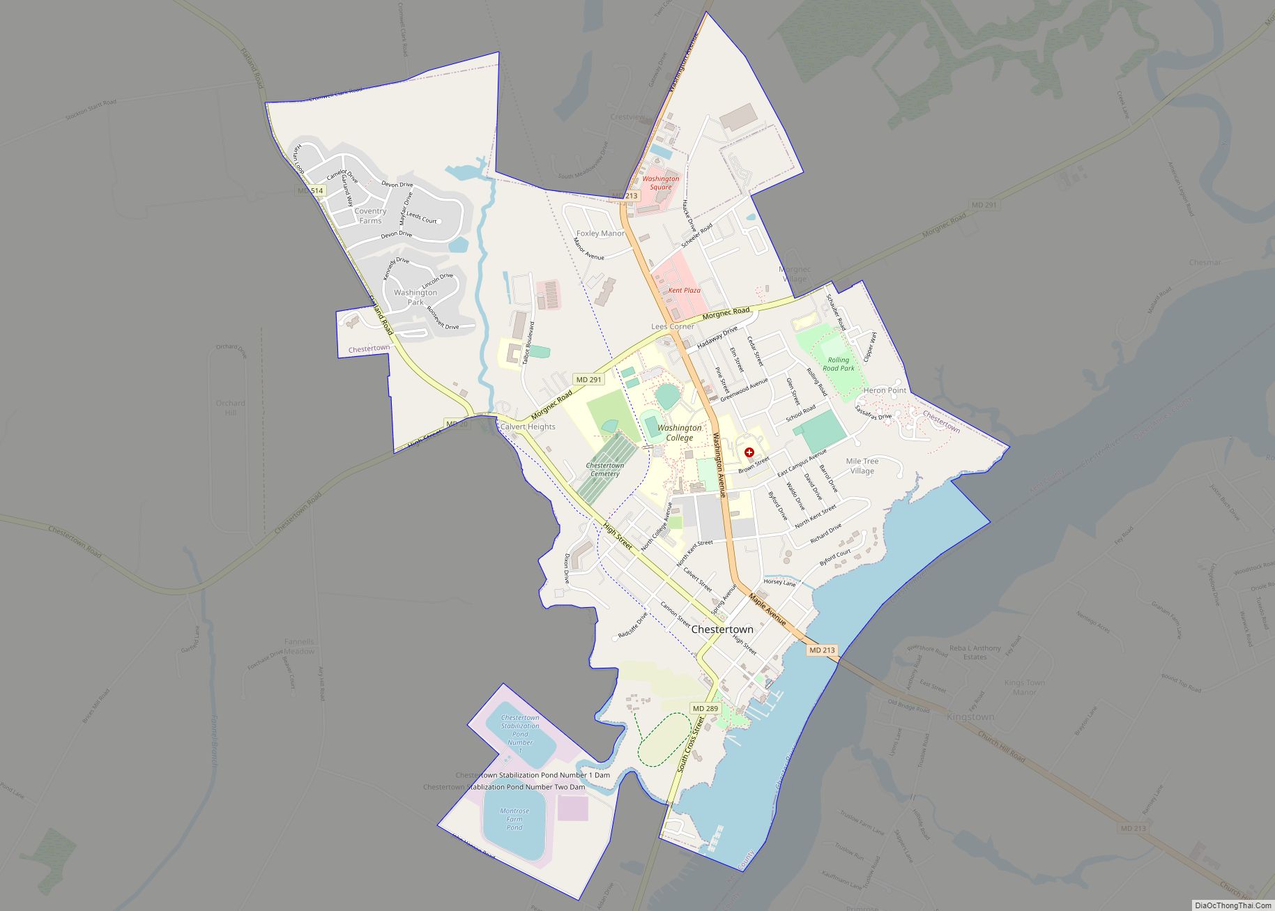
Chestertown is a town in Kent County, Maryland. The population was 5,252 as of the 2010 census. It is the county seat of Kent County. Chestertown town overview: Name: Chestertown town LSAD Code: 43 LSAD Description: town (suffix) State: Maryland County: Kent County Incorporated: 1805 Elevation: 20 ft (6 m) Total Area: 3.29 sq mi (8.51 km²) Land Area: 2.92 sq mi … Read more

Map of Chester CDP, Maryland

Map of Chester CDP, Maryland

Chester is a census-designated place on Kent Island in Queen Anne’s County, Maryland, United States. The population was 3,723 at the 2000 census. Chester CDP overview: Name: Chester CDP LSAD Code: 57 LSAD Description: CDP (suffix) State: Maryland County: Queen Anne’s County Elevation: 7 ft (2 m) Total Area: 6.98 sq mi (18.09 km²) Land Area: 5.24 sq mi (13.56 km²) Water Area: … Read more

Map of Chesapeake Ranch Estates CDP

Map of Chesapeake Ranch Estates CDP

The Chesapeake Ranch Estates (CRE), also known locally as the Ranch Club, is located in Lusby, Maryland, United States, in southern Calvert County. CRE was founded in 1958 and is governed by a homeowners’ association, which is officially called the “Property Owner’s Association of the Chesapeake Ranch Estates” (POACRE). Today, CRE is composed of over … Read more

Map of Cheverly town

Map of Cheverly town

Cheverly is a town in Prince George’s County, Maryland, United States, located very close to Washington, D.C., though not bordering it directly. The town was founded in 1918 and incorporated in 1931. Per the 2020 census, the population was 6,170. Cheverly borders the communities of Tuxedo, Chapel Oaks, Landover, Landover Hills, Villa Heights, and Bladensburg. … Read more

Map of Chevy Chase Section Three village

Map of Chevy Chase Section Three village

Chevy Chase Section Three is a village in Montgomery County, Maryland. It was organized as a Special Tax District in 1916 and incorporated as a village in 1982. The population was 760 at the 2010 census. It is part of a larger community, colloquially referred to as Chevy Chase, that includes several adjoining settlements in … Read more

Map of Chevy Chase Section Five village

Map of Chevy Chase Section Five village

Chevy Chase Section Five is an incorporated village in Montgomery County, Maryland, United States. The population was 672 at the 2020 census. It is part of a larger community, colloquially referred to as Chevy Chase, that includes several adjoining settlements in Montgomery County and one neighborhood of Washington, D.C. Chevy Chase Section Five village overview: … Read more

Map of Chevy Chase CDP

Map of Chevy Chase CDP

Chevy Chase (/ˈtʃɛviː tʃeɪs/) is a census-designated place (CDP) in Montgomery County, Maryland, United States. The population was 10,176 at the 2020 census. Chevy Chase CDP overview: Name: Chevy Chase CDP LSAD Code: 57 LSAD Description: CDP (suffix) State: Maryland County: Montgomery County Elevation: 361 ft (110 m) Total Area: 2.42 sq mi (6.26 km²) Land Area: 2.41 sq mi (6.25 km²) Water … Read more

Map of Chevy Chase Village town

Map of Chevy Chase Village town

Chevy Chase Village, Maryland is an incorporated municipality in Montgomery County, Maryland, United States, bordering Washington, D.C. It is made up of sections 1, 1a, and 2 of Chevy Chase, as originally designated by The Chevy Chase Land Company. The population was 1,953 as of the 2010 census. The town is the wealthiest in Maryland, … Read more

Map of Chevy Chase View town

Map of Chevy Chase View town

Chevy Chase View is a town located in Montgomery County, Maryland, United States. Established as a Special Tax District in 1924, the town was formally incorporated on October 28, 1993. The population was 920 at the 2010 census. Chevy Chase View town overview: Name: Chevy Chase View town LSAD Code: 43 LSAD Description: town (suffix) … Read more

Map of Choptank CDP

Map of Choptank CDP

Choptank is an unincorporated town and census-designated place on the Eastern Shore of Maryland, in Caroline County, Maryland, United States. As of the 2010 census it had a population of 129. The town was founded in the 17th century. It is located on the tidal Choptank River, which flows into Chesapeake Bay. Tradition has it … Read more

Map of Chillum CDP

Map of Chillum CDP

Chillum is an unincorporated area and census-designated place in Prince George’s County, Maryland, United States, bordering Washington, D.C. and Montgomery County. In addition to being its own unincorporated neighborhood, Chillum is also a census-designated place covering a larger area than the Chillum neighborhood. As of the 2010 census, the Chillum CDP included Chillum, as well … Read more

Map of Chewsville CDP

Map of Chewsville CDP

Chewsville is a census-designated place (CDP) in Washington County, Maryland, United States. The population was 293 at the 2000 census. Chewsville CDP overview: Name: Chewsville CDP LSAD Code: 57 LSAD Description: CDP (suffix) State: Maryland County: Washington County Elevation: 636 ft (194 m) Total Area: 0.83 sq mi (2.16 km²) Land Area: 0.83 sq mi (2.16 km²) Water Area: 0.00 sq mi (0.00 km²) Total Population: … Read more