Chillum is an unincorporated area and census-designated place in Prince George’s County, Maryland, United States, bordering Washington, D.C. and Montgomery County.
In addition to being its own unincorporated neighborhood, Chillum is also a census-designated place covering a larger area than the Chillum neighborhood. As of the 2010 census, the Chillum CDP included Chillum, as well as the adjacent unincorporated communities of Avondale, Carole Highlands, Green Meadows, and Lewisdale. The population was 36,039 at the 2020 census.
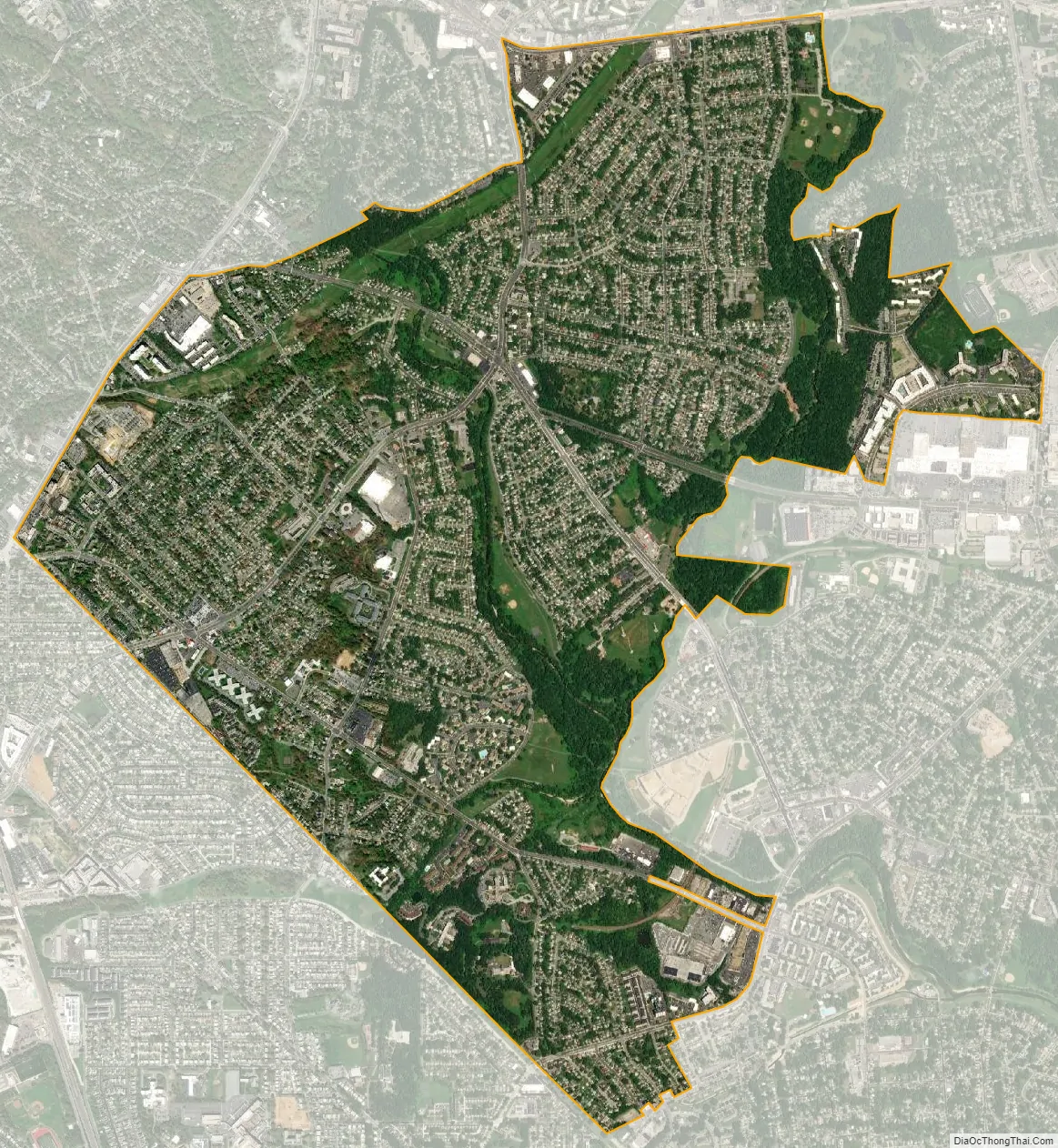
Chillum, the neighborhood, is contained between the Northwest Branch Anacostia River to the east, East West Highway (MD 410) and the Sligo Creek River to the north, New Hampshire Avenue (MD 650) to the west, and Eastern Avenue NE to the south. Chillum borders the adjacent communities of Avondale, Green Meadows, and Carole Highlands in Prince George’s County as well as the city of Takoma Park in Montgomery County, and the Riggs Park (also known as, “Lamond Riggs”), Queens Chapel, and North Michigan Park neighborhoods of Northeast Washington D.C.
| Name: | Chillum CDP |
|---|---|
| LSAD Code: | 57 |
| LSAD Description: | CDP (suffix) |
| State: | Maryland |
| County: | Prince George’s County |
| Elevation: | 148 ft (45 m) |
| Total Area: | 3.40 sq mi (8.81 km²) |
| Land Area: | 3.37 sq mi (8.73 km²) |
| Water Area: | 0.03 sq mi (0.08 km²) |
| Total Population: | 36,039 |
| Population Density: | 10,687.72/sq mi (4,126.52/km²) |
| ZIP code: | 20782, 20783, and 20912 |
| Area code: | 301, 240 |
| FIPS code: | 2416875 |
| GNISfeature ID: | 0597239 |
Online Interactive Map
Click on ![]() to view map in "full screen" mode.
to view map in "full screen" mode.
Chillum location map. Where is Chillum CDP?


History
Chillum takes its name from “Chillum Castle Manor,” the 4,443-acre (17.98 km) land patent established in 1763, by William Dudley Digges. It included lands in the present-day District of Columbia and in Prince George’s County, and was composed of previously established land patents such as Henrietta Maria, Widows Purchase, Yarrow and Yarrow Head. Chillum Castle Manor was named after Chilham Castle, the old home of Sir Dudley Digges, an ancestor of William Dudley Digges, in Kent, England.
The manor house for the Henrietta Maria parcel was named Green Hill. It was home to William Dudley Digges and was the place where Pierre L’Enfant, designer of nearby Washington, D.C., died in destitution in 1825. He remained buried at the Green Hill property until being re-interred at Arlington National Cemetery in 1909. The Green Hill plantation was subsequently purchased by George Washington Riggs, who built the present Green Hill historic home in 1868.
Since this area was not served by public transportation, such as a streetcar, Chillum remained rural in character into the 1930s. Beginning in the mid-1930s, the area of Chillum that is close to the District of Columbia border was subdivided into lots. Developers promoted the area’s convenient access into the city as well as its water, gas, and electricity supply. The first platted developments in the late 1930s included Chillum Gardens and Oakdale Terrace. The developers of these communities sold the lots but left the construction of houses to the lot owners. Consequently, the communities were slow to develop. In contrast, the developer-built Green Meadows and Brookdale Manor were platted in the early 1940s and completed by 1942. Other developer-built communities begun in the 1940s include Chillumgate (1946) and Michigan Hills Park (1940s). Several subdivisions were constructed along Riggs Road, Sargent Road, and Sligo Creek Park in the 1950s, including Sargent Knolls (1950), Bel Air Estates (1955), Parkland (1955), Carrington (1957), and Miller Estates (mid-1950s-early 1960s). The street pattern of these communities are typical of their period. They have a grid pattern of streets broken by a few curvilinear roadways and cul-de-sacs. In addition to single-family residences, two apartment communities were constructed in 1949. The Chillum Heights Apartments consist of three story brick structures containing a combined total of 1,147 units. Larger-scale apartment complexes and mid-rise structures were constructed in the 1960s.
Chillum Road Map

Chillum city Satellite Map
Geography
Chillum is located at 38°58′6″N 76°58′45″W / 38.96833°N 76.97917°W / 38.96833; -76.97917 (38.968210, −76.979046).
According to the United States Census Bureau, the CDP has a total area of 3.4 square miles (8.9 km), of which 3.4 square miles (8.8 km) is land and 0.039 square miles (0.1 km), or 0.94%, is water. Chillum is unincorporated and does not have its own zipcode; therefore it relies on its neighboring city of Hyattsville for its postal addresses/ zipcodes. While a vast majority of the residents living in/ businesses located in Chillum, MD are assigned the Hyattsville postal zipcodes of either 20782, or 20783, there are a few residents living on the far west side of Chillum/ businesses located very close to New Hampshire Avenue (MD 650) and the Prince George’s/ Montgomery County Line, bordering the city of Takoma Park, MD, are assigned the Takoma Park, MD zipcode of 20912. Residents of Chillum that are assigned Takoma Park’s 20912 zipcode have Takoma Park addresses though they are not even located within Takoma Park’s boundaries. All of the other residents living in / businesses located in Chillum, have Hyattsville addresses.
See also
Map of Maryland State and its subdivision: Map of other states:- Alabama
- Alaska
- Arizona
- Arkansas
- California
- Colorado
- Connecticut
- Delaware
- District of Columbia
- Florida
- Georgia
- Hawaii
- Idaho
- Illinois
- Indiana
- Iowa
- Kansas
- Kentucky
- Louisiana
- Maine
- Maryland
- Massachusetts
- Michigan
- Minnesota
- Mississippi
- Missouri
- Montana
- Nebraska
- Nevada
- New Hampshire
- New Jersey
- New Mexico
- New York
- North Carolina
- North Dakota
- Ohio
- Oklahoma
- Oregon
- Pennsylvania
- Rhode Island
- South Carolina
- South Dakota
- Tennessee
- Texas
- Utah
- Vermont
- Virginia
- Washington
- West Virginia
- Wisconsin
- Wyoming


