Map of Blandford CDP

Map of Blandford CDP

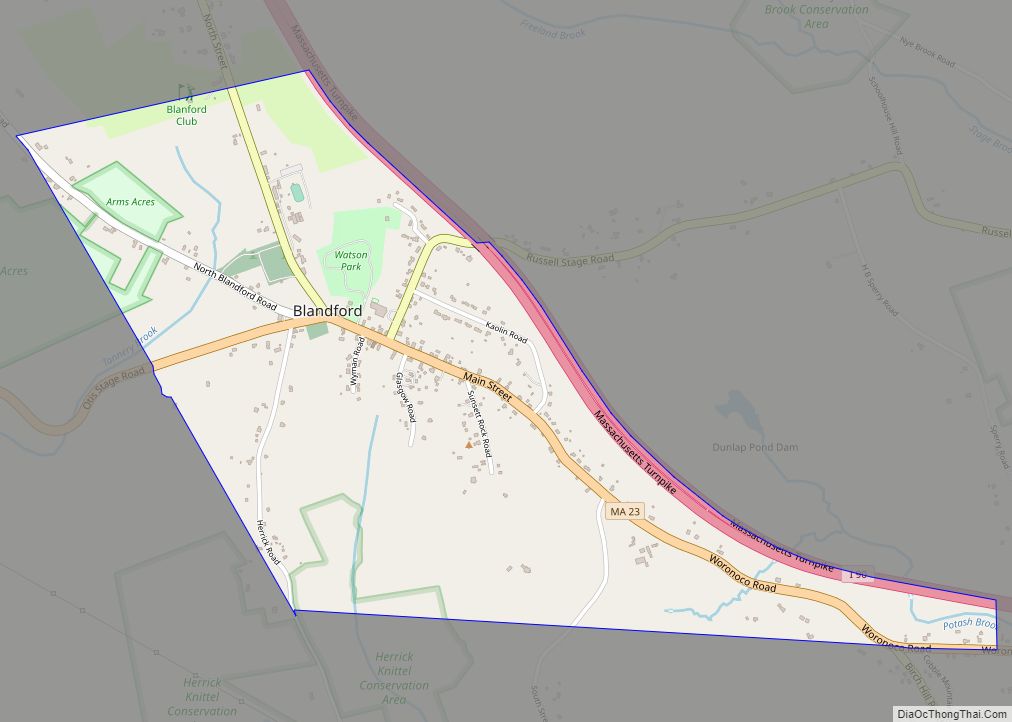
Blandford is a census-designated place that comprises the populated center of the town of Blandford in Hampden County, Massachusetts, United States. The population of the CDP was 393 at the 2010 census, out of 1,233 in the entire town of Blandford. It is part of the Springfield, Massachusetts Metropolitan Statistical Area. Blandford CDP overview: Name: … Read more

Map of Beverly city, Massachusetts

Map of Beverly city, Massachusetts

Beverly is a city in Essex County, Massachusetts, and a suburb of Boston. The population was 42,670 at the time of the 2020 United States Census. A resort, residential, and manufacturing community on the Massachusetts North Shore, Beverly includes Ryal Side, North Beverly, Montserrat, Beverly Farms and Prides Crossing. Beverly is a rival of Marblehead … Read more

Map of Bourne CDP

Map of Bourne CDP

The village of Bourne is a census-designated place (CDP) in the town of Bourne in Barnstable County, Massachusetts, United States. The population was 1,418 at the 2010 census, out of 19,754 in the town of Bourne as a whole. Bourne CDP overview: Name: Bourne CDP LSAD Code: 57 LSAD Description: CDP (suffix) State: Massachusetts County: … Read more

Map of Braintree Town city

Map of Braintree Town city

Braintree Town city overview: Name: Braintree Town city LSAD Code: 25 LSAD Description: city (suffix) State: Massachusetts County: Norfolk County FIPS code: 2507740 Online Interactive Map Braintree Town online map. Source: Basemap layers from Google Map, Open Street Map (OSM), Arcgisonline, Wmflabs. Boundary Data from Database of Global Administrative Areas. Braintree Town location map. Where … Read more

Map of Boxford CDP

Map of Boxford CDP

Boxford is a census-designated place (CDP) in the town of Boxford in Essex County, Massachusetts, United States. The population was 2,339 at the 2010 census. Boxford CDP overview: Name: Boxford CDP LSAD Code: 57 LSAD Description: CDP (suffix) State: Massachusetts County: Essex County Elevation: 102 ft (31 m) Total Area: 5.47 sq mi (14.18 km²) Land Area: 5.36 sq mi (13.89 km²) Water … Read more

Map of Brookfield CDP, Massachusetts

Map of Brookfield CDP, Massachusetts

Brookfield is a census-designated place (CDP) comprising the main village in the town of Brookfield, Worcester County, Massachusetts, United States. Massachusetts Route 9 passes through the center of the village, leading east 6 miles (10 km) to Spencer and west 9 miles (14 km) to Ware. Massachusetts Route 148 crosses Route 9 in the village center, leading … Read more

Map of Bridgewater Town city

Map of Bridgewater Town city

Bridgewater Town city overview: Name: Bridgewater Town city LSAD Code: 25 LSAD Description: city (suffix) State: Massachusetts FIPS code: 2508130 Online Interactive Map Bridgewater Town online map. Source: Basemap layers from Google Map, Open Street Map (OSM), Arcgisonline, Wmflabs. Boundary Data from Database of Global Administrative Areas. Bridgewater Town location map. Where is Bridgewater Town … Read more

Map of Brewster CDP, Massachusetts

Map of Brewster CDP, Massachusetts

Brewster is a census-designated place (CDP) in the town of Brewster in Barnstable County, Massachusetts, United States. The population was 2,000 at the 2010 census, out of 9,820 in the town of Brewster as a whole. Brewster CDP overview: Name: Brewster CDP LSAD Code: 57 LSAD Description: CDP (suffix) State: Massachusetts County: Barnstable County Elevation: … Read more

Map of Buzzards Bay CDP

Map of Buzzards Bay CDP

Buzzards Bay is a census-designated place (CDP) in the town of Bourne in Barnstable County, Massachusetts. The population was 3,859 at the 2010 census. It is the most populous of the five CDPs in Bourne. Buzzards Bay CDP overview: Name: Buzzards Bay CDP LSAD Code: 57 LSAD Description: CDP (suffix) State: Massachusetts County: Barnstable County … Read more

Map of Burlington CDP, Massachusetts

Map of Burlington CDP, Massachusetts

Burlington is a town in Middlesex County, Massachusetts, United States. The population was 26,377 at the 2020 census. Burlington CDP overview: Name: Burlington CDP LSAD Code: 57 LSAD Description: CDP (suffix) State: Massachusetts County: Middlesex County Incorporated: February 28, 1799 Elevation: 218 ft (66 m) Total Area: 11.9 sq mi (30.8 km²) Land Area: 11.8 sq mi (30.6 km²) Water Area: 0.1 sq mi (0.2 km²) … Read more

Map of Brookline CDP

Map of Brookline CDP

Brookline /ˈbrʊklaɪn/ is a town in Norfolk County, Massachusetts, in the United States, and part of the Boston metropolitan area. Brookline borders six of Boston‘s neighborhoods: Brighton, Allston, Fenway–Kenmore, Mission Hill, Jamaica Plain, and West Roxbury. The city of Newton lies to the west of Brookline. Brookline was first settled in 1638 as a hamlet … Read more

Map of Cheshire CDP

Map of Cheshire CDP, Massachusetts

Cheshire is a census-designated place (CDP) located in the town of Cheshire in Berkshire County, Massachusetts, United States. The population was 514 at the 2010 census, out of 3,235 in the entire town of Cheshire. Cheshire CDP overview: Name: Cheshire CDP LSAD Code: 57 LSAD Description: CDP (suffix) State: Massachusetts County: Berkshire County Elevation: 994 ft … Read more