Map of Deckerville village

Map of Deckerville village

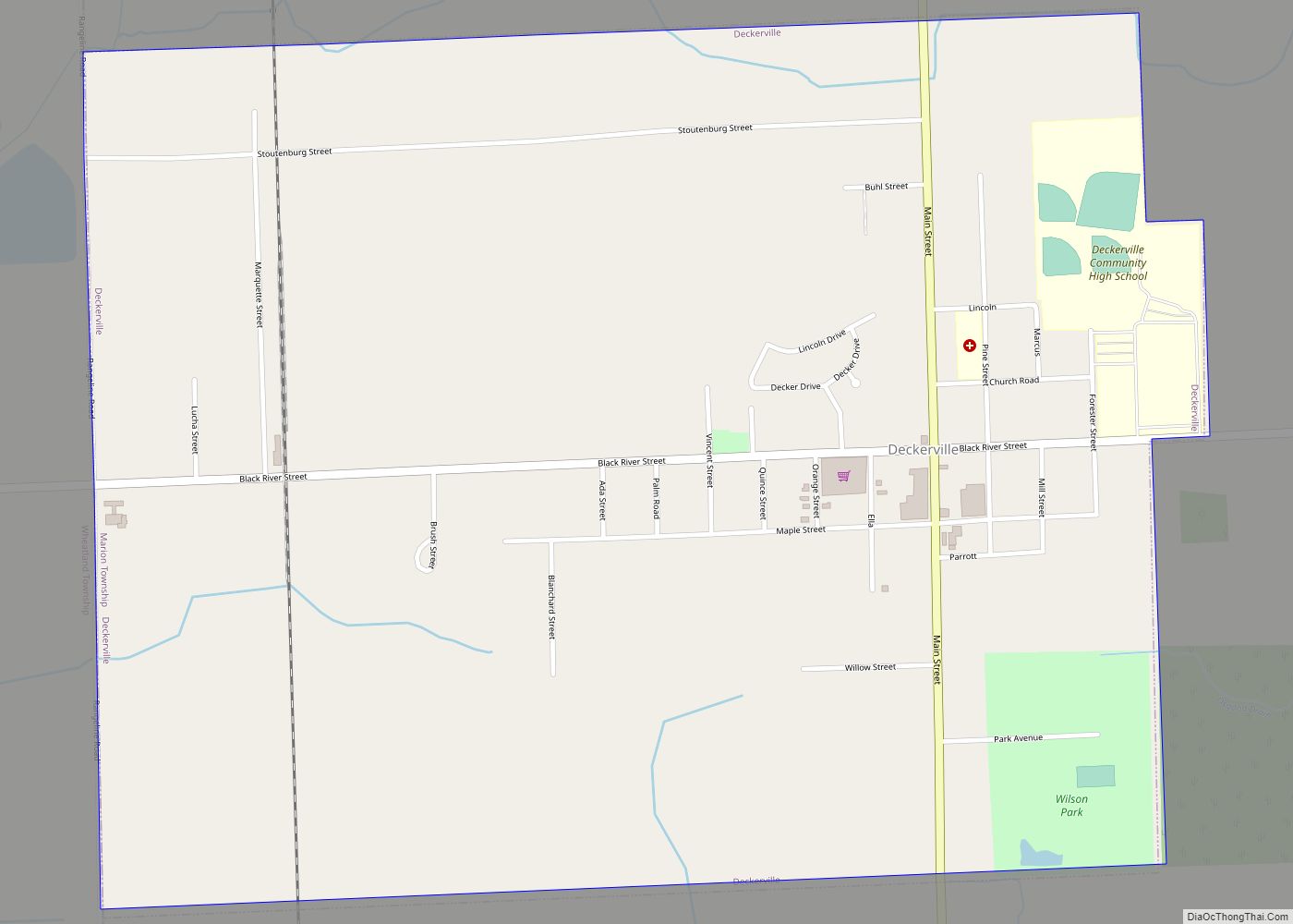
Deckerville is a village in Sanilac County in the U.S. state of Michigan. The population was 830 at the 2010 census. Deckerville village overview: Name: Deckerville village LSAD Code: 47 LSAD Description: village (suffix) State: Michigan County: Sanilac County Elevation: 827 ft (252 m) Total Area: 1.25 sq mi (3.23 km²) Land Area: 1.25 sq mi (3.23 km²) Water Area: 0.00 sq mi (0.00 km²) Total … Read more

Map of Decatur village, Michigan

Map of Decatur village, Michigan

Decatur is a village in Van Buren County, Michigan, United States. The population was 1,819 at the 2010 census. The village is located within Decatur Township. Decatur village overview: Name: Decatur village LSAD Code: 47 LSAD Description: village (suffix) State: Michigan County: Van Buren County Elevation: 787 ft (240 m) Total Area: 1.43 sq mi (3.70 km²) Land Area: 1.35 sq mi … Read more

Map of Dearborn Heights city

Map of Dearborn Heights city

Dearborn Heights is a city in Wayne County in the U.S. state of Michigan. With a population of 63,292 at the 2020 census., Dearborn Heights is part of the Detroit metropolitan area, and is considered a bedroom community. Dearborn Heights city overview: Name: Dearborn Heights city LSAD Code: 25 LSAD Description: city (suffix) State: Michigan … Read more

Map of De Tour Village village

Map of De Tour Village village

De Tour Village village overview: Name: De Tour Village village LSAD Code: 47 LSAD Description: village (suffix) State: Michigan County: Chippewa County FIPS code: 2621780 Online Interactive Map De Tour Village online map. Source: Basemap layers from Google Map, Open Street Map (OSM), Arcgisonline, Wmflabs. Boundary Data from Database of Global Administrative Areas. De Tour … Read more

Map of Davison city

Map of Davison city

Davison is a city in Genesee County in the U.S. state of Michigan and a suburb of Flint. The population was 5,536 at the 2000 census and fell to 5,173 by the 2010 census. Davison is located within Davison Township survey township area (7N 8E), but is administratively autonomous. Davison was named after Judge Norman … Read more

Map of Delton CDP

Map of Delton CDP

Delton is a census-designated place (CDP) in Barry Township in Barry County, Michigan, United States. The population was 872 at the 2010 census. Delton CDP overview: Name: Delton CDP LSAD Code: 57 LSAD Description: CDP (suffix) State: Michigan County: Barry County Elevation: 947 ft (289 m) Total Area: 2.55 sq mi (6.61 km²) Land Area: 2.21 sq mi (5.74 km²) Water Area: 0.34 sq mi … Read more

Map of Deerfield village, Michigan

Map of Deerfield village, Michigan

Deerfield is a village in Lenawee County in the U.S. state of Michigan. The population was 898 at the 2010 census. The village is located within Deerfield Township. Deerfield was the birthplace of actor and philanthropist Danny Thomas. Deerfield village overview: Name: Deerfield village LSAD Code: 47 LSAD Description: village (suffix) State: Michigan County: Lenawee … Read more

Map of Dexter city, Michigan

Map of Dexter city, Michigan

The City of Dexter is a city situated in Washtenaw County, Michigan, in the United States. As of the 2021 Census, the city’s population was recorded at 6,644. Residential areas in Dexter include the original settlements along the Baker Road, Central Street, and Dexter-Ann Arbor Road corridors, as well as newer subdivisions and condominiums in … Read more

Map of DeWitt city, Michigan

Map of DeWitt city, Michigan

DeWitt is a city in Clinton County in the U.S. state of Michigan. The population was 4,776 at the 2020 census. The city is located north of Interstate 69 and west of U.S. Route 127, just north of the city of Lansing. DeWitt city overview: Name: DeWitt city LSAD Code: 25 LSAD Description: city (suffix) … Read more

Map of Detroit Beach CDP

Map of Detroit Beach CDP

Detroit Beach is an unincorporated community and census-designated place (CDP) in Monroe County in the U.S. state of Michigan. The population was 1,957 at the 2020 census. The CDP is located within Frenchtown Charter Township, and as an unincorporated community, Detroit Beach has no legal autonomy of its own. Detroit Beach and its surrounding communities … Read more

Map of Dowling CDP

Map of Dowling CDP

Dowling is a census-designated place (CDP) in Baltimore Township in Barry County, Michigan, United States. The population was 374 at the 2010 census. Dowling CDP overview: Name: Dowling CDP LSAD Code: 57 LSAD Description: CDP (suffix) State: Michigan County: Barry County Elevation: 952 ft (290 m) Total Area: 6.29 sq mi (16.28 km²) Land Area: 6.08 sq mi (15.75 km²) Water Area: 0.20 sq mi … Read more

Map of Dowagiac city

Map of Dowagiac city

Dowagiac (/dəˈwɑːdʒæk/ də-WAH-jak) is a city in Cass County in the U.S. state of Michigan. The population was 5,879 at the 2010 census. It is part of the South Bend–Mishawaka, IN-MI, Metropolitan Statistical Area. Dowagiac is situated at the corner of four townships: Wayne Township to the northeast, LaGrange Township to the southeast, Pokagon Township … Read more