Map of Lake Odessa village

Map of Lake Odessa village

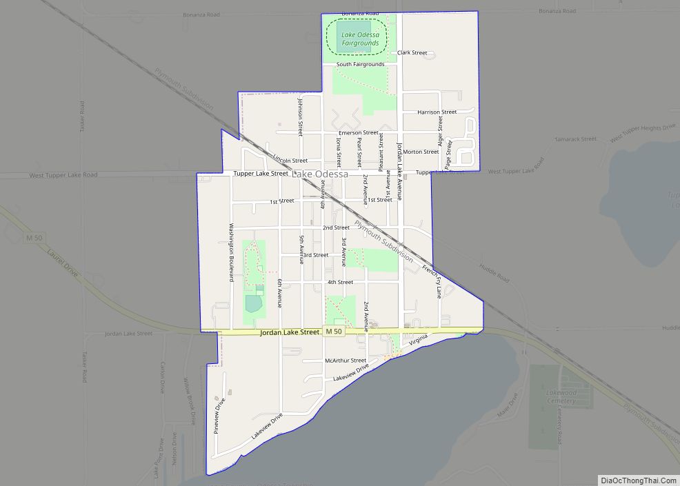
Lake Odessa is a village in Ionia County of the U.S. state of Michigan. The population was 2,018 at the 2010 census. It is located in the southern portion of the county in Odessa Township on the northeast shore of Jordan Lake, which is the boundary with Barry County. Since 1987, Lake Odessa has been … Read more

Map of Lake Michigan Beach CDP

Map of Lake Michigan Beach CDP

Lake Michigan Beach is an unincorporated community in Berrien County in the U.S. state of Michigan. It is a census-designated place (CDP) for statistical purposes, without any legal status as a municipality. The population was 1,216 at the 2010 census. The community is in Hagar Township on the shore of Lake Michigan. The area is … Read more

Map of Lake Linden village

Map of Lake Linden village

Lake Linden is a village in Houghton County in the U.S. state of Michigan. The population was 1,007 at the 2010 census. The village is mostly within Schoolcraft Township, though a tiny portion lies in Torch Lake Township. Lake Linden village overview: Name: Lake Linden village LSAD Code: 47 LSAD Description: village (suffix) State: Michigan … Read more

Map of Lake Leelanau CDP

Map of Lake Leelanau CDP

Lake Leelanau is an unincorporated community and census-designated place (CDP) in Leland Township, Leelanau County, Michigan, near the lake of the same name. As of the 2020 census it had a population of 229. It is situated along M-204 at the “narrows” that separate North and South Lake Leelanau. Lake Leelanau CDP overview: Name: Lake … Read more

Map of Lake Isabella village, Michigan

Map of Lake Isabella village, Michigan

Lake Isabella is a village split between Sherman Township and Broomfield Township within Isabella County in the U.S. state of Michigan. The population grew to 1,681 people as of the 2010 Census, making the community one of the state’s ten fastest growing communities in terms of percentage, with an increase of 35% from the 2000 … Read more

Map of Lakewood Club village

Map of Lakewood Club village

Lakewood Club is a village in Dalton Township of Muskegon County in the U.S. state of Michigan. The population was 1,291 at the 2010 census. Lakewood Club village overview: Name: Lakewood Club village LSAD Code: 47 LSAD Description: village (suffix) State: Michigan County: Muskegon County Elevation: 679 ft (207 m) Total Area: 2.07 sq mi (5.36 km²) Land Area: 1.91 sq mi … Read more

Map of Lakeview village, Michigan

Map of Lakeview village, Michigan

Lakeview is a village in Cato Township in Montcalm County of the U.S. state of Michigan. The population was 1,007 at the 2010 census. The village is within Cato Township. Lakeview village overview: Name: Lakeview village LSAD Code: 47 LSAD Description: village (suffix) State: Michigan County: Montcalm County Elevation: 948 ft (289 m) Total Area: 1.83 sq mi (4.74 km²) … Read more

Map of Lakes of the North CDP

Map of Lakes of the North CDP

Lakes of the North is an unincorporated community and census-designated place (CDP) in Antrim County in the U.S. state of Michigan. The CDP is located in Mancelona Township to the south and Star Township to the north. The population of the CDP was 1,044 at the 2020 census. Lakes of the North CDP overview: Name: … Read more

Map of Lake Victoria CDP

Map of Lake Victoria CDP

Lake Victoria is an unincorporated community and census-designated place (CDP) in Clinton County in the U.S. state of Michigan. It is located in Victor Township. As of the 2010 census, it had a population of 930. Lake Victoria CDP overview: Name: Lake Victoria CDP LSAD Code: 57 LSAD Description: CDP (suffix) State: Michigan County: Clinton … Read more

Map of Lake Orion village

Map of Lake Orion village

Lake Orion (/ˈɒriən/ ORR-ee-ən) is a village in the northern outskirts of Metro Detroit in Oakland County, Michigan, United States. The population was 2,973 at the 2010 census. “Lake Orion” can refer to either the village or the much larger Orion Township, of which the village is a part. Lake Orion began as a resort … Read more

Map of Lawrence village, Michigan

Map of Lawrence village, Michigan

Lawrence is a village in Van Buren County in the U.S. state of Michigan. The population was 996 at the 2010 census. The village is located within Lawrence Township. It is host to an annual Ox Roast, Homecoming festival, and Farmer’s Market. Lawrence village overview: Name: Lawrence village LSAD Code: 47 LSAD Description: village (suffix) … Read more

Map of Laurium village

Map of Laurium village

Laurium (/ˈlɔːriəm/; LAW-ri-um or /ˈleɪriəm/ LAIR-i-um) is a village in Calumet Township, Houghton County in the U.S. state of Michigan, in the center of the Keweenaw Peninsula. The population was 1,977 at the 2010 census. The village is mostly surrounded by Calumet Township, with a small portion bordering Schoolcraft Township on the east.  The portion … Read more