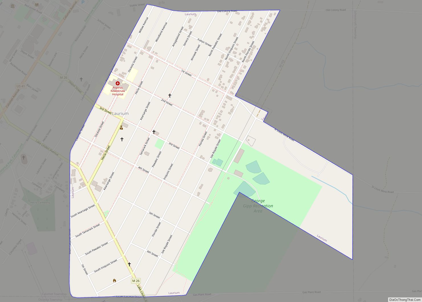
Map of Lathrup Village city

Map of Lathrup Village city

Lathrup Village (/ˈleɪθrəp/ LAY-thrəp) is a city in Oakland County in the U.S. state of Michigan. Per of the 2020 census, the population was 4,088. This city is surrounded by the city of Southfield. The I-696 / Reuther Freeway goes through nearly the east–west center of town, and Southfield Road goes nearly through the north–south … Read more

Map of Lapeer city

Map of Lapeer city

Lapeer (/ləpir/ lə-PEER) is a city in the U.S. state of Michigan and is the county seat of Lapeer County. As of the 2020 census, the city population was 9,023. Most of the city was incorporated from land that was formerly in Lapeer Township, though portions were also annexed from Mayfield Township and Elba Township. … Read more

Map of Lambertville CDP

Map of Lambertville CDP, Michigan

Lambertville is an unincorporated community and census-designated place (CDP) in Monroe County in the U.S. state of Michigan. The population was 10,433 at the 2020 census. The CDP is located within Bedford Township. The Lambertville 48144 ZIP Code serves the southwest part of Bedford Township and small portions of Whiteford Township to the west. Lambertville … Read more

Map of Leonard village

Map of Leonard village, Michigan

Leonard is a village in Addison Township, Oakland County in the U.S. state of Michigan. The population was 403 at the 2010 census. Leonard village overview: Name: Leonard village LSAD Code: 47 LSAD Description: village (suffix) State: Michigan County: Oakland County Incorporated: 1889 Elevation: 1,007 ft (307 m) Land Area: 0.99 sq mi (2.57 km²) Water Area: 0.00 sq mi (0.00 km²) Population … Read more

Map of Lennon village

Map of Lennon village

Lennon is a village in the U.S. state of Michigan. The population was 511 at the 2010 census. The village is located along M-13 within Venice Township in Shiawassee County to the west and Clayton Township in Genesee County to the east. Lennon village overview: Name: Lennon village LSAD Code: 47 LSAD Description: village (suffix) … Read more

Map of Leland CDP, Michigan

Map of Leland CDP, Michigan

Leland (/ˈliːlənd/ LEE-lənd) is an unincorporated community and census-designated place (CDP) in the U.S. state of Michigan. As of the 2020 census it had a population of 410. From 1883 to 2004, Leland was the county seat of Leelanau County, which has since moved to Suttons Bay Township. Part of Leland Township, Leland is situated … Read more

Map of Le Roy village, Michigan

Map of Le Roy village, Michigan

Le Roy village overview: Name: Le Roy village LSAD Code: 47 LSAD Description: village (suffix) State: Michigan County: Osceola County FIPS code: 2647100 Online Interactive Map Le Roy online map. Source: Basemap layers from Google Map, Open Street Map (OSM), Arcgisonline, Wmflabs. Boundary Data from Database of Global Administrative Areas. Le Roy location map. Where … Read more

Map of Lawton village, Michigan

Map of Lawton village, Michigan

Lawton is a village in southeastern Van Buren County, Michigan, United States. The population was 1,900 at the 2010 census. Lawton village overview: Name: Lawton village LSAD Code: 47 LSAD Description: village (suffix) State: Michigan County: Van Buren County Elevation: 791 ft (241 m) Total Area: 2.33 sq mi (6.02 km²) Land Area: 2.29 sq mi (5.93 km²) Water Area: 0.04 sq mi (0.09 km²) Total … Read more

Map of Lexington village, Michigan

Map of Lexington village, Michigan

Lexington is a village in Sanilac County in the U.S. state of Michigan. The population was 1,178 at the 2010 census. The village is located within Lexington Township. Lexington village overview: Name: Lexington village LSAD Code: 47 LSAD Description: village (suffix) State: Michigan County: Sanilac County Elevation: 617 ft (188 m) Total Area: 1.39 sq mi (3.61 km²) Land Area: … Read more

Map of Lewiston CDP, Michigan

Map of Lewiston CDP, Michigan

Lewiston is an unincorporated community in Montmorency County, Michigan, United States. It is a census-designated place (CDP) used for statistical purposes. The population was 996 at the 2020 census. Lewiston CDP overview: Name: Lewiston CDP LSAD Code: 57 LSAD Description: CDP (suffix) State: Michigan County: Montmorency County Elevation: 1,243 ft (379 m) Total Area: 4.12 sq mi (10.66 km²) Land … Read more

Map of Levering CDP

Map of Levering CDP

Levering is an unincorporated community and census-designated place (CDP) in Emmet County in the U.S. state of Michigan. As of the 2010 census, the CDP had a population of 215. Levering CDP overview: Name: Levering CDP LSAD Code: 57 LSAD Description: CDP (suffix) State: Michigan County: Emmet County Elevation: 758 ft (231 m) Total Area: 0.44 sq mi (1.13 km²) … Read more

Map of Level Park-Oak Park CDP

Map of Level Park-Oak Park CDP

Level Park-Oak Park CDP overview: Name: Level Park-Oak Park CDP LSAD Code: 57 LSAD Description: CDP (suffix) State: Michigan County: Calhoun County FIPS code: 2647230 Online Interactive Map Level Park-Oak Park online map. Source: Basemap layers from Google Map, Open Street Map (OSM), Arcgisonline, Wmflabs. Boundary Data from Database of Global Administrative Areas. Level Park-Oak … Read more