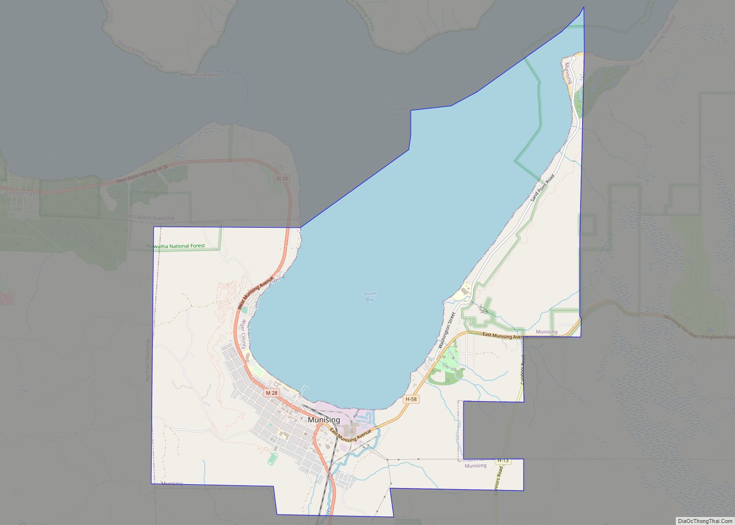
Map of Mulliken village
Mulliken is a village in Eaton County in the U.S. state of Michigan. The population was 553 at the 2010 census. The village is within Roxand Township. Mulliken village overview: Name: Mulliken village LSAD Code: 47 LSAD Description: village (suffix) State: Michigan County: Eaton County Elevation: 863 ft (263 m) Total Area: 1.04 sq mi (2.70 km²) Land Area: 1.04 sq mi ... Read more
Map of Mulliken village
Map of Muir village, Michigan
Muir is a village in Lyons Township, Ionia County in the U.S. state of Michigan. The population was 604 at the 2010 census. Muir village overview: Name: Muir village LSAD Code: 47 LSAD Description: village (suffix) State: Michigan County: Ionia County Elevation: 663 ft (202 m) Total Area: 0.76 sq mi (1.96 km²) Land Area: 0.71 sq mi (1.84 km²) Water Area: 0.04 sq mi ... Read more
Map of Muir village, Michigan
Map of Mount Pleasant city, Michigan
Mount Pleasant is a city in the U.S. state of Michigan. The city is the county seat of Isabella County, which is part of Central Michigan. The population of Mount Pleasant was 21,688 as of the 2020 census. The city is surrounded by Union Charter Township, but is politically independent. Part of the city (with ... Read more
Map of Mount Pleasant city, Michigan
Map of Mount Morris city, Michigan
Mount Morris is a city in Genesee County in the U.S. state of Michigan. The population was 3,086 at the 2010 census. The city is bordered by Mount Morris Township on the west and Genesee Township on the east. It was named after Mount Morris, New York, because many of the early settlers had come ... Read more
Map of Mount Morris city, Michigan
Map of Negaunee city
Negaunee (/nəˈɡɔːni/ nə-GAW-nee or locally /ˈnəˈɡɒni/ nə-GAH-nee) is a city in Marquette County in the U.S. state of Michigan. The population was 4,627 at the 2020 census. The city is located at the southwest corner of Negaunee Township, which is administratively separate, in the Upper Peninsula. The city is home to a luge track. The ... Read more
Map of Negaunee city
Map of Nashville village, Michigan
Nashville is a village in Barry County in the U.S. state of Michigan. The population was 1,628 at the 2010 census. The township exists largely within Castleton Township, with a small portion extending south into Maple Grove Township. Nashville village overview: Name: Nashville village LSAD Code: 47 LSAD Description: village (suffix) State: Michigan County: Barry ... Read more
Map of Nashville village, Michigan
Map of Napoleon CDP, Michigan
Napoleon is an unincorporated community and census-designated place (CDP) in Jackson County in the U.S. state of Michigan. The population of the CDP was 1,258 at the 2010 census. It is located within Napoleon Township. Napoleon CDP overview: Name: Napoleon CDP LSAD Code: 57 LSAD Description: CDP (suffix) State: Michigan County: Jackson County Elevation: 961 ft ... Read more
Map of Napoleon CDP, Michigan
Map of Muskegon city
Muskegon (/məˈskiːɡən/ məs-KEE-gən), a city in the US. state of Michigan, is the county seat of Muskegon County. Situated around a harbor of Lake Michigan, Muskegon is known for fishing, sailing regattas, and pleasure boating, and as a commercial- and cruise-ship port. It is a popular vacation destination because of the expansive freshwater beaches, historic ... Read more
Map of Muskegon city
Map of Muskegon Heights city
Muskegon Heights is a city in Muskegon County in the U.S. state of Michigan. The population was 10,856 at the 2010 census. Muskegon Heights city overview: Name: Muskegon Heights city LSAD Code: 25 LSAD Description: city (suffix) State: Michigan County: Muskegon County Elevation: 623 ft (190 m) Total Area: 3.19 sq mi (8.25 km²) Land Area: 3.19 sq mi (8.25 km²) Water Area: ... Read more
Map of Muskegon Heights city
Map of New Era village
New Era is a village in Shelby Township, Oceana County in the U.S. state of Michigan. The population was 451 at the 2010 census. New Era is the birthplace of Caldecott Medal-winning children’s author Verna Aardema. The village is near the halfway point on the Hart-Montague Trail, and local businesses woo visiting cyclists as they ... Read more
Map of New Era village
Map of New Buffalo city, Michigan
New Buffalo is a city in Berrien County in the U.S. state of Michigan. The population was 1,883 at the time of the 2010 census and 1,708 at the 2020 census. New Buffalo city overview: Name: New Buffalo city LSAD Code: 25 LSAD Description: city (suffix) State: Michigan County: Berrien County Incorporated: 1836 (village)1965 (city) ... Read more
Map of New Buffalo city, Michigan
Map of New Baltimore city, Michigan
New Baltimore is a city in Macomb County in the U.S. state of Michigan. The population was 12,117 at the 2020 census. New Baltimore is a northern suburb of Metro Detroit and is located along the northern shores of Lake St. Clair. New Baltimore city overview: Name: New Baltimore city LSAD Code: 25 LSAD Description: ... Read more
Map of New Baltimore city, Michigan