Map of Novi city

Map of Novi city

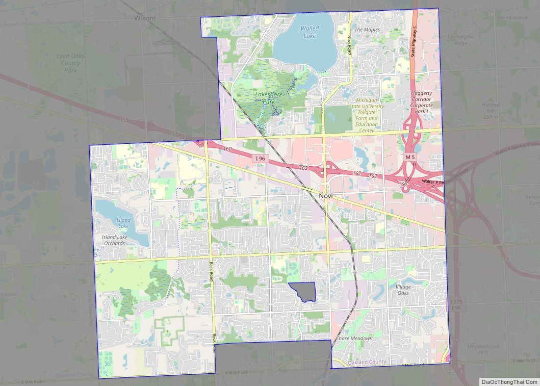
Novi (/ˈnoʊvaɪ/ NOVE-eye) is a city in Oakland County in the U.S. state of Michigan. As of the 2020 census, the population was 66,243, an increase of 20% from the 2010 census. A northern suburb of Metro Detroit, Novi is located about 24 miles (38.6 km) northwest of the city of Detroit and about 16 miles … Read more

Map of Norwood CDP, Michigan

Map of Norwood CDP, Michigan

Norwood is an unincorporated community and census-designated place (CDP) in Charlevoix County in the U.S. state of Michigan. The population of the CDP was 144 at the 2020 census. It is located along the shores of Lake Michigan in Norwood Township. Norwood CDP overview: Name: Norwood CDP LSAD Code: 57 LSAD Description: CDP (suffix) State: … Read more

Map of Norway city, Michigan

Map of Norway city, Michigan

Norway is a city in Dickinson County in the U.S. state of Michigan. The population was 2,845 at the 2010 census. It is part of the Iron Mountain, MI–WI Micropolitan Statistical Area. The city is in the southwest of Norway Township, but is politically independent. It is on U.S. Highway 2 (US 2), which connects with M-95 … Read more

Map of Norton Shores city

Map of Norton Shores city

Norton Shores is a city in Muskegon County in the U.S. state of Michigan. The population was 23,994 at the 2010 census. Norton Shores city overview: Name: Norton Shores city LSAD Code: 25 LSAD Description: city (suffix) State: Michigan County: Muskegon County Elevation: 614 ft (187 m) Total Area: 24.63 sq mi (63.78 km²) Land Area: 23.24 sq mi (60.20 km²) Water Area: … Read more

Map of Northville city

Map of Northville city, Michigan

Northville is a city in Oakland and Wayne counties in the U.S. state of Michigan. The population was 6,119 at the 2020 census. Northville is a suburb of Metro Detroit and is located about 11 miles (17.7 km) west of the city of Detroit and 17 miles (27.4 km) northeast of Ann Arbor. Part of the city … Read more

Map of Oakley village, Michigan

Map of Oakley village, Michigan

Oakley is a village in Saginaw County in the U.S. state of Michigan. The population was 290 at the 2010 census. The village is within Brady Township, although about half of the village would lie within Chesaning Township on the east, if the boundary line had not been adjusted. Oakley village overview: Name: Oakley village … Read more

Map of Oak Park city, Michigan

Map of Oak Park city, Michigan

Oak Park is a city in Oakland County in the U.S. state of Michigan. As of the 2020 census, the population of Oak Park was 29,560. As a northern suburb of Metro Detroit, Oak Park shares its southern border with the city of Detroit. Oak Park city overview: Name: Oak Park city LSAD Code: 25 … Read more

Map of Oak Hill CDP, Michigan

Map of Oak Hill CDP, Michigan

Oak Hill is an unincorporated community and census-designated place in Manistee County, Michigan, United States. Its population was 569 as of the 2010 census. Oak Hill CDP overview: Name: Oak Hill CDP LSAD Code: 57 LSAD Description: CDP (suffix) State: Michigan County: Manistee County Elevation: 656 ft (200 m) Total Area: 0.50 sq mi (1.30 km²) Land Area: 0.50 sq mi (1.30 km²) … Read more

Map of Okemos CDP

Map of Okemos CDP

Okemos (/ˈoʊkəməs/ OH-kə-məss) is a census-designated place (CDP) in Ingham County in the U.S. state of Michigan. The population of the CDP was 25,121 at the 2020 census. Okemos is part of the urban area of Lansing–East Lansing, and is located nearby the campus of Michigan State University. Okemos is located mostly within Meridian Charter … Read more

Map of Oden CDP, Michigan

Map of Oden CDP, Michigan

Oden is an unincorporated community and census-designated place (CDP) in Emmet County in the U.S. state of Michigan. As of the 2010 census, the CDP had a population of 363. It is located within Littlefield Township. Oden CDP overview: Name: Oden CDP LSAD Code: 57 LSAD Description: CDP (suffix) State: Michigan County: Emmet County Elevation: … Read more

Map of Onekama village

Map of Onekama village

Onekama (/oʊˈnɛkəmə/ oh-NEK-ə-mə) is a village in Manistee County in the U.S. state of Michigan. The population was 399 at the 2020 census. The village is located on the shores of Portage Lake and is surrounded by Onekama Township. The town’s name is derived from “Ona-ga-maa,” an Anishinaabe word which means “singing water.” Onekama village … Read more

Map of Onaway city, Michigan

Map of Onaway city, Michigan

Onaway (/ˈɒnəweɪ/) is a city in Presque Isle County, just east of the Cheboygan–Presque Isle county line in the U.S. state of Michigan. The population was 880 at the 2010 census. Onaway is the Sturgeon Capital of Michigan, and there is a lake sturgeon streamside rearing facility on the nearby Black River, where the fish … Read more