Map of Fountain city, Minnesota
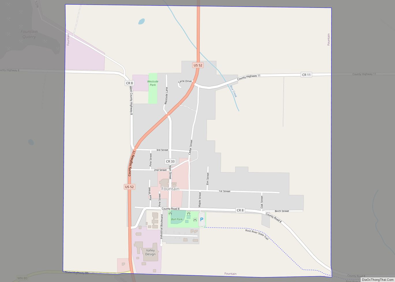
Fountain is a city in Fillmore County, Minnesota, United States. The population was 410 at the 2010 census. Fountain is the western terminus of the Root River segment of the Root River State Trail. Local attractions include the Fillmore County History Center. Fountain city overview: Name: Fountain city LSAD Code: 25 LSAD Description: city (suffix) ... Read more
Map of Fountain city, Minnesota
Map of Fosston city
Fosston is a city in Polk County, Minnesota, United States. It is part of the Greater Grand Forks region. The population was 1,434 at the time of the 2020 census. Fosston city overview: Name: Fosston city LSAD Code: 25 LSAD Description: city (suffix) State: Minnesota County: Polk County Incorporated: 1889 Elevation: 1,293 ft (394 m) Total Area: ... Read more
Map of Fosston city
Map of Fort Ripley city
Fort Ripley is a city in Crow Wing County, Minnesota, United States, near the confluence of the Mississippi and Nokasippi Rivers. The population was 69 at the 2010 census. It is part of the Brainerd Micropolitan Statistical Area. Fort Ripley city overview: Name: Fort Ripley city LSAD Code: 25 LSAD Description: city (suffix) State: Minnesota ... Read more
Map of Fort Ripley city
Map of Foreston city
Foreston is a city in Mille Lacs County, Minnesota, United States. The population was 533 at the 2010 census. Foreston city overview: Name: Foreston city LSAD Code: 25 LSAD Description: city (suffix) State: Minnesota County: Mille Lacs County Elevation: 1,093 ft (333 m) Total Area: 1.44 sq mi (3.73 km²) Land Area: 1.43 sq mi (3.71 km²) Water Area: 0.01 sq mi (0.02 km²) Total Population: ... Read more
Map of Foreston city
Map of Forest Lake city, Minnesota
Forest Lake is a city in Washington County, Minnesota, United States, located 27 miles northeast of Saint Paul. The population was 20,611 at the 2020 census. The 2021 population is 20,608. Forest Lake city overview: Name: Forest Lake city LSAD Code: 25 LSAD Description: city (suffix) State: Minnesota County: Washington County Elevation: 935 ft (285 m) Total ... Read more
Map of Forest Lake city, Minnesota
Map of Fridley city
Fridley is a city in Anoka County, Minnesota, United States. Its population was 29,590 at the 2020 census. Fridley was incorporated in 1949 as a village, and became a city in 1957. It is part of the Minneapolis–Saint Paul metropolitan area as a “first-ring” or “inner-ring” suburb its northern part. Fridley borders Minneapolis to the ... Read more
Map of Fridley city
Map of Gary city, Minnesota
Gary is a city in Norman County, Minnesota, United States. The population was 227 at the 2020 census. Gary city overview: Name: Gary city LSAD Code: 25 LSAD Description: city (suffix) State: Minnesota County: Norman County Elevation: 1,099 ft (335 m) Total Area: 0.32 sq mi (0.83 km²) Land Area: 0.32 sq mi (0.83 km²) Water Area: 0.00 sq mi (0.00 km²) Total Population: 227 Population ... Read more
Map of Gary city, Minnesota
Map of Garvin city, Minnesota
Garvin is a city in Lyon County, Minnesota, United States. The population was 135 at the 2010 census. Garvin city overview: Name: Garvin city LSAD Code: 25 LSAD Description: city (suffix) State: Minnesota County: Lyon County Elevation: 1,539 ft (469 m) Total Area: 0.29 sq mi (0.75 km²) Land Area: 0.28 sq mi (0.72 km²) Water Area: 0.01 sq mi (0.03 km²) Total Population: 124 Population ... Read more
Map of Garvin city, Minnesota
Map of Garrison city, Minnesota
Garrison is a city in Crow Wing County, Minnesota, United States, along Mille Lacs Lake. The population was 210 at the 2010 census. It is part of the Brainerd Micropolitan Statistical Area. U.S. Highway 169 and Minnesota State Highway 18 are the main routes in the community. Garrison city overview: Name: Garrison city LSAD Code: ... Read more
Map of Garrison city, Minnesota
Map of Garfield city, Minnesota
Garfield is a city in Douglas County, Minnesota, United States. The population was 349 at the 2020 census. Garfield city overview: Name: Garfield city LSAD Code: 25 LSAD Description: city (suffix) State: Minnesota County: Douglas County Elevation: 1,424 ft (434 m) Total Area: 0.81 sq mi (2.10 km²) Land Area: 0.81 sq mi (2.09 km²) Water Area: 0.01 sq mi (0.02 km²) Total Population: 349 Population ... Read more
Map of Garfield city, Minnesota
Map of Garden City CDP, Minnesota
Garden City is an unincorporated community and census-designated place (CDP) in Garden City Township, Blue Earth County, Minnesota, United States. Its population was 255 as of the 2010 census. Garden City CDP overview: Name: Garden City CDP LSAD Code: 57 LSAD Description: CDP (suffix) State: Minnesota County: Blue Earth County Elevation: 919 ft (280 m) Total Area: ... Read more
Map of Garden City CDP, Minnesota
Map of Funkley city
Funkley is a city in Beltrami County, Minnesota, United States. The population was 18 at the 2020 census, making the city the second-least populous incorporated place in Minnesota. It shared that distinction with Tenney until the latter dissolved in 2011. Funkley was incorporated in 1904 at the site of a junction along the Minnesota and ... Read more
Map of Funkley city