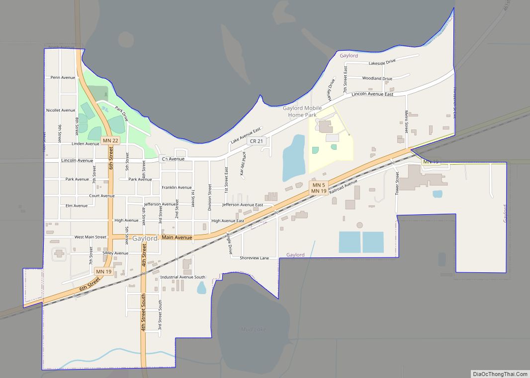
Map of Gilman city, Minnesota
Gilman is a city in Benton County, Minnesota, United States. The population was 224 at the 2010 census. It is part of the St. Cloud Metropolitan Statistical Area. Gilman city overview: Name: Gilman city LSAD Code: 25 LSAD Description: city (suffix) State: Minnesota County: Benton County Elevation: 1,191 ft (363 m) Total Area: 0.48 sq mi (1.24 km²) Land Area: ... Read more
Map of Gilman city, Minnesota
Map of Graceville city, Minnesota
Graceville is a city in Big Stone County, Minnesota, United States. The population was 529 at the 2020 census. Graceville city overview: Name: Graceville city LSAD Code: 25 LSAD Description: city (suffix) State: Minnesota County: Big Stone County Elevation: 1,112 ft (339 m) Total Area: 0.58 sq mi (1.50 km²) Land Area: 0.58 sq mi (1.50 km²) Water Area: 0.00 sq mi (0.00 km²) Total Population: ... Read more
Map of Graceville city, Minnesota
Map of Goodview city
Goodview is a city in Winona County, Minnesota, United States. The population was 4,158 at the 2020 census. Goodview city overview: Name: Goodview city LSAD Code: 25 LSAD Description: city (suffix) State: Minnesota County: Winona County Elevation: 669 ft (204 m) Total Area: 2.48 sq mi (6.41 km²) Land Area: 2.22 sq mi (5.75 km²) Water Area: 0.26 sq mi (0.67 km²) Total Population: 4,158 Population ... Read more
Map of Goodview city
Map of Goodridge city
Goodridge is a small city in Pennington County, Minnesota, United States. The population was 112 at the 2020 census. The city is located within Goodridge Township, but is politically independent. Goodridge city overview: Name: Goodridge city LSAD Code: 25 LSAD Description: city (suffix) State: Minnesota County: Pennington County Elevation: 1,171 ft (357 m) Total Area: 0.19 sq mi (0.49 km²) ... Read more
Map of Goodridge city
Map of Goodhue city
Goodhue is a city in Goodhue County, Minnesota, United States. The population was 1,176 at the 2010 census. Goodhue city overview: Name: Goodhue city LSAD Code: 25 LSAD Description: city (suffix) State: Minnesota County: Goodhue County Elevation: 1,122 ft (342 m) Total Area: 1.10 sq mi (2.85 km²) Land Area: 1.10 sq mi (2.85 km²) Water Area: 0.00 sq mi (0.00 km²) Total Population: 1,250 Population ... Read more
Map of Goodhue city
Map of Good Thunder city
Good Thunder is a city in Blue Earth County, Minnesota, United States, situated along the Maple River. The population was 560 at the 2020 census. It is part of the Mankato–North Mankato Metropolitan Statistical Area. Good Thunder city overview: Name: Good Thunder city LSAD Code: 25 LSAD Description: city (suffix) State: Minnesota County: Blue Earth ... Read more
Map of Good Thunder city
Map of Gonvick city
Gonvick is a city in Clearwater County, Minnesota, United States. The population was 263 at the 2020 census. Its peak population was 375 in 1950. Gonvick city overview: Name: Gonvick city LSAD Code: 25 LSAD Description: city (suffix) State: Minnesota County: Clearwater County Elevation: 1,283 ft (391 m) Total Area: 1.31 sq mi (3.39 km²) Land Area: 1.31 sq mi (3.39 km²) Water ... Read more
Map of Gonvick city
Map of Golden Valley city, Minnesota
Golden Valley is a western and first-ring suburb of Minneapolis in Hennepin County, Minnesota, United States. The population was 22,552 at the 2020 census. The city is mostly residential and is bordered by U.S. Highway 12 (Interstate 394). Over 15% of the city is parks or nature reserves. The Floyd B. Olson Memorial Highway also ... Read more
Map of Golden Valley city, Minnesota
Map of Glyndon city
Glyndon (/ˈɡlɪndən/ GLIN-dən) is a city in Clay County, Minnesota, United States. The population was 1,306 as of the 2020 census. Glyndon city overview: Name: Glyndon city LSAD Code: 25 LSAD Description: city (suffix) State: Minnesota County: Clay County Founded: 1872 Elevation: 925 ft (282 m) Total Area: 1.58 sq mi (4.10 km²) Land Area: 1.58 sq mi (4.10 km²) Water Area: 0.00 sq mi ... Read more
Map of Glyndon city
Map of Glenwood city, Minnesota
Glenwood is a city in, and the county seat of, Pope County, Minnesota, United States. The population was 2,657 at the 2020 census. It is located on the northeastern shore of Lake Minnewaska. Glenwood city overview: Name: Glenwood city LSAD Code: 25 LSAD Description: city (suffix) State: Minnesota County: Pope County Elevation: 1,161 ft (354 m) Total ... Read more
Map of Glenwood city, Minnesota
Map of Glenville city, Minnesota
Glenville is a city in Freeborn County, Minnesota, United States, near Albert Lea. It is along the Shell Rock River. The population was 643 at the 2010 census. Glenville city overview: Name: Glenville city LSAD Code: 25 LSAD Description: city (suffix) State: Minnesota County: Freeborn County Elevation: 1,234 ft (376 m) Total Area: 1.11 sq mi (2.88 km²) Land Area: ... Read more
Map of Glenville city, Minnesota
Map of Grand Rapids city, Minnesota
Grand Rapids is a city in Itasca County, Minnesota, United States, and it is the county seat. The population was 11,126 at the 2020 census. The city is named for the 3.5-mile (5.6 km) long rapids in the Mississippi River which was the uppermost limit of practical steamboat travel during the late 19th century. Today the ... Read more
Map of Grand Rapids city, Minnesota