Map of Jackson city, Minnesota
Jackson is a city and county seat of Jackson County, Minnesota, United States. The population was 3,299 at the 2010 census. Jackson city overview: Name: Jackson city LSAD Code: 25 LSAD Description: city (suffix) State: Minnesota County: Jackson County Elevation: 1,316 ft (401 m) Total Area: 5.22 sq mi (13.53 km²) Land Area: 5.19 sq mi (13.45 km²) Water Area: 0.03 sq mi (0.08 km²) Total ... Read more
Map of Jackson city, Minnesota
Map of Ivanhoe city, Minnesota
Ivanhoe is a city in Lincoln County, Minnesota, United States. The population was 559 at the 2010 census. Since 1902 it has been the county seat of Lincoln County and is now the least populous county seat in Minnesota. Ivanhoe city overview: Name: Ivanhoe city LSAD Code: 25 LSAD Description: city (suffix) State: Minnesota County: ... Read more
Map of Ivanhoe city, Minnesota
Map of Isle city
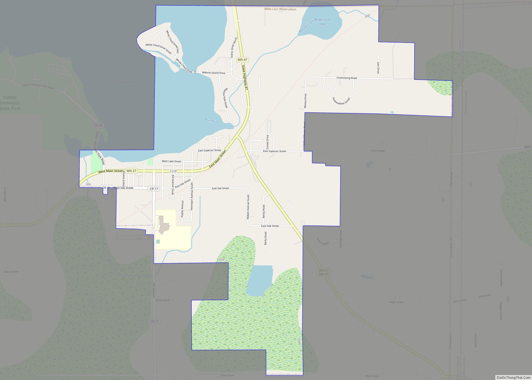
Isle is a city in Mille Lacs County, Minnesota, United States. The population was 751 at the 2010 census. Isle city overview: Name: Isle city LSAD Code: 25 LSAD Description: city (suffix) State: Minnesota County: Mille Lacs County Elevation: 1,276 ft (389 m) Total Area: 3.13 sq mi (8.12 km²) Land Area: 2.70 sq mi (6.99 km²) Water Area: 0.44 sq mi (1.13 km²) Total Population: ... Read more
Map of Isle city
Map of Isanti city
Isanti (/aɪˈsænti/ eye-SAN-tee) is a city in Isanti County, Minnesota, United States. The population was 6,804 at the 2020 census. The name Isanti is composed of two Dakota words: isan (“knife”) and ati (“camp”), and refers to the Santee Dakota people. Minnesota State Highway 65 and Isanti County Road 5 are the main routes in ... Read more
Map of Isanti city
Map of Ironton city, Minnesota
Ironton is a city in Crow Wing County, Minnesota, United States. The population was 572 at the 2010 census. It is part of the Brainerd Micropolitan Statistical Area. Ironton is on the Cuyuna iron range, from which its name is derived. It is immediately adjacent to its twin city of Crosby. Ironton city overview: Name: ... Read more
Map of Ironton city, Minnesota
Map of Keewatin city
Keewatin (/kiˈwɑːtɪn/ kee-WAH-tin) is a city in Itasca County, Minnesota, United States. The population was 1,068 at the 2010 census. U.S. Highway 169 serves as a main route in Keewatin. Students from the Keewatin area attend Nashwauk Keewatin High School. Keewatin city overview: Name: Keewatin city LSAD Code: 25 LSAD Description: city (suffix) State: Minnesota ... Read more
Map of Keewatin city
Map of Kasson city
Kasson (/ˈkæsən/ KASS-ən) is a city in Dodge County, Minnesota, United States. The population was 6,851 at the 2020 census. The city is located 13 miles (21 km) west of Rochester along U.S. Highway 14 and is one of the endpoints of Minnesota State Highway 57. The Dakota, Minnesota and Eastern Railroad’s main freight rail line ... Read more
Map of Kasson city
Map of Kasota city
Kasota is a city within the larger Kasota Township, Le Sueur County, Minnesota, United States. The population was 714 at the 2020 census. Kasota city overview: Name: Kasota city LSAD Code: 25 LSAD Description: city (suffix) State: Minnesota County: Le Sueur County Elevation: 807 ft (246 m) Total Area: 1.28 sq mi (3.32 km²) Land Area: 1.24 sq mi (3.22 km²) Water Area: ... Read more
Map of Kasota city
Map of Karlstad city
Karlstad (/ˈkɑːrlstæd/ KARL-stad) is a city in Kittson County, Minnesota, United States. The population was 710 at the 2020 census. U.S. Route 59 and Minnesota State Highway 11 are two of the main arterial routes in the city. The city’s slogan is “The Moose Capital of the North”. Karlstad city overview: Name: Karlstad city LSAD ... Read more
Map of Karlstad city
Map of Kandiyohi city
Kandiyohi (/ˌkændiˈjoʊhaɪ/ KAN-dee-YOH-hy) is a city in Kandiyohi County, Minnesota, United States. The population was 491 at the 2010 census. Kandiyohi city overview: Name: Kandiyohi city LSAD Code: 25 LSAD Description: city (suffix) State: Minnesota County: Kandiyohi County Elevation: 1,224 ft (373 m) Total Area: 0.39 sq mi (1.01 km²) Land Area: 0.39 sq mi (1.01 km²) Water Area: 0.00 sq mi (0.00 km²) Total Population: ... Read more
Map of Kandiyohi city
Map of Jordan city, Minnesota
Jordan is a city in Scott County, Minnesota, United States. The population was 6,656 at the 2020 census. Jordan city overview: Name: Jordan city LSAD Code: 25 LSAD Description: city (suffix) State: Minnesota County: Scott County Founded: 1853 Incorporated: 1891 Elevation: 771 ft (235 m) Total Area: 3.29 sq mi (8.53 km²) Land Area: 3.27 sq mi (8.47 km²) Water Area: 0.02 sq mi (0.06 km²) ... Read more
Map of Jordan city, Minnesota
Map of Kenneth city
Kenneth is a city in Rock County, Minnesota, United States. The population was 68 at the 2010 census. Kenneth city overview: Name: Kenneth city LSAD Code: 25 LSAD Description: city (suffix) State: Minnesota County: Rock County Elevation: 1,575 ft (480 m) Total Area: 1.06 sq mi (2.75 km²) Land Area: 1.06 sq mi (2.75 km²) Water Area: 0.00 sq mi (0.00 km²) Total Population: 60 Population ... Read more
Map of Kenneth city