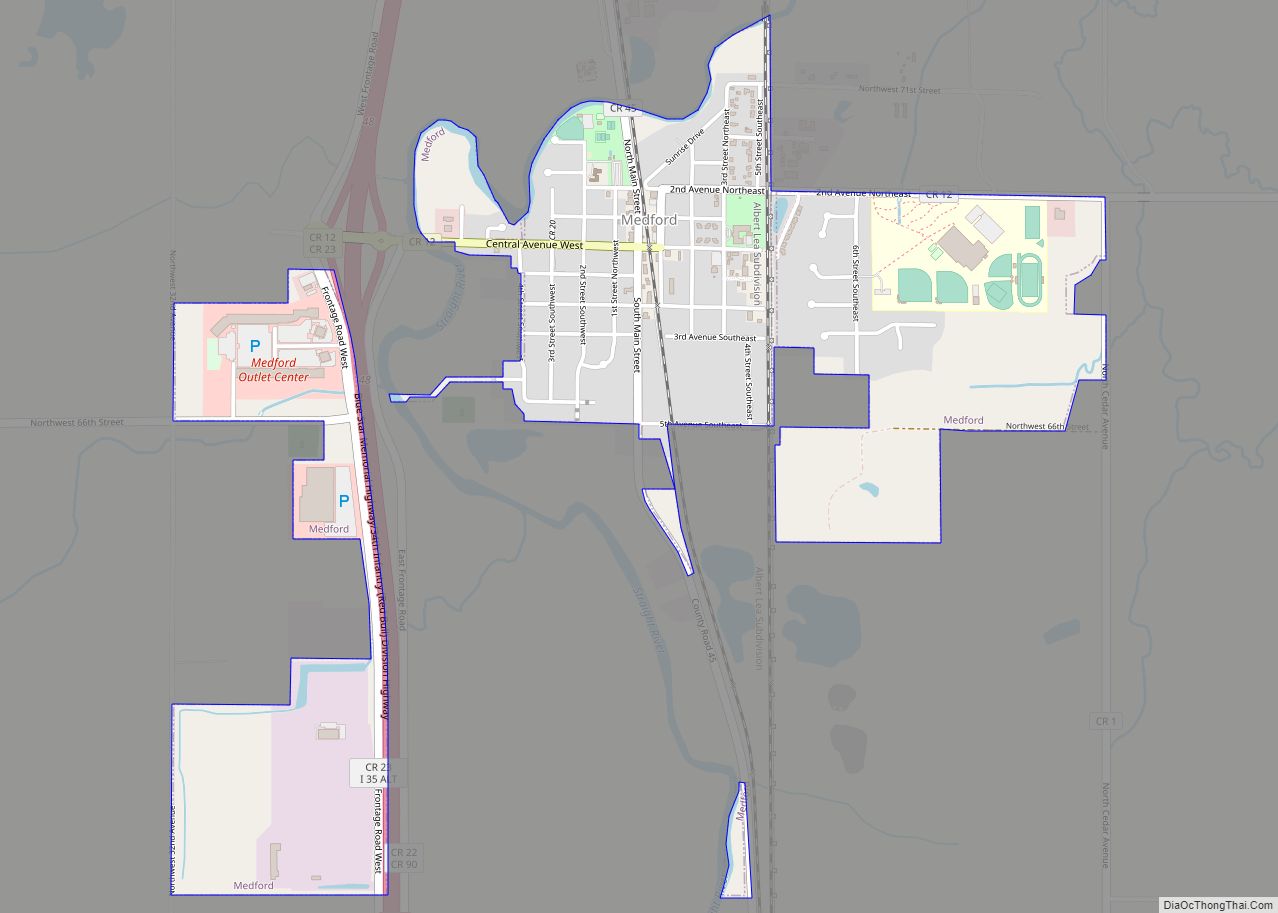
Map of McIntosh city, Minnesota
McIntosh (/ˈmækɪntɒʃ/ MAK-in-tosh) is a city in Polk County, Minnesota, United States. It is part of the Grand Forks, ND–MN Metropolitan Statistical Area. The population was 606 at the 2020 census. McIntosh city overview: Name: McIntosh city LSAD Code: 25 LSAD Description: city (suffix) State: Minnesota County: Polk County Founded: 1883 Elevation: 1,234 ft (376 m) Total ... Read more
Map of McIntosh city, Minnesota
Map of McGregor city, Minnesota
McGregor is a city in Aitkin County, Minnesota, United States. The population was 391 at the 2010 census. McGregor is located along Minnesota State Highways 65 and 210. Other routes include Aitkin County Road 8, Maddy Street. McGregor city overview: Name: McGregor city LSAD Code: 25 LSAD Description: city (suffix) State: Minnesota County: Aitkin County ... Read more
Map of McGregor city, Minnesota
Map of Menahga city
Menahga (/məˈnɑːɡə/ mə-NAH-gə) is a city in Wadena County in the U.S. state of Minnesota The population was 1,306 at the 2010 census. Menahga city overview: Name: Menahga city LSAD Code: 25 LSAD Description: city (suffix) State: Minnesota County: Wadena County Elevation: 1,401 ft (427 m) Total Area: 3.90 sq mi (10.11 km²) Land Area: 3.71 sq mi (9.61 km²) Water Area: 0.19 sq mi ... Read more
Map of Menahga city
Map of Melrose city, Minnesota
Melrose is a city in Stearns County, Minnesota, United States. The population was 3,598 at the 2010 census. It is part of the St. Cloud Metropolitan Statistical Area. Melrose city overview: Name: Melrose city LSAD Code: 25 LSAD Description: city (suffix) State: Minnesota County: Stearns County Elevation: 1,204 ft (367 m) Total Area: 3.30 sq mi (8.56 km²) Land Area: ... Read more
Map of Melrose city, Minnesota
Map of Meire Grove city
Meire Grove (/ˈmaɪər ˈɡroʊv/ MIRE GROHV) is a city in Stearns County, Minnesota, United States. The population was 179 at the 2010 census. It is part of the St. Cloud Metropolitan Statistical Area. Minnesota State Highway 4 serves as a main route in the community, and Interstate 94/U.S. Highway 52 is nearby. Meire Grove city ... Read more
Map of Meire Grove city
Map of Millerville city, Minnesota
Millerville is a city in Douglas County, Minnesota, United States. The population was 100 at the 2020 census. Millerville city overview: Name: Millerville city LSAD Code: 25 LSAD Description: city (suffix) State: Minnesota County: Douglas County Elevation: 1,394 ft (425 m) Total Area: 0.86 sq mi (2.23 km²) Land Area: 0.86 sq mi (2.23 km²) Water Area: 0.00 sq mi (0.00 km²) Total Population: 100 Population ... Read more
Map of Millerville city, Minnesota
Map of Milan city, Minnesota
Milan (/ˈmaɪlən/ MY-lən) is a city in Chippewa County, Minnesota, United States. The population was 369 at the 2010 census. Milan city overview: Name: Milan city LSAD Code: 25 LSAD Description: city (suffix) State: Minnesota County: Chippewa County Elevation: 1,030 ft (310 m) Total Area: 0.70 sq mi (1.80 km²) Land Area: 0.68 sq mi (1.77 km²) Water Area: 0.01 sq mi (0.03 km²) Total Population: ... Read more
Map of Milan city, Minnesota
Map of Milaca city
Milaca (/mɪˈlækə/ mi-LAK-ə) is a city and the county seat of Mille Lacs County, Minnesota. The population was 2,946 at the time of the 2010 census. It is situated on the Rum River. Milaca city overview: Name: Milaca city LSAD Code: 25 LSAD Description: city (suffix) State: Minnesota County: Mille Lacs County Elevation: 1,079 ft (329 m) ... Read more
Map of Milaca city
Map of Miesville city
Miesville (/ˈmiːzvɪl/ MEEZ-vil) is a city in Dakota County, Minnesota, United States. The population was 125 at the 2010 census. U.S. Highway 61 serves as a main route in the community. Minnesota Highways 20, 50, and 316 are nearby. Miesville is home to an amateur baseball team, the Miesville Mudhens, which participate in Town Team ... Read more
Map of Miesville city
Map of Midway CDP, Minnesota
Midway is a census-designated place and unincorporated community in La Garde Township, Mahnomen County, Minnesota, United States. Its population was 26 as of the 2010 census. Midway CDP overview: Name: Midway CDP LSAD Code: 57 LSAD Description: CDP (suffix) State: Minnesota County: Mahnomen County Elevation: 1,342 ft (409 m) Total Area: 2.01 sq mi (5.21 km²) Land Area: 1.85 sq mi (4.80 km²) ... Read more
Map of Midway CDP, Minnesota
Map of Middle River city, Minnesota
Middle River is a city in Marshall County, Minnesota, United States, along the Middle River, from which the city took its name. The population was 304 at the 2020 census. Middle River city overview: Name: Middle River city LSAD Code: 25 LSAD Description: city (suffix) State: Minnesota County: Marshall County Elevation: 1,142 ft (348 m) Total Area: ... Read more
Map of Middle River city, Minnesota
Map of Merrifield CDP, Minnesota
Merrifield is an unincorporated community and census-designated place (CDP) in Lake Edward Township, Crow Wing County, Minnesota, United States, near Brainerd. It is along Crow Wing County Road 3 near County Road 127. Its population was 140 as of the 2010 census. Merrifield CDP overview: Name: Merrifield CDP LSAD Code: 57 LSAD Description: CDP (suffix) ... Read more
Map of Merrifield CDP, Minnesota