Map of Paynesville city, Minnesota
Paynesville is a city in Stearns County, Minnesota, United States, on Lake Koronis, in the central part of the state. The population was 2,388 at the 2020 census. It is part of the St. Cloud Metropolitan Statistical Area. Paynesville city overview: Name: Paynesville city LSAD Code: 25 LSAD Description: city (suffix) State: Minnesota County: Stearns ... Read more
Map of Paynesville city, Minnesota
Map of Parkers Prairie city
Parkers Prairie is a city in Otter Tail County, Minnesota, United States. The population was 1,020 at the 2020 census. Parkers Prairie city overview: Name: Parkers Prairie city LSAD Code: 25 LSAD Description: city (suffix) State: Minnesota County: Otter Tail County Founded: 1880 Elevation: 1,470 ft (448 m) Total Area: 1.25 sq mi (3.24 km²) Land Area: 1.25 sq mi (3.23 km²) Water ... Read more
Map of Parkers Prairie city
Map of Park Rapids city
Park Rapids is a city in and the county seat of Hubbard County, Minnesota, United States. It is near Itasca State Park, the source of the Mississippi River, as well as the beginning of the Heartland State Trail. The city was founded in 1890 near the Fish Hook River rapids and is along U.S. Highway ... Read more
Map of Park Rapids city
Map of Palisade city, Minnesota
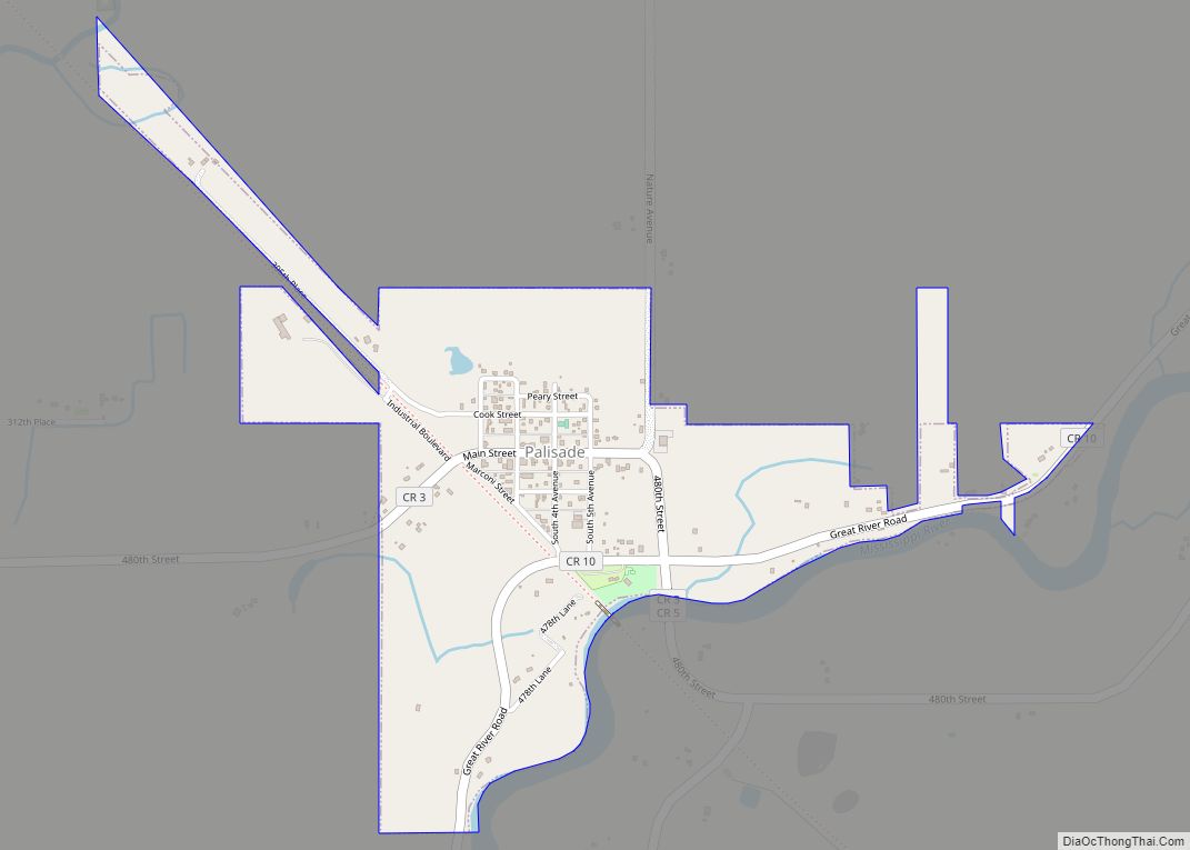
Palisade is a city in Aitkin County, Minnesota, United States. The population was 167 at the 2010 census. The Mississippi River flows through the area. Palisade city overview: Name: Palisade city LSAD Code: 25 LSAD Description: city (suffix) State: Minnesota County: Aitkin County Incorporated: July 7, 1922 Elevation: 1,237 ft (377 m) Total Area: 0.69 sq mi (1.78 km²) Land ... Read more
Map of Palisade city, Minnesota
Map of Owatonna city
Owatonna (/ˌoʊwəˈtɒnə/ OH-wə-TON-ə) is a city in Steele County, Minnesota, United States. The population was 26,420 at the 2020 census. It is the county seat of Steele County. Owatonna is home to the Steele County Fairgrounds, which hosts the Steele County Free Fair in August. Interstate 35 and U.S. Highways 14, and 218 are three ... Read more
Map of Owatonna city
Map of Ottertail city
Ottertail is a city in Otter Tail County, Minnesota, United States. The population was 629 at the 2020 census. Ottertail city overview: Name: Ottertail city LSAD Code: 25 LSAD Description: city (suffix) State: Minnesota County: Otter Tail County Founded: 1903 Elevation: 1,352 ft (412 m) Total Area: 5.97 sq mi (15.47 km²) Land Area: 4.28 sq mi (11.08 km²) Water Area: 1.70 sq mi (4.39 km²) ... Read more
Map of Ottertail city
Map of Otsego city, Minnesota
Otsego (/ɒtˈsiːɡoʊ/ ot-SEE-goh) is a city in Wright County, Minnesota, United States. It is a northwest suburb within the Minneapolis–Saint Paul metropolitan area. It had a population of 19,966 at the 2020 census. Following the 2020 census, Otsego was determined to be the largest city in Wright County, and the 60th largest in Minnesota. Minnesota ... Read more
Map of Otsego city, Minnesota
Map of Ostrander city, Minnesota
Ostrander (/oʊstˈrændɜːr/ ohst-RAND-ər) is a city in Fillmore County, Minnesota, United States. The population was 254 at the 2010 census. Ostrander city overview: Name: Ostrander city LSAD Code: 25 LSAD Description: city (suffix) State: Minnesota County: Fillmore County Elevation: 1,345 ft (410 m) Total Area: 0.47 sq mi (1.23 km²) Land Area: 0.47 sq mi (1.23 km²) Water Area: 0.00 sq mi (0.00 km²) Total Population: ... Read more
Map of Ostrander city, Minnesota
Map of Peterson city, Minnesota
Peterson is a city in Fillmore County, Minnesota, United States. The population was 199 at the 2010 census. Peterson city overview: Name: Peterson city LSAD Code: 25 LSAD Description: city (suffix) State: Minnesota County: Fillmore County Elevation: 761 ft (232 m) Total Area: 0.49 sq mi (1.28 km²) Land Area: 0.47 sq mi (1.23 km²) Water Area: 0.02 sq mi (0.05 km²) Total Population: 234 Population ... Read more
Map of Peterson city, Minnesota
Map of Osseo city, Minnesota
Osseo (/ˈɑːsiˌoʊ/ AH-see-oh) is a small city in Hennepin County, Minnesota, United States. As of the 2020 census it had a population of 2,688. It is said that “Osseo” derives from the Ojibwe name waaseyaa meaning “there is light” (more commonly translated as “Son of the Evening Star”). Henry Wadsworth Longfellow mentions Osseo in his ... Read more
Map of Osseo city, Minnesota
Map of Perley city
Perley is a city in Norman County, Minnesota, United States. Its population was 113 at the 2020 census. Perley city overview: Name: Perley city LSAD Code: 25 LSAD Description: city (suffix) State: Minnesota County: Norman County Elevation: 876 ft (267 m) Total Area: 0.25 sq mi (0.64 km²) Land Area: 0.25 sq mi (0.64 km²) Water Area: 0.00 sq mi (0.00 km²) Total Population: 113 Population ... Read more
Map of Perley city
Map of Oslo city
Oslo is a city in Marshall County, Minnesota, United States. The population was 239 at the 2020 census. Minnesota Highway 1 and Minnesota Highway 220 are two of the main routes in the community. Oslo is three miles east of Interstate 29 in nearby North Dakota. Oslo city overview: Name: Oslo city LSAD Code: 25 ... Read more
Map of Oslo city