Map of Walters city

Map of Walters city, Minnesota

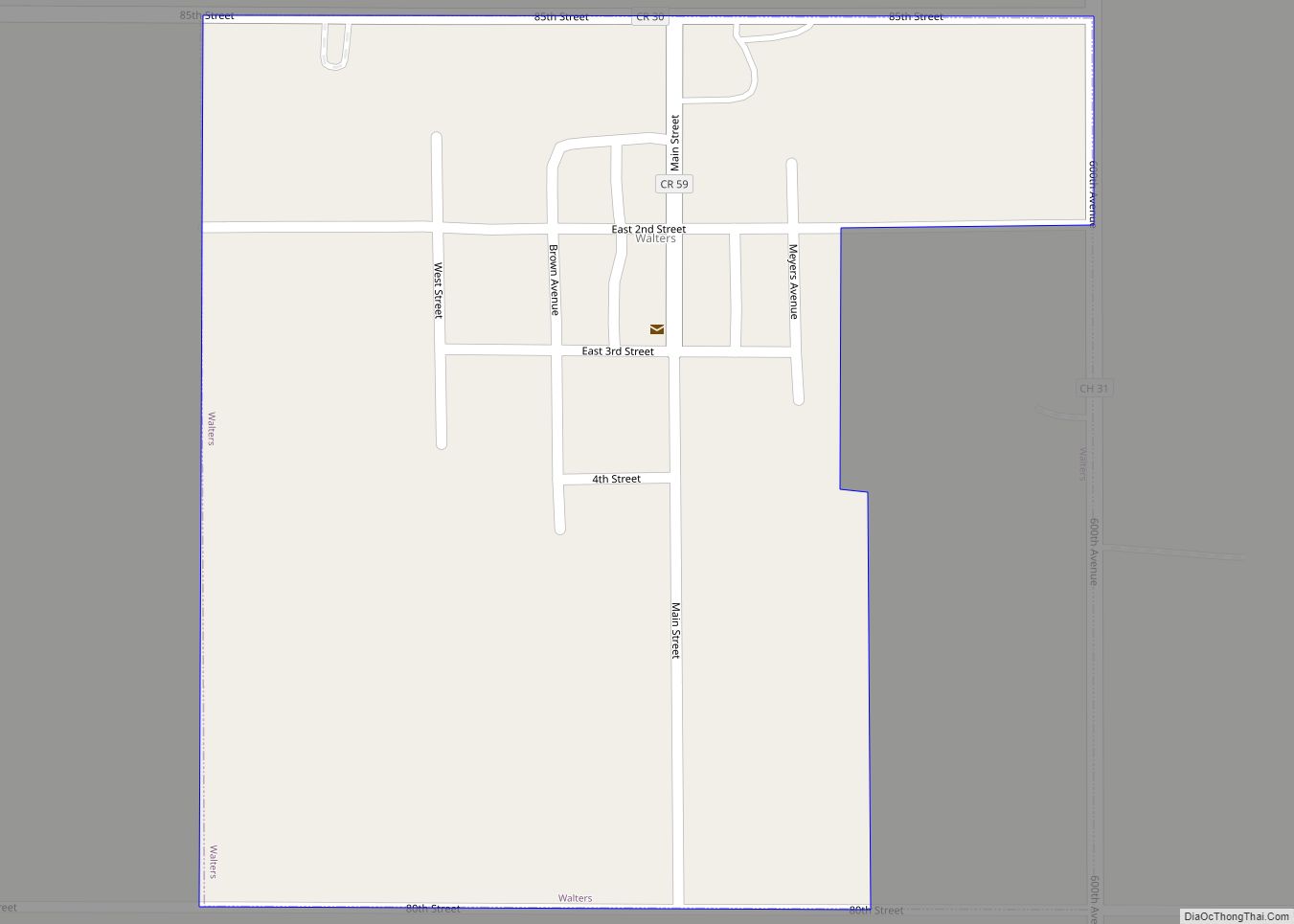
Walters is a city in Faribault County, Minnesota, United States. The population was 73 at the 2010 census. Walters city overview: Name: Walters city LSAD Code: 25 LSAD Description: city (suffix) State: Minnesota County: Faribault County Elevation: 1,257 ft (383 m) Total Area: 0.20 sq mi (0.52 km²) Land Area: 0.20 sq mi (0.52 km²) Water Area: 0.00 sq mi (0.00 km²) Total Population: 69 Population … Read more

Map of Wanda city

Map of Wanda city

Wanda is a city in Redwood County, Minnesota, United States. The population was 84 at the 2010 census. Wanda is in the southwest quadrant of Minnesota. Wanda city overview: Name: Wanda city LSAD Code: 25 LSAD Description: city (suffix) State: Minnesota County: Redwood County Elevation: 1,093 ft (333 m) Total Area: 0.26 sq mi (0.68 km²) Land Area: 0.26 sq mi (0.67 km²) … Read more

Map of Warren city, Minnesota

Map of Warren city, Minnesota

Warren is a city in and the county seat of Marshall County, Minnesota, United States. The population was 1,605 at the 2020 census. Warren city overview: Name: Warren city LSAD Code: 25 LSAD Description: city (suffix) State: Minnesota County: Marshall County Founded: 1879 Elevation: 856 ft (261 m) Total Area: 1.46 sq mi (3.77 km²) Land Area: 1.46 sq mi (3.77 km²) Water … Read more

Map of Warba city

Map of Warba city

Warba is a city in Itasca County, Minnesota, United States. The population was 181 at the 2010 census. U.S. Highway 2 serves as a main route in the community. Warba city overview: Name: Warba city LSAD Code: 25 LSAD Description: city (suffix) State: Minnesota County: Itasca County Elevation: 1,283 ft (391 m) Total Area: 3.28 sq mi (8.49 km²) Land … Read more

Map of Waseca city

Map of Waseca city

Waseca (/wəˈsiːkə/) is a city in Waseca County, Minnesota, United States. The population was 9,410 at the 2010 census. It is the county seat. Waseca city overview: Name: Waseca city LSAD Code: 25 LSAD Description: city (suffix) State: Minnesota County: Waseca County Elevation: 1,152 ft (351 m) Total Area: 5.47 sq mi (14.17 km²) Land Area: 4.29 sq mi (11.11 km²) Water Area: … Read more

Map of Warsaw CDP, Minnesota

Map of Warsaw CDP, Minnesota

Warsaw is an unincorporated community and census-designated place (CDP) in Warsaw Township, Rice County, Minnesota, United States. As of the 2010 census, its population was 627. The community is located east of Morristown and west of Faribault. Warsaw is located at the junction of State Highway 60 (MN 60) and Rice County Road 13 (Farwell … Read more

Map of Warroad city

Map of Warroad city

Warroad is a city in Roseau County, Minnesota, United States, at the southwest corner of Lake of the Woods, 7.5 miles (12.1 km) south of Canada. The population was 1,781 at the 2010 census. Warroad had its own newspaper before it was incorporated in 1901. Minnesota State Highways 11 and 313 are two of the city’s … Read more

Map of Watkins city, Minnesota

Map of Watkins city, Minnesota

Watkins is a city in Meeker County, Minnesota, United States. The population was 962 at the 2010 census. Watkins city overview: Name: Watkins city LSAD Code: 25 LSAD Description: city (suffix) State: Minnesota County: Meeker County Elevation: 1,158 ft (353 m) Total Area: 0.69 sq mi (1.78 km²) Land Area: 0.69 sq mi (1.78 km²) Water Area: 0.00 sq mi (0.00 km²) Total Population: 991 Population … Read more

Map of Waterville city, Minnesota

Map of Waterville city, Minnesota

Waterville is a town in Le Sueur County, Minnesota, United States. The population was 1,868 at the 2010 census. It is close to Sakatah Lake State Park on the Cannon River. Waterville has a yearly celebration called “Bullhead Days,” and it is held in early June; the residents of the town get together for food, … Read more

Map of Watertown city, Minnesota

Map of Watertown city, Minnesota

Watertown is a small city in Carver County, Minnesota, United States, along the South Fork of the Crow River, on the outskirts of the Twin Cities metro area. The population was 4,659 at the 2020 census. Watertown city overview: Name: Watertown city LSAD Code: 25 LSAD Description: city (suffix) State: Minnesota County: Carver County Founded: … Read more

Map of Waverly city, Minnesota

Map of Waverly city, Minnesota

Waverly is a city in Wright County, Minnesota, United States. The population was 1,357 at the 2010 census. Waverly city overview: Name: Waverly city LSAD Code: 25 LSAD Description: city (suffix) State: Minnesota County: Wright County Elevation: 1,007 ft (307 m) Total Area: 2.53 sq mi (6.56 km²) Land Area: 1.66 sq mi (4.29 km²) Water Area: 0.88 sq mi (2.27 km²) Total Population: 1,900 Population … Read more

Map of Waubun city

Map of Waubun city

Waubun is a city in Mahnomen County, Minnesota, United States. The population was 400 at the 2010 census. U.S. Route 59 and Minnesota State Highway 113 are two of the main routes in the community. Waubun city overview: Name: Waubun city LSAD Code: 25 LSAD Description: city (suffix) State: Minnesota County: Mahnomen County Elevation: 1,240 ft … Read more