Map of Watson city, Minnesota

Map of Watson city, Minnesota

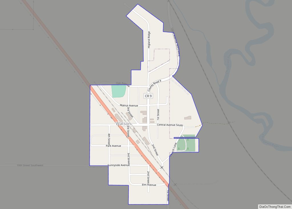
Watson is a city in Chippewa County, Minnesota, United States. The population was 205 at the 2010 census. Lac Qui Parle State Park is nearby. Watson city overview: Name: Watson city LSAD Code: 25 LSAD Description: city (suffix) State: Minnesota County: Chippewa County Elevation: 1,030 ft (310 m) Total Area: 0.17 sq mi (0.45 km²) Land Area: 0.17 sq mi (0.45 km²) Water … Read more

Map of Wells city

Map of Wells city, Minnesota

Wells is a city in Faribault County, Minnesota, United States. The population was 2,343 at the 2010 census. Wells city overview: Name: Wells city LSAD Code: 25 LSAD Description: city (suffix) State: Minnesota County: Faribault County Elevation: 1,155 ft (352 m) Total Area: 2.24 sq mi (5.79 km²) Land Area: 2.09 sq mi (5.41 km²) Water Area: 0.15 sq mi (0.38 km²) Total Population: 2,410 Population … Read more

Map of Welcome city, Minnesota

Map of Welcome city, Minnesota

Welcome is a city in Martin County, Minnesota, United States. The population was 686 at the 2010 census. The U.S. Census Bureau estimated 2018 population is 649. Welcome city overview: Name: Welcome city LSAD Code: 25 LSAD Description: city (suffix) State: Minnesota County: Martin County Elevation: 1,243 ft (379 m) Total Area: 1.46 sq mi (3.77 km²) Land Area: 1.46 sq mi … Read more

Map of Wayzata city

Map of Wayzata city

Wayzata (/waɪˈzɛtə/ wy-ZET-ə) is a city in Hennepin County, Minnesota, United States. A western suburb of the Twin Cities, Wayzata is situated along the northern shore of Lake Minnetonka about 12 miles (19 km) west of Minneapolis. Known for its small-town character and lakeside location, Wayzata is frequented by local boaters, shoppers, and restaurant goers. The … Read more

Map of West Concord city, Minnesota

Map of West Concord city, Minnesota

West Concord is a city in Dodge County, Minnesota, United States. The population was 861 at the 2020 census. West Concord city overview: Name: West Concord city LSAD Code: 25 LSAD Description: city (suffix) State: Minnesota County: Dodge County Elevation: 1,230 ft (375 m) Total Area: 1.08 sq mi (2.79 km²) Land Area: 1.07 sq mi (2.78 km²) Water Area: 0.00 sq mi (0.00 km²) Total … Read more

Map of Wendell city, Minnesota

Map of Wendell city, Minnesota

Wendell is a city in Grant County, Minnesota, United States. The population was 167 at the 2010 census. Wendell city overview: Name: Wendell city LSAD Code: 25 LSAD Description: city (suffix) State: Minnesota County: Grant County Elevation: 1,145 ft (349 m) Total Area: 0.99 sq mi (2.57 km²) Land Area: 0.99 sq mi (2.57 km²) Water Area: 0.00 sq mi (0.00 km²) Total Population: 166 Population … Read more

Map of West Roy Lake CDP

Map of West Roy Lake CDP

West Roy Lake is a census-designated place and unincorporated community in Twin Lakes Township, Mahnomen County, Minnesota, United States. Its population was 74 as of the 2010 census. West Roy Lake CDP overview: Name: West Roy Lake CDP LSAD Code: 57 LSAD Description: CDP (suffix) State: Minnesota County: Mahnomen County Elevation: 1,496 ft (456 m) Total Area: … Read more

Map of Westbrook city, Minnesota

Map of Westbrook city, Minnesota

Westbrook is a city in Cottonwood County, Minnesota, United States. The population was 739 at the 2010 census. Westbrook city overview: Name: Westbrook city LSAD Code: 25 LSAD Description: city (suffix) State: Minnesota County: Cottonwood County Elevation: 1,427 ft (435 m) Total Area: 0.67 sq mi (1.74 km²) Land Area: 0.67 sq mi (1.74 km²) Water Area: 0.00 sq mi (0.00 km²) Total Population: 758 Population … Read more

Map of West Union city, Minnesota

Map of West Union city, Minnesota

West Union is a city in Todd County, Minnesota, United States. The population was 111 at the 2010 census. West Union city overview: Name: West Union city LSAD Code: 25 LSAD Description: city (suffix) State: Minnesota County: Todd County Elevation: 1,339 ft (408 m) Total Area: 0.48 sq mi (1.24 km²) Land Area: 0.44 sq mi (1.15 km²) Water Area: 0.03 sq mi (0.09 km²) Total … Read more

Map of West St. Paul city

Map of West St. Paul city

West St. Paul is a city in Dakota County, Minnesota, United States. The population was 20,615 at the 2020 census. It is immediately south of Saint Paul and immediately west of South St. Paul. West St. Paul city overview: Name: West St. Paul city LSAD Code: 25 LSAD Description: city (suffix) State: Minnesota County: Dakota … Read more

Map of Wheaton city, Minnesota

Map of Wheaton city, Minnesota

Wheaton is a city in Traverse County, Minnesota, United States. The population was 1,460 at the 2020 census. It is the county seat. Wheaton city overview: Name: Wheaton city LSAD Code: 25 LSAD Description: city (suffix) State: Minnesota County: Traverse County Elevation: 1,020 ft (311 m) Total Area: 1.74 sq mi (4.50 km²) Land Area: 1.74 sq mi (4.50 km²) Water Area: 0.00 sq mi … Read more

Map of Whalan city

Map of Whalan city

Whalan is a city in Fillmore County, Minnesota, United States. The population was 63 at the 2010 census. Whalan city overview: Name: Whalan city LSAD Code: 25 LSAD Description: city (suffix) State: Minnesota County: Fillmore County Elevation: 791 ft (241 m) Total Area: 0.46 sq mi (1.18 km²) Land Area: 0.43 sq mi (1.11 km²) Water Area: 0.03 sq mi (0.07 km²) Total Population: 67 Population … Read more