Map of Hallsville city

Map of Hallsville city, Missouri

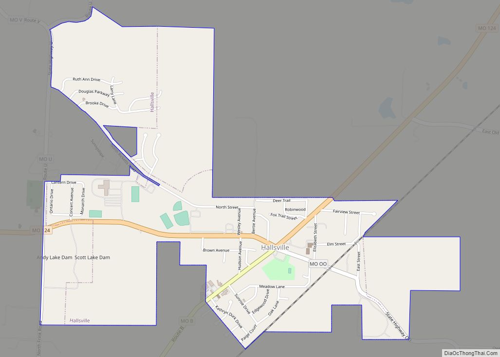
Hallsville is a city in Boone County, Missouri. It is part of the Columbia metropolitan area. The population was 1,614 at the time of the 2020 census. Southeast of the town is Mount Zion Church and Cemetery, the site of the Battle of Mount Zion Church during the Civil War. Hallsville city overview: Name: Hallsville … Read more

Map of Halfway village, Missouri

Map of Halfway village, Missouri

Halfway is a village in Polk County, Missouri, United States. According to the 2010 census, the population of Halfway is 173. It is part of the Springfield, Missouri Metropolitan Statistical Area. Halfway village overview: Name: Halfway village LSAD Code: 47 LSAD Description: village (suffix) State: Missouri County: Polk County Elevation: 1,063 ft (324 m) Total Area: 2.14 sq mi … Read more

Map of Hannibal city

Map of Hannibal city, Missouri

Hannibal is a city along the Mississippi River in Marion and Ralls counties in the U.S. state of Missouri. According to the 2020 U.S. Census, the population was 17,312, making it the largest city in Marion County. The bulk of the city is in Marion County, with a tiny sliver in the south extending into … Read more

Map of Hanley Hills village

Map of Hanley Hills village

Hanley Hills is a village in St. Louis County, Missouri, United States. The population was 2,101 at the 2010 census. Hanley Hills village overview: Name: Hanley Hills village LSAD Code: 47 LSAD Description: village (suffix) State: Missouri County: St. Louis County Elevation: 558 ft (170 m) Total Area: 0.36 sq mi (0.93 km²) Land Area: 0.36 sq mi (0.93 km²) Water Area: 0.00 sq mi … Read more

Map of Hamilton city, Missouri

Map of Hamilton city, Missouri

Hamilton is a city in northern Caldwell County, Missouri, and is part of the Kansas City metropolitan area within the United States. The population was 1,690 at the 2020 census. It is known as the hometown of James Cash Penney, who built a large apparel-related business, J. C. Penney, and the hometown of Jenny Doan, … Read more

Map of Harrisburg town, Missouri

Map of Harrisburg town, Missouri

Harrisburg is a village in western Boone County, Missouri, United States. It is part of the Columbia, Missouri Metropolitan Statistical Area. The population was 266 at the 2010 census. Harrisburg town overview: Name: Harrisburg town LSAD Code: 43 LSAD Description: town (suffix) State: Missouri County: Boone County Elevation: 817 ft (249 m) Total Area: 0.80 sq mi (2.08 km²) Land … Read more

Map of Harris town, Missouri

Map of Harris town, Missouri

Harris is a city in Sullivan County, Missouri, United States. The population was 61 at the 2010 census, at which time it was a town. Harris town overview: Name: Harris town LSAD Code: 43 LSAD Description: town (suffix) State: Missouri County: Sullivan County Elevation: 909 ft (277 m) Total Area: 0.15 sq mi (0.40 km²) Land Area: 0.15 sq mi (0.40 km²) Water … Read more

Map of Hardin city, Missouri

Map of Hardin city, Missouri

Hardin is a city in southeast Ray County, Missouri, and part of the Kansas City metropolitan area within the United States. The population was 571 at the 2020 census. Hardin city overview: Name: Hardin city LSAD Code: 25 LSAD Description: city (suffix) State: Missouri County: Ray County Elevation: 692 ft (211 m) Total Area: 0.64 sq mi (1.67 km²) Land … Read more

Map of Harrisonville city

Map of Harrisonville city

Harrisonville is a city in Cass County, Missouri, United States. The population was 10,121 at the 2020 census. It is the county seat of Cass County. It is part of the Kansas City metropolitan area. Harrisonville city overview: Name: Harrisonville city LSAD Code: 25 LSAD Description: city (suffix) State: Missouri County: Cass County Incorporated: 1851 … Read more

Map of Hartville city

Map of Hartville city, Missouri

Hartville is a city in Wright County, Missouri, United States. The population was 594 at the 2020 census. It is the county seat of Wright County. Hartville city overview: Name: Hartville city LSAD Code: 25 LSAD Description: city (suffix) State: Missouri County: Wright County Elevation: 1,191 ft (363 m) Total Area: 0.66 sq mi (1.72 km²) Land Area: 0.65 sq mi (1.69 km²) … Read more

Map of Hartsburg town, Missouri

Map of Hartsburg town, Missouri

Hartsburg is a village in southern Boone County, Missouri, United States. It is part of the Columbia, Missouri Metropolitan Statistical Area. The population was 133 per the 2020 census. Hartsburg town overview: Name: Hartsburg town LSAD Code: 43 LSAD Description: town (suffix) State: Missouri County: Boone County Elevation: 591 ft (180 m) Total Area: 0.21 sq mi (0.56 km²) Land … Read more

Map of Harwood village

Map of Harwood village, Missouri

Harwood is a village in northeast Vernon County, Missouri, United States. The population was 47 at the 2010 census. It was estimated to be 45 by the City of Harwood as of July 1, 2019. Harwood village overview: Name: Harwood village LSAD Code: 47 LSAD Description: village (suffix) State: Missouri County: Vernon County Elevation: 837 ft … Read more