Map of Lowry City city

Map of Lowry City

Lowry City is a city in St. Clair County, Missouri, United States. The population was 613 at the 2020 census. Lowry City is the city where the Ozark Mountains meet the Great Plains. Lowry City overview: Name: Lowry City LSAD Code: 25 LSAD Description: city (suffix) State: Missouri County: St. Clair County Elevation: 876 ft (267 m) … Read more

Map of Louisiana city

Map of Louisiana city

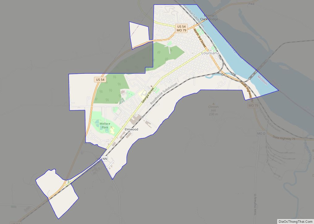
Louisiana is a city in Pike County, Missouri, United States. The population was 3,364 at the 2010 census. Louisiana is located in northeast Missouri, on the Mississippi River, south of Hannibal. Louisiana is located at the junction of State Route 79 and US 54. The former follows the Mississippi River for most of its length … Read more

Map of Lupus town

Map of Lupus town

Lupus is a city in Moniteau County, Missouri, United States. The population was 33 at the 2010 census. It is part of the Jefferson City, Missouri Metropolitan Statistical Area. Lupus town overview: Name: Lupus town LSAD Code: 43 LSAD Description: town (suffix) State: Missouri County: Moniteau County Incorporated: 1884 Elevation: 577 ft (176 m) Total Area: 0.18 sq mi … Read more

Map of Ludlow town, Missouri

Map of Ludlow town, Missouri

Ludlow is a village in southwest Livingston County, Missouri, United States. The population was 111 at the 2020 census. The median income in Ludlow is $30,833 and the median home value is $33,500. Ludlow town overview: Name: Ludlow town LSAD Code: 43 LSAD Description: town (suffix) State: Missouri County: Livingston County Elevation: 751 ft (229 m) Total … Read more

Map of Lucerne village, Missouri

Map of Lucerne village, Missouri

Lucerne is a village in western Putnam County, Missouri, United States. The population was 57 at the 2020 census. Lucerne village overview: Name: Lucerne village LSAD Code: 47 LSAD Description: village (suffix) State: Missouri County: Putnam County Elevation: 981 ft (299 m) Total Area: 0.25 sq mi (0.65 km²) Land Area: 0.25 sq mi (0.65 km²) Water Area: 0.00 sq mi (0.00 km²) Total Population: 57 … Read more

Map of Macon city, Missouri

Map of Macon city, Missouri

Macon is a city in and the county seat of Macon County, Missouri, United States. The population was 5,457 at the 2020 census. Macon city overview: Name: Macon city LSAD Code: 25 LSAD Description: city (suffix) State: Missouri County: Macon County Elevation: 860 ft (260 m) Total Area: 6.37 sq mi (16.49 km²) Land Area: 6.06 sq mi (15.70 km²) Water Area: 0.30 sq mi … Read more

Map of Macks Creek CDP

Map of Macks Creek CDP

Macks Creek is an unincorporated community and census-designated place in southwest Camden County, Missouri, United States. The population was 244 at the 2010 census. Macks Creek CDP overview: Name: Macks Creek CDP LSAD Code: 57 LSAD Description: CDP (suffix) State: Missouri County: Camden County Elevation: 876 ft (267 m) Total Area: 1.93 sq mi (5.01 km²) Land Area: 1.93 sq mi (5.00 km²) … Read more

Map of Luray village, Missouri

Map of Luray village, Missouri

Luray is a village in Clark County, Missouri, United States. As of the 2020 census, its population was 73. It is part of the Fort Madison–Keokuk, IA-MO Micropolitan Statistical Area. Luray village overview: Name: Luray village LSAD Code: 47 LSAD Description: village (suffix) State: Missouri County: Clark County Elevation: 725 ft (221 m) Total Area: 0.20 sq mi (0.52 km²) … Read more

Map of Malden city, Missouri

Map of Malden city, Missouri

Malden is a city in the northeast corner of Dunklin County, Missouri, United States, located near the intersection of Missouri Route 25 and U.S. Route 62. The population was 4,277 at the 2010 census. Malden is within Missouri’s 8th congressional district. Malden city overview: Name: Malden city LSAD Code: 25 LSAD Description: city (suffix) State: … Read more

Map of Maitland city, Missouri

Map of Maitland city, Missouri

Maitland is a city in Holt County, Missouri, United States. The population was 276 at the 2020 census. At one point the city billed itself as the “Bluegrass Mecca”—home to the largest bluegrass farm in the world. Maitland city overview: Name: Maitland city LSAD Code: 25 LSAD Description: city (suffix) State: Missouri County: Holt County … Read more

Map of Madison city, Missouri

Map of Madison city, Missouri

Madison is a city in Monroe County, Missouri, United States. The population was 515 at the 2020 census. Madison city overview: Name: Madison city LSAD Code: 25 LSAD Description: city (suffix) State: Missouri County: Monroe County Elevation: 804 ft (245 m) Total Area: 0.45 sq mi (1.16 km²) Land Area: 0.45 sq mi (1.16 km²) Water Area: 0.00 sq mi (0.00 km²) Total Population: 515 Population … Read more

Map of Mansfield city, Missouri

Map of Mansfield city, Missouri

Mansfield is a city in Wright County, Missouri, United States. The population was 1,296 at the 2010 census. Mansfield city overview: Name: Mansfield city LSAD Code: 25 LSAD Description: city (suffix) State: Missouri County: Wright County Elevation: 1,483 ft (452 m) Total Area: 1.90 sq mi (4.91 km²) Land Area: 1.88 sq mi (4.87 km²) Water Area: 0.02 sq mi (0.04 km²) Total Population: 1,193 Population … Read more