Map of Memphis city, Missouri

Map of Memphis city, Missouri

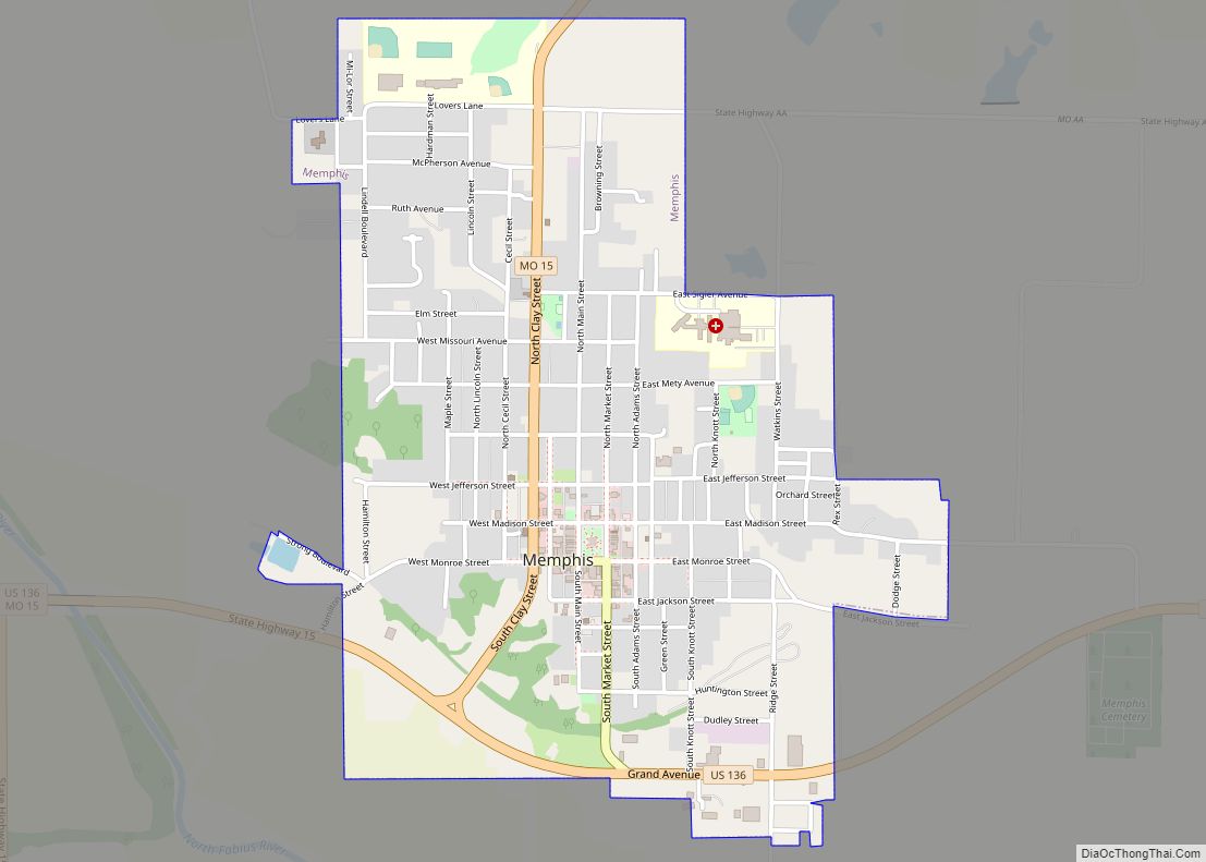
Memphis is a city in and the county seat of Scotland County, on the northern border of Missouri, United States. As of the 2020 census, its population was 1,731. U.S. Highway 136 passes near Memphis, which is east of Lancaster and west of Kahoka. Memphis city overview: Name: Memphis city LSAD Code: 25 LSAD Description: … Read more

Map of Mehlville CDP

Map of Mehlville CDP

Mehlville is a census-designated place (CDP) in south St. Louis County, Missouri, United States, an area locally known as “South County”. It is an inner-ring suburb of St. Louis, and part of the Greater St. Louis metropolitan area. Mehlville CDP overview: Name: Mehlville CDP LSAD Code: 57 LSAD Description: CDP (suffix) State: Missouri County: St. … Read more

Map of Merriam Woods village

Map of Merriam Woods village

Merriam Woods is a city in Taney County, Missouri, United States. The population was 2,006 at the 2020 census. It is part of the Branson, Missouri Micropolitan Statistical Area. Merriam Woods village overview: Name: Merriam Woods village LSAD Code: 47 LSAD Description: village (suffix) State: Missouri County: Taney County Elevation: 869 ft (265 m) Total Area: 1.51 sq mi … Read more

Map of Mercer town

Map of Mercer town, Missouri

Mercer is a city in Mercer County, Missouri, United States. The population was 263 at the 2020 census. Mercer town overview: Name: Mercer town LSAD Code: 43 LSAD Description: town (suffix) State: Missouri County: Mercer County Elevation: 1,083 ft (330 m) Total Area: 0.37 sq mi (0.95 km²) Land Area: 0.37 sq mi (0.95 km²) Water Area: 0.00 sq mi (0.00 km²) Total Population: 263 Population … Read more

Map of Merwin village

Map of Merwin village

Merwin is a village in Bates County, Missouri, and is part of the Kansas City metropolitan area within the United States. The population was 69 at the 2020 census. Merwin village overview: Name: Merwin village LSAD Code: 47 LSAD Description: village (suffix) State: Missouri County: Bates County Elevation: 899 ft (274 m) Total Area: 0.15 sq mi (0.38 km²) Land … Read more

Map of Mexico city, Missouri

Map of Mexico city, Missouri

Mexico, formerly known as New Mexico, is a city in and the county seat of Audrain County, Missouri. It is home to the Missouri Military Academy and annually hosts the Miss Missouri Pageant. The city’s population was 11,469 at the 2020 census. The micropolitan statistical area consists of Audrain County. It is a part of … Read more

Map of Metz town

Map of Metz town

Metz is a village in Vernon County, Missouri, United States. The population was 49 at the 2010 census, at which time it was a town. Metz town overview: Name: Metz town LSAD Code: 43 LSAD Description: town (suffix) State: Missouri County: Vernon County Elevation: 781 ft (238 m) Total Area: 0.13 sq mi (0.33 km²) Land Area: 0.13 sq mi (0.33 km²) Water … Read more

Map of Meta city

Map of Meta city

Meta is a city in Osage County, Missouri, United States. The population was 180 at the 2020 census. It is part of the Jefferson City, Missouri Metropolitan Statistical Area and is also the world headquarters of Diamond Pet Foods. Meta city overview: Name: Meta city LSAD Code: 25 LSAD Description: city (suffix) State: Missouri County: … Read more

Map of Milan city, Missouri

Map of Milan city, Missouri

Milan (/ˈmaɪlən/ MY-lən) is a city in Sullivan County, Missouri, United States. The population was 1,819 at the 2020 census. It is the county seat of Sullivan County. Milan city overview: Name: Milan city LSAD Code: 25 LSAD Description: city (suffix) State: Missouri County: Sullivan County Elevation: 965 ft (294 m) Total Area: 1.78 sq mi (4.62 km²) Land Area: … Read more

Map of Middletown town, Missouri

Map of Middletown town, Missouri

Middletown is a city in Montgomery County, Missouri, United States. The population was 171 at the 2020 census. Middletown town overview: Name: Middletown town LSAD Code: 43 LSAD Description: town (suffix) State: Missouri County: Montgomery County Elevation: 702 ft (214 m) Total Area: 0.32 sq mi (0.83 km²) Land Area: 0.32 sq mi (0.83 km²) Water Area: 0.00 sq mi (0.00 km²) Total Population: 171 Population … Read more

Map of Miami city, Missouri

Map of Miami city, Missouri

Miami is a city in Saline County, Missouri, United States. The population was 175 at the 2010 census. Miami city overview: Name: Miami city LSAD Code: 25 LSAD Description: city (suffix) State: Missouri County: Saline County Elevation: 748 ft (228 m) Total Area: 0.63 sq mi (1.63 km²) Land Area: 0.56 sq mi (1.45 km²) Water Area: 0.07 sq mi (0.19 km²) Total Population: 152 Population … Read more

Map of Millard village

Map of Millard village

Millard is a village in Pettis Township, Adair County, Missouri, United States. The population was 89 at the 2010 census. Millard village overview: Name: Millard village LSAD Code: 47 LSAD Description: village (suffix) State: Missouri County: Adair County Elevation: 968 ft (295 m) Total Area: 0.12 sq mi (0.31 km²) Land Area: 0.12 sq mi (0.31 km²) Water Area: 0.00 sq mi (0.00 km²) Total Population: … Read more