Map of Olympian Village city

Map of Olympian Village city

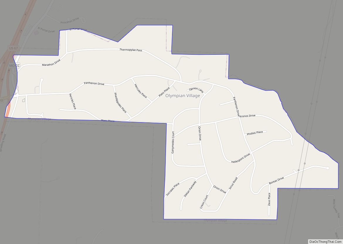
Olympian Village is a city in Jefferson County, Missouri, United States. The population was 774 at the 2010 census. The city was named in honor of Greek myth and culture. Some street names include Parthenon Drive, Kronos Drive, Hercules Place, Plato Place, and Pheidippides Place. Olympian Village city overview: Name: Olympian Village city LSAD Code: … Read more

Map of Olivette city

Map of Olivette city

Olivette is an inner-ring suburb of St. Louis, located in St. Louis County, Missouri, United States. The population was 8,504 at the 2020 census. Olivette city overview: Name: Olivette city LSAD Code: 25 LSAD Description: city (suffix) State: Missouri County: St. Louis County Elevation: 676 ft (206 m) Total Area: 2.77 sq mi (7.18 km²) Land Area: 2.77 sq mi (7.18 km²) Water … Read more

Map of Oronogo city

Map of Oronogo city

Oronogo is a city in Jasper County, Missouri, United States. The population was 2,558 at the 2020 census. It is part of the Joplin, Missouri Metropolitan Statistical Area. Oronogo city overview: Name: Oronogo city LSAD Code: 25 LSAD Description: city (suffix) State: Missouri County: Jasper County Elevation: 955 ft (291 m) Total Area: 2.51 sq mi (6.51 km²) Land Area: … Read more

Map of Oregon city, Missouri

Map of Oregon city, Missouri

Oregon is a city and county seat of Holt County, Missouri, United States. The population was 837 at the 2020 census. Oregon city overview: Name: Oregon city LSAD Code: 25 LSAD Description: city (suffix) State: Missouri County: Holt County Elevation: 1,089 ft (332 m) Total Area: 0.93 sq mi (2.40 km²) Land Area: 0.93 sq mi (2.40 km²) Water Area: 0.00 sq mi (0.00 km²) Total … Read more

Map of Orrick city

Map of Orrick city

Orrick is a town in Ray County, Missouri, and part of the Kansas City metropolitan area within the United States. The population was 753 at the 2020 census. Orrick city overview: Name: Orrick city LSAD Code: 25 LSAD Description: city (suffix) State: Missouri County: Ray County Elevation: 722 ft (220 m) Total Area: 1.33 sq mi (3.46 km²) Land Area: … Read more

Map of Osceola city, Missouri

Map of Osceola city, Missouri

Osceola is a city in St. Clair County, Missouri, United States. The population was 909 at the 2020 census. It is the county seat of St. Clair County. During the American Civil War, Osceola was the site of the Sacking of Osceola. Osceola city overview: Name: Osceola city LSAD Code: 25 LSAD Description: city (suffix) … Read more

Map of Osborn city

Map of Osborn city

Osborn is a city in northern Clinton and southern DeKalb counties in the U.S. state of Missouri. The population was 374 at the 2020 census. The Clinton County portion of Osborn is part of the Kansas City, MO–KS Metropolitan Statistical Area, while the DeKalb County portion is part of the St. Joseph, MO–KS Metropolitan Statistical … Read more

Map of Osage Beach city

Map of Osage Beach city

Osage Beach is a city in Camden and Miller counties in the U.S. state of Missouri. Most of the city is in Camden County, while a small eastern sliver is in Miller County. The population was 4,351 at the 2010 census. Osage Beach city overview: Name: Osage Beach city LSAD Code: 25 LSAD Description: city … Read more

Map of Overland city

Map of Overland city, Missouri

Overland is a city in St. Louis County, Missouri, United States. The population was 16,062 at the 2010 census. Overland city overview: Name: Overland city LSAD Code: 25 LSAD Description: city (suffix) State: Missouri County: St. Louis County Elevation: 650 ft (200 m) Total Area: 4.41 sq mi (11.41 km²) Land Area: 4.39 sq mi (11.37 km²) Water Area: 0.02 sq mi (0.04 km²) Total Population: … Read more

Map of Otterville city, Missouri

Map of Otterville city, Missouri

Otterville is a city in southwest Cooper County, Missouri, United States. The population was 454 at the 2010 census. Otterville city overview: Name: Otterville city LSAD Code: 25 LSAD Description: city (suffix) State: Missouri County: Cooper County Elevation: 810 ft (250 m) Total Area: 0.49 sq mi (1.27 km²) Land Area: 0.49 sq mi (1.27 km²) Water Area: 0.00 sq mi (0.00 km²) Total Population: 440 … Read more

Map of Osgood village, Missouri

Map of Osgood village, Missouri

Osgood is a village in western Sullivan County, Missouri, United States. The population was 24 at the 2020 census. Osgood village overview: Name: Osgood village LSAD Code: 47 LSAD Description: village (suffix) State: Missouri County: Sullivan County Elevation: 817 ft (249 m) Total Area: 0.18 sq mi (0.47 km²) Land Area: 0.18 sq mi (0.47 km²) Water Area: 0.00 sq mi (0.00 km²) Total Population: 24 … Read more

Map of Ozark city, Missouri

Map of Ozark city, Missouri

Ozark is a city in and the county seat of Christian County, Missouri. Its population was 21,284 as of the 2020 census. Ozark is also the third largest city in the Springfield, Missouri Metropolitan Area, and is centered along a business loop of U.S. Route 65, where it intersects with Missouri Route 14. Ozark city … Read more