Map of Vinita Park city

Map of Vinita Park city

Vinita Park is a city in St. Louis County, Missouri, United States, located just east of I-170 and south of St. Charles Rock Road. The population was 1,970 at the 2020 census. Vinita Park city overview: Name: Vinita Park city LSAD Code: 25 LSAD Description: city (suffix) State: Missouri County: St. Louis County Elevation: 594 ft … Read more

Map of Village of Four Seasons village

Map of Village of Four Seasons village

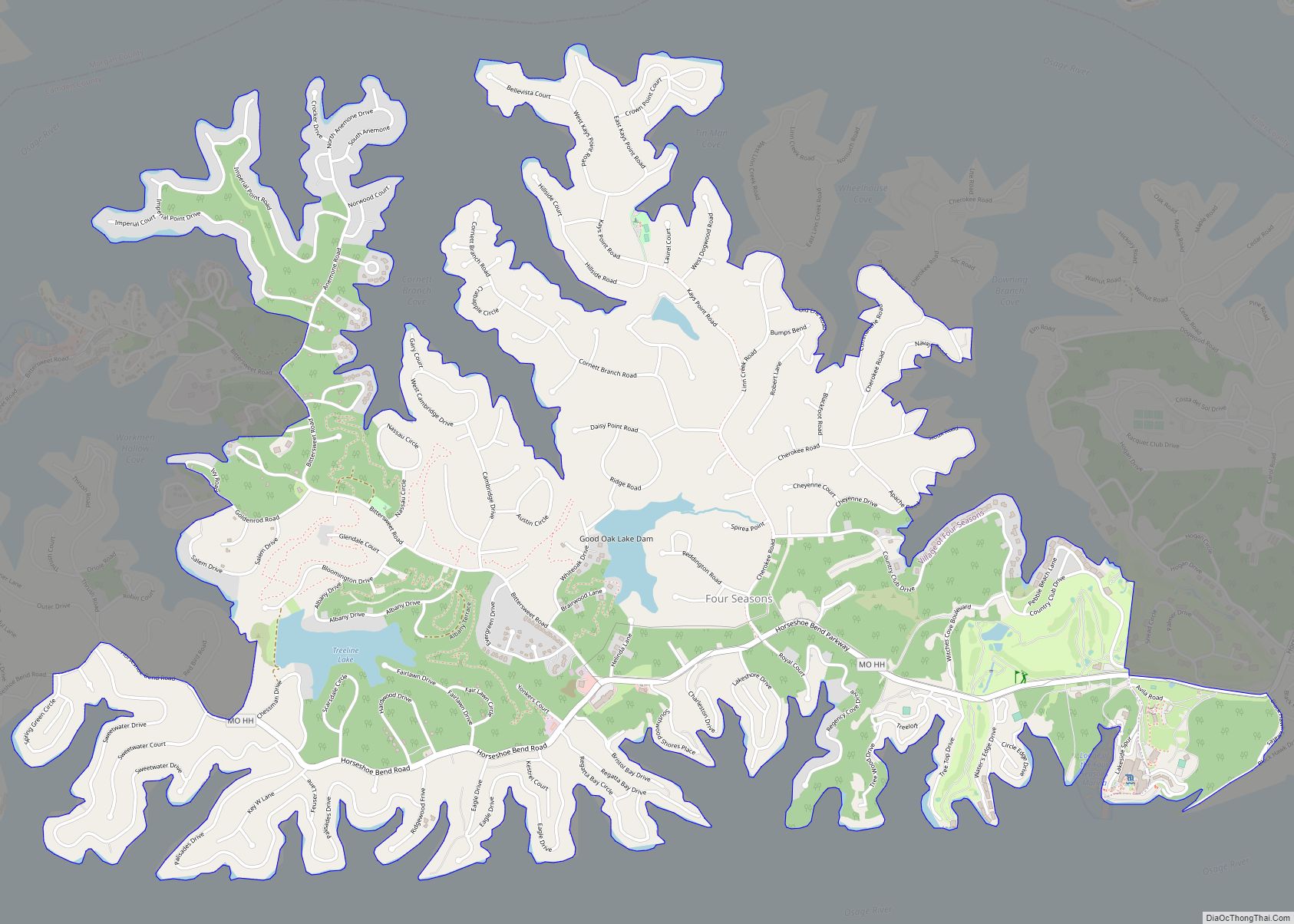
Village of Four Seasons is a village in Camden County, Missouri, United States. The population was 2,217 at the 2010 census. The village is situated on the shores of Lake of the Ozarks and is a popular tourist destination along with the other communities in the area. Village of Four Seasons village overview: Name: Village … Read more

Map of Villa Ridge CDP

Map of Villa Ridge CDP

Villa Ridge is an unincorporated community and census-designated place (CDP) in Franklin County, Missouri, United States. The population was 2,636 at the 2010 census, up from 2,417 at the 2000 census. Villa Ridge CDP overview: Name: Villa Ridge CDP LSAD Code: 57 LSAD Description: CDP (suffix) State: Missouri County: Franklin County Elevation: 663 ft (202 m) Total … Read more

Map of Vienna city, Missouri

Map of Vienna city, Missouri

Vienna is a city in and the county seat of Maries County, Missouri, United States. Its population was 581 at the 2020 census. Vienna city overview: Name: Vienna city LSAD Code: 25 LSAD Description: city (suffix) State: Missouri County: Maries County Incorporated: 1856 Elevation: 843 ft (257 m) Total Area: 1.07 sq mi (2.77 km²) Land Area: 1.07 sq mi (2.77 km²) Water … Read more

Map of Wardell town

Map of Wardell town

Wardell is a city in Pemiscot County, Missouri, United States. The population was 310 at the 2020 census. It annexed North Wardell in 2007. Wardell town overview: Name: Wardell town LSAD Code: 43 LSAD Description: town (suffix) State: Missouri County: Pemiscot County Elevation: 269 ft (82 m) Total Area: 0.28 sq mi (0.74 km²) Land Area: 0.28 sq mi (0.73 km²) Water Area: … Read more

Map of Walnut Grove city, Missouri

Map of Walnut Grove city, Missouri

Walnut Grove is a city in Greene County, Missouri, United States. The population was 652 at the 2020 census. It is part of the Springfield, Missouri Metropolitan Statistical Area. Claudette Riley of the Springfield News-Leader described it as “a largely agricultural community with a relatively low tax base.” Walnut Grove city overview: Name: Walnut Grove … Read more

Map of Walker city, Missouri

Map of Walker city, Missouri

Walker is a city in Vernon County, Missouri, United States. The population was 199 at the 2020 census. Walker city overview: Name: Walker city LSAD Code: 25 LSAD Description: city (suffix) State: Missouri County: Vernon County Elevation: 853 ft (260 m) Total Area: 0.31 sq mi (0.81 km²) Land Area: 0.31 sq mi (0.81 km²) Water Area: 0.00 sq mi (0.00 km²) Total Population: 199 Population … Read more

Map of Waco city, Missouri

Map of Waco city, Missouri

Waco is a city in Jasper County, Missouri, United States. The population was 72 at the 2020 census. It is part of the Joplin, Missouri Metropolitan Statistical Area. Waco city overview: Name: Waco city LSAD Code: 25 LSAD Description: city (suffix) State: Missouri County: Jasper County Elevation: 902 ft (275 m) Total Area: 0.26 sq mi (0.66 km²) Land Area: … Read more

Map of Vista village, Missouri

Map of Vista village, Missouri

Vista is a village in St. Clair County, Missouri, United States. The population was 36 at the 2020 census. Vista village overview: Name: Vista village LSAD Code: 47 LSAD Description: village (suffix) State: Missouri County: St. Clair County Elevation: 853 ft (260 m) Total Area: 0.13 sq mi (0.34 km²) Land Area: 0.13 sq mi (0.34 km²) Water Area: 0.00 sq mi (0.00 km²) Total Population: … Read more

Map of Warson Woods city

Map of Warson Woods city

Warson Woods is a city in St. Louis County, Missouri, United States. The population was 1,962 at the 2010 census. Warson Woods city overview: Name: Warson Woods city LSAD Code: 25 LSAD Description: city (suffix) State: Missouri County: St. Louis County Elevation: 594 ft (181 m) Total Area: 0.57 sq mi (1.47 km²) Land Area: 0.57 sq mi (1.47 km²) Water Area: 0.00 sq mi … Read more

Map of Warsaw city, Missouri

Map of Warsaw city, Missouri

Warsaw is a city located in Benton County, Missouri, United States. The population was 2,127 at the 2010 census. Warsaw is the county seat of Benton County. Adjacent to the Osage River it is heavily tied to two major lakes on the river. The uppermost reaches of Lake of the Ozarks is part of southwest … Read more

Map of Warrenton city, Missouri

Map of Warrenton city, Missouri

Warrenton is a city in Warren County, Missouri, United States. The population was 7,880 according to the 2010 Census. It is the county seat of Warren County. Warrenton is an exurb of St. Louis, and is located in the St. Louis Metropolitan Statistical Area. Warrenton’s slogan is “A City for All Seasons.” Warrenton city overview: … Read more