Map of Warrensburg city, Missouri

Map of Warrensburg city, Missouri

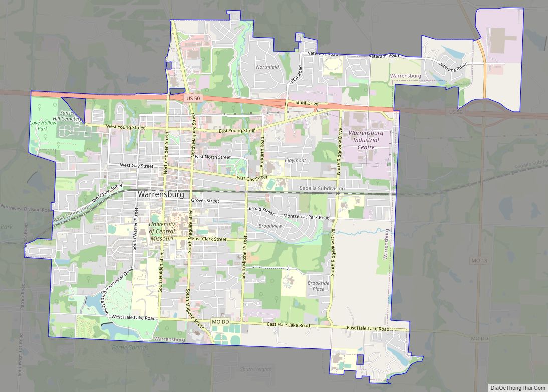
Warrensburg is a city in and the county seat of Johnson County, Missouri, United States. The population was 20,313 at the 2020 census. The Warrensburg Micropolitan Statistical Area consists of Johnson County. The city is a college town as it is home to the University of Central Missouri. Warrensburg city overview: Name: Warrensburg city LSAD … Read more

Map of Wardsville village

Map of Wardsville village

Wardsville is a village in Cole County, Missouri, United States. The population was 1,599 at the 2020 census. It is part of the Jefferson City, Missouri Metropolitan Statistical Area. Wardsville village overview: Name: Wardsville village LSAD Code: 47 LSAD Description: village (suffix) State: Missouri County: Cole County Incorporated: 1881 Elevation: 732 ft (223 m) Total Area: 3.47 sq mi … Read more

Map of Waverly city, Missouri

Map of Waverly city, Missouri

Waverly is a city in Lafayette County, Missouri, and part of the Kansas City metropolitan area within the United States. The population was 849 at the 2010 census. Waverly is the location of Baltimore Bend Winery, one of the many small wineries established in the state since the 1960s. The Waverly Bridge over the Missouri … Read more

Map of Watson village, Missouri

Map of Watson village, Missouri

Watson is a village in Nishnabotna Township, Atchison County, Missouri, United States. The population was 61 at the 2020 census. It is the westernmost settlement in the state of Missouri, about 120 miles northwest of Kansas City. Watson village overview: Name: Watson village LSAD Code: 47 LSAD Description: village (suffix) State: Missouri County: Atchison County … Read more

Map of Wasola CDP

Map of Wasola CDP

Wasola is an unincorporated community in northern Ozark County, Missouri, United States. It is located sixteen miles north of Gainesville on Route 5, at its northern intersection with Route 95. The Ozark–Douglas county line is approximately one–half mile north of the town. A few businesses and homes are located there. The community was founded in … Read more

Map of Washington city, Missouri

Map of Washington city, Missouri

Washington is a city on the south banks of the Missouri River, 50 miles west of St. Louis, Missouri, and the largest in Franklin County, Missouri, United States. The estimated population in July 2021 was 14,916, an increase of 7% since the 2010 census. It is the corncob pipe capital of the world, with Missouri … Read more

Map of Washburn city, Missouri

Map of Washburn city, Missouri

Washburn is a city in Washburn Township, Barry County, Missouri, United States. The current town encompasses the sites of two communities formerly known as Keetsville and O’Day and is named for local pioneer Samuel C. Washburn. The population was 435 at the 2010 census. Washburn city overview: Name: Washburn city LSAD Code: 25 LSAD Description: … Read more

Map of Weaubleau city

Map of Weaubleau city

Weaubleau is a city in Hickory County, Missouri, United States, founded in 1867. The population was 378 at the 2020 census. Weaubleau city overview: Name: Weaubleau city LSAD Code: 25 LSAD Description: city (suffix) State: Missouri County: Hickory County Elevation: 988 ft (301 m) Total Area: 0.87 sq mi (2.26 km²) Land Area: 0.86 sq mi (2.24 km²) Water Area: 0.01 sq mi (0.02 km²) Total … Read more

Map of Weatherby town

Map of Weatherby town

Weatherby is a village in eastern DeKalb County, Missouri, United States. The population was 80 at the 2020 census. It is part of the St. Joseph, MO–KS Metropolitan Statistical Area. Weatherby town overview: Name: Weatherby town LSAD Code: 43 LSAD Description: town (suffix) State: Missouri County: DeKalb County Elevation: 879 ft (268 m) Total Area: 0.12 sq mi (0.31 km²) … Read more

Map of Weatherby Lake city

Map of Weatherby Lake city

Weatherby Lake is a city in Platte County, Missouri and is part of the Kansas City metropolitan area within the United States, which borders Kansas City. The population was 1,723 as of the 2010 census. Weatherby Lake city overview: Name: Weatherby Lake city LSAD Code: 25 LSAD Description: city (suffix) State: Missouri County: Platte County … Read more

Map of Waynesville city, Missouri

Map of Waynesville city, Missouri

Waynesville is a city in and the county seat of Pulaski County, Missouri, United States. Its population was 5,406 at the 2020 census. Located in the heart of the Missouri Ozarks, it was one of the communities served by historic Route 66. Waynesville city overview: Name: Waynesville city LSAD Code: 25 LSAD Description: city (suffix) … Read more

Map of Wayland city, Missouri

Map of Wayland city, Missouri

Wayland is a city in Clark County, Missouri, United States. As of the 2020 census, its population was 408. It is part of the Fort Madison–Keokuk, IA-MO Micropolitan Statistical Area. Wayland city overview: Name: Wayland city LSAD Code: 25 LSAD Description: city (suffix) State: Missouri County: Clark County Elevation: 535 ft (163 m) Total Area: 0.67 sq mi (1.74 km²) … Read more