Map of Hamilton city, Montana
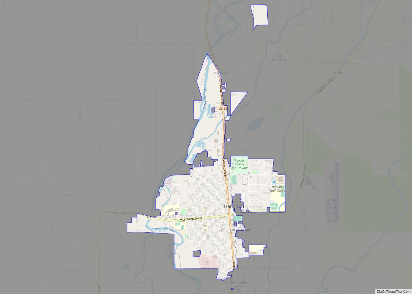
Hamilton is a city that serves as the county seat of Ravalli County, Montana, United States. The population was 4,659 at the 2020 census. Hamilton city overview: Name: Hamilton city LSAD Code: 25 LSAD Description: city (suffix) State: Montana County: Ravalli County Elevation: 3,570 ft (1,090 m) Total Area: 2.60 sq mi (6.73 km²) Land Area: 2.54 sq mi (6.58 km²) Water Area: ... Read more
Map of Hamilton city, Montana
Map of Hays CDP, Montana
Hays is a census-designated place (CDP) in Blaine County, Montana, United States. The population was 843 at the 2010 census. The community lies within the Fort Belknap Indian Reservation, near the reservation’s southern end. The nearby community of Lodge Pole lies to the east. The town was named for Major Hays. The Bureau of Catholic ... Read more
Map of Hays CDP, Montana
Map of Havre city
Havre (/ˈhævər/ HAV-ər) is the county seat and largest city in Hill County, Montana, United States. Havre is nicknamed the crown jewel of the Hi-Line. It is said to be named after the city of Le Havre in France. As of the 2020 census the population was 9,362. Havre city overview: Name: Havre city LSAD ... Read more
Map of Havre city
Map of Havre North CDP
Havre North is a census-designated place (CDP) in Hill County, Montana, United States. The population was 716 at the 2010 census, down from 973 in 2000. Havre North CDP overview: Name: Havre North CDP LSAD Code: 57 LSAD Description: CDP (suffix) State: Montana County: Hill County Elevation: 2,475 ft (754 m) Total Area: 3.35 sq mi (8.68 km²) Land Area: ... Read more
Map of Havre North CDP
Map of Harrison CDP, Montana
Harrison is a census-designated place (CDP) in Madison County, Montana, United States. The population was 137 at the 2010 census, down from 162 in 2000. The town began as Ferguson, a stage stop on the road to Virginia City. The Northern Pacific Railroad constructed a branch line in 1889. Eventually the town was called Harrison ... Read more
Map of Harrison CDP, Montana
Map of Harlowton city
Harlowton is a city in and the county seat of Wheatland County, Montana, United States. The population was 955 at the 2020 census. Harlowton city overview: Name: Harlowton city LSAD Code: 25 LSAD Description: city (suffix) State: Montana County: Wheatland County Elevation: 4,196 ft (1,279 m) Total Area: 0.63 sq mi (1.62 km²) Land Area: 0.63 sq mi (1.62 km²) Water Area: 0.00 sq mi ... Read more
Map of Harlowton city
Map of Helena Valley Northwest CDP
Helena Valley Northwest is a census-designated place (CDP) in Lewis and Clark County, Montana, United States. The population was 3,482 at the 2010 census. It is part of the Helena Micropolitan Statistical Area. Helena Valley Northwest CDP overview: Name: Helena Valley Northwest CDP LSAD Code: 57 LSAD Description: CDP (suffix) State: Montana County: Lewis and ... Read more
Map of Helena Valley Northwest CDP
Map of Helena Valley Northeast CDP
Helena Valley Northeast is a census-designated place (CDP) in Lewis and Clark County, Montana, United States. The population was 2,995 at the 2010 census. It is part of the Helena Micropolitan Statistical Area. Helena Valley Northeast CDP overview: Name: Helena Valley Northeast CDP LSAD Code: 57 LSAD Description: CDP (suffix) State: Montana County: Lewis and ... Read more
Map of Helena Valley Northeast CDP
Map of Helena Flats CDP
Helena Flats is a census-designated place (CDP) in Flathead County, Montana, United States. The population was 1,043 in the 2010 census. Helena Flats CDP overview: Name: Helena Flats CDP LSAD Code: 57 LSAD Description: CDP (suffix) State: Montana County: Flathead County Elevation: 2,956 ft (901 m) Total Area: 8.71 sq mi (22.56 km²) Land Area: 8.44 sq mi (21.86 km²) Water Area: 0.27 sq mi ... Read more
Map of Helena Flats CDP
Map of Hebgen Lake Estates CDP
Hebgen Lake Estates is a census-designated place (CDP) in Gallatin County, Montana, United States. The population was 70 at the 2010 census. It is next to Hebgen Lake. Hebgen Lake Estates CDP overview: Name: Hebgen Lake Estates CDP LSAD Code: 57 LSAD Description: CDP (suffix) State: Montana County: Gallatin County Elevation: 6,562 ft (2,000 m) Total Area: ... Read more
Map of Hebgen Lake Estates CDP
Map of Heart Butte CDP
Heart Butte (Blackfeet: Moskizipahpi-istaki) is a census-designated place (CDP) in Pondera County, Montana, United States. The population was 698 at the 2000 census. The town is on the Blackfeet Indian Reservation. The town takes its name from the small heart-shaped peak southwest of town. Heart Butte CDP overview: Name: Heart Butte CDP LSAD Code: 57 ... Read more
Map of Heart Butte CDP
Map of Helena Valley West Central CDP
Helena Valley West Central is a census-designated place (CDP) in Lewis and Clark County, Montana, United States. The population was 7,883 at the 2010 census. It is part of the Helena Micropolitan Statistical Area. Helena Valley West Central CDP overview: Name: Helena Valley West Central CDP LSAD Code: 57 LSAD Description: CDP (suffix) State: Montana ... Read more
Map of Helena Valley West Central CDP