Map of Bradshaw village

Map of Bradshaw village, Nebraska

Bradshaw is a village in York County, Nebraska, United States. The population was 273 at the 2010 census. Bradshaw village overview: Name: Bradshaw village LSAD Code: 47 LSAD Description: village (suffix) State: Nebraska County: York County Elevation: 1,719 ft (524 m) Total Area: 0.31 sq mi (0.81 km²) Land Area: 0.31 sq mi (0.81 km²) Water Area: 0.00 sq mi (0.00 km²) Total Population: 273 Population … Read more

Map of Boys Town village

Map of Boys Town village

Boys Town is a village in Douglas County, Nebraska, United States. The population was 410 at the 2020 census. Boys Town is an enclave and a suburb of Omaha. The village of Boys Town was established in 1917 as the headquarters of Father Flanagan’s Boys’ Home (Boys Town), founded by Father Edward J. Flanagan. The … Read more

Map of Broken Bow city

Map of Broken Bow city, Nebraska

Broken Bow is a city in Custer County, Nebraska, United States. The population was 3,559 at the 1975 census. It is the county seat of Custer County. Broken Bow city overview: Name: Broken Bow city LSAD Code: 25 LSAD Description: city (suffix) State: Nebraska County: Custer County Elevation: 2,477 ft (755 m) Total Area: 2.02 sq mi (5.23 km²) Land … Read more

Map of Brock village

Map of Brock village

Brock is a village in Nemaha County, Nebraska, United States. The population was 122 at the 2020 census. Brock village overview: Name: Brock village LSAD Code: 47 LSAD Description: village (suffix) State: Nebraska County: Nemaha County Elevation: 965 ft (294 m) Total Area: 0.31 sq mi (0.81 km²) Land Area: 0.31 sq mi (0.81 km²) Water Area: 0.00 sq mi (0.00 km²) Total Population: 122 Population … Read more

Map of Broadwater village

Map of Broadwater village

Broadwater is a village in Morrill County, Nebraska, United States. The population was 128 at the 2010 census. Broadwater village overview: Name: Broadwater village LSAD Code: 47 LSAD Description: village (suffix) State: Nebraska County: Morrill County Elevation: 3,586 ft (1,093 m) Total Area: 0.16 sq mi (0.41 km²) Land Area: 0.16 sq mi (0.41 km²) Water Area: 0.00 sq mi (0.00 km²) Total Population: 95 Population … Read more

Map of Bristow village, Nebraska

Map of Bristow village, Nebraska

Bristow is a village in Boyd County, Nebraska, United States. The population was 65 at the 2010 census, down from 88 in 2000. Bristow village overview: Name: Bristow village LSAD Code: 47 LSAD Description: village (suffix) State: Nebraska County: Boyd County Elevation: 1,473 ft (449 m) Total Area: 0.16 sq mi (0.42 km²) Land Area: 0.16 sq mi (0.42 km²) Water Area: 0.00 sq mi … Read more

Map of Bridgeport city, Nebraska

Map of Bridgeport city, Nebraska

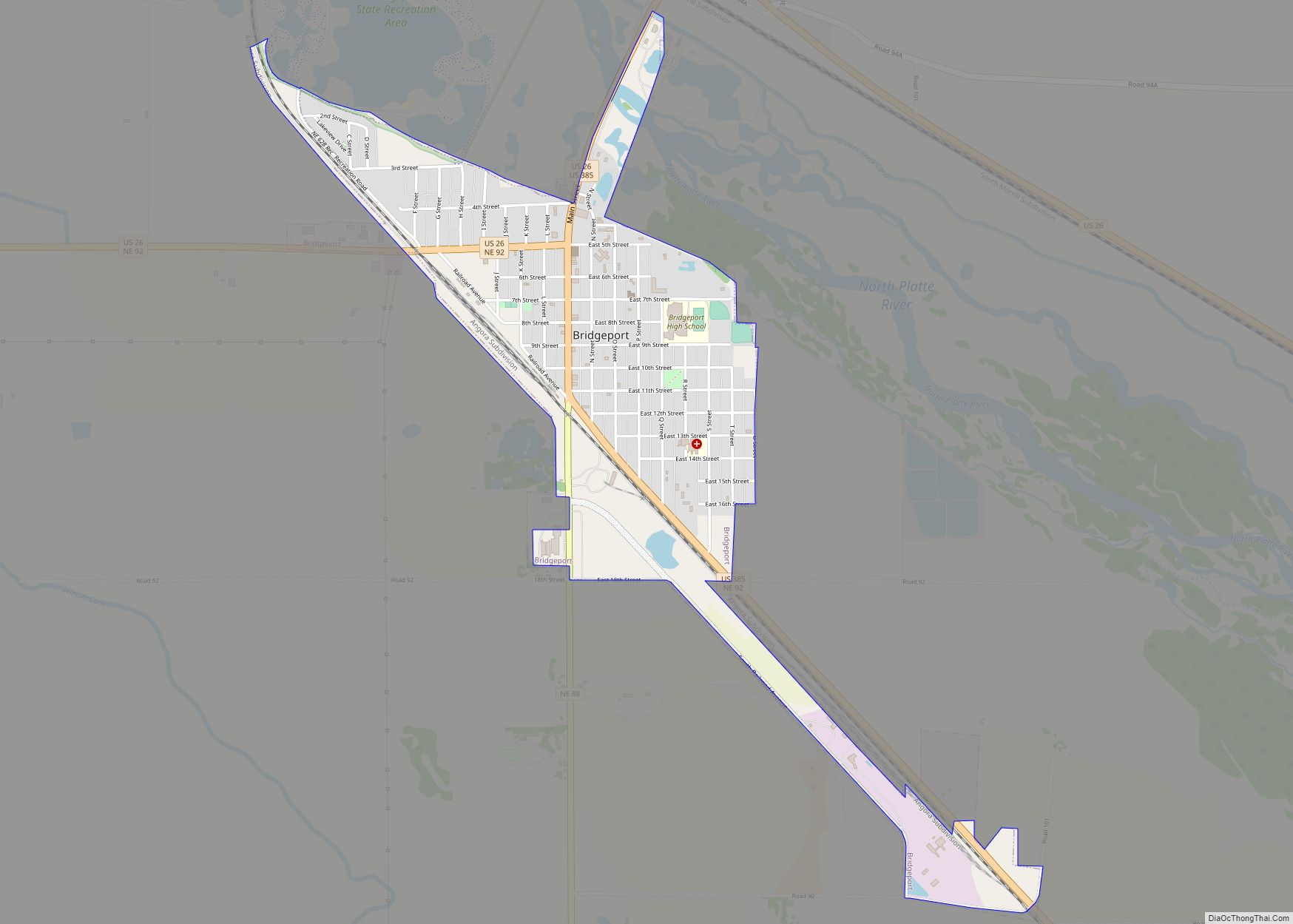
Bridgeport is a city in Morrill County, Nebraska, United States. The population was 1,454 at the 2020 census. It is the county seat of Morrill County. Bridgeport city overview: Name: Bridgeport city LSAD Code: 25 LSAD Description: city (suffix) State: Nebraska County: Morrill County Elevation: 3,665 ft (1,117 m) Total Area: 1.20 sq mi (3.11 km²) Land Area: 1.20 sq mi (3.10 km²) … Read more

Map of Brewster village, Nebraska

Map of Brewster village, Nebraska

Brewster is a village in, and the county seat of, Blaine County, Nebraska, United States. The population was 17 at the 2010 census. Brewster village overview: Name: Brewster village LSAD Code: 47 LSAD Description: village (suffix) State: Nebraska County: Blaine County Elevation: 2,493 ft (760 m) Total Area: 0.09 sq mi (0.23 km²) Land Area: 0.09 sq mi (0.23 km²) Water Area: 0.00 sq mi … Read more

Map of Burwell city

Map of Burwell city

Burwell is a city in Garfield County, Nebraska, United States. The population was 1,210 at the 2010 census. It is the county seat of Garfield County. Burwell city overview: Name: Burwell city LSAD Code: 25 LSAD Description: city (suffix) State: Nebraska County: Garfield County Elevation: 2,175 ft (663 m) Total Area: 1.05 sq mi (2.72 km²) Land Area: 1.05 sq mi (2.72 km²) … Read more

Map of Burton village, Nebraska

Map of Burton village, Nebraska

Burton is a tiny village in Keya Paha County, Nebraska, United States. There are two churches there, and two or three houses. The population was 11 at the 2020 census. Burton village overview: Name: Burton village LSAD Code: 47 LSAD Description: village (suffix) State: Nebraska County: Keya Paha County Elevation: 2,142 ft (653 m) Total Area: 0.10 sq mi … Read more

Map of Burr village

Map of Burr village

Burr is a village in Otoe County, Nebraska, United States. The population was 52 at the 2020 census. Burr village overview: Name: Burr village LSAD Code: 47 LSAD Description: village (suffix) State: Nebraska County: Otoe County Elevation: 1,132 ft (345 m) Total Area: 0.09 sq mi (0.22 km²) Land Area: 0.09 sq mi (0.22 km²) Water Area: 0.00 sq mi (0.00 km²) Total Population: 52 Population … Read more

Map of Burchard village

Map of Burchard village

Burchard is a village in Pawnee County, Nebraska, United States. The population was 78 at the 2020 census. The village is approximately 10 miles from the Nebraska–Kansas border and ten miles west of Pawnee City. Burchard village overview: Name: Burchard village LSAD Code: 47 LSAD Description: village (suffix) State: Nebraska County: Pawnee County Elevation: 1,411 ft … Read more