Map of Fort Dix CDP

Map of Fort Dix CDP

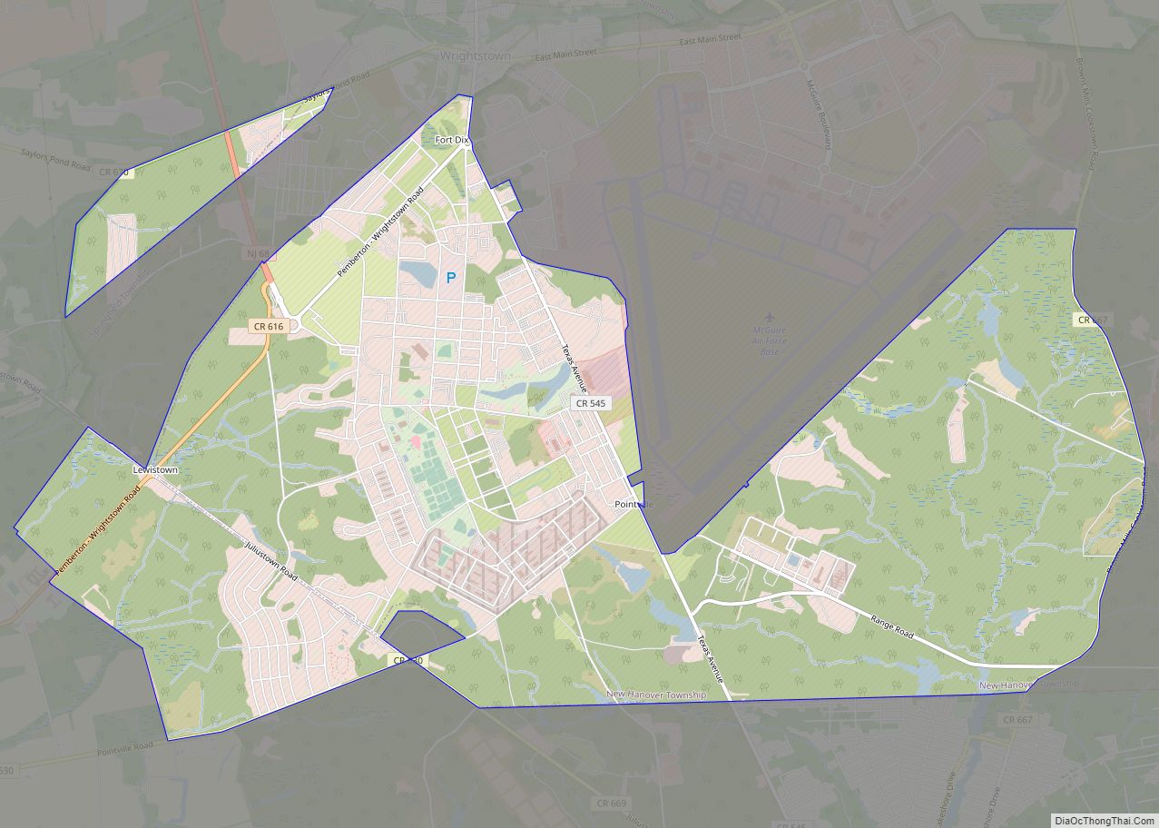
Fort Dix, the common name for the Army Support Activity (ASA) located at Joint Base McGuire–Dix–Lakehurst, is a United States Army post. It is located 16.1 miles (25.9 km) south-southeast of Trenton, New Jersey. Fort Dix is under the jurisdiction of the Air Force Air Mobility Command. As of the 2020 U.S. census, Fort Dix census-designated … Read more

Map of Forked River CDP

Map of Forked River CDP

Forked River (/ˈfɔːrkɪd/) is an unincorporated community and census-designated place (CDP) located within Lacey Township, in Ocean County, in the U.S. state of New Jersey. As of the 2020 United States census, the CDP’s population was 5,274, an increase of 30 (+0.6%) from the 5,244 enumerated at the 2010 census, which in turn reflected an … Read more

Map of Fords CDP

Map of Fords CDP

Fords is an unincorporated community and census-designated place (CDP) located within Woodbridge Township, in Middlesex County, New Jersey, United States. As of the 2010 United States Census, the CDP’s population was 15,187. Fords CDP overview: Name: Fords CDP LSAD Code: 57 LSAD Description: CDP (suffix) State: New Jersey County: Middlesex County Elevation: 138 ft (42 m) Total … Read more

Map of Folsom borough, New Jersey

Map of Folsom borough, New Jersey

Folsom is a borough in Atlantic County, in the U.S. state of New Jersey. Geographically, the city, and all of Atlantic County, is part of the South Jersey region and of the Atlantic City–Hammonton metropolitan statistical area, which in turn is included in the Philadelphia–Reading–Camden combined statistical area and the Delaware Valley. As of the … Read more

Map of Florham Park borough

Map of Florham Park borough

Florham Park is a borough in Morris County, in the U.S. state of New Jersey. As of the 2020 United States census, the borough’s population was 12,585, an increase of 889 (+7.6%) from the 2010 census count of 11,696, which in turn reflected an increase of 2,839 (+32.1%) from the 8,857 counted in the 2000 … Read more

Map of Florence CDP, New Jersey

Map of Florence CDP, New Jersey

Florence is an unincorporated community and census-designated place (CDP) located within Florence Township, in Burlington County, New Jersey, United States, that was established as part of the 2010 United States Census. As of the 2000 United States Census, the CDP was combined as Florence-Roebling, which had a total population of 8,200. As of the 2010 … Read more

Map of Flemington borough, New Jersey

Map of Flemington borough, New Jersey

Flemington is a borough in and the county seat of Hunterdon County, in the U.S. state of New Jersey. Most of the borough is located in the Amwell Valley, a low-lying area of the Newark Basin, and the Raritan Valley, the South Branch of the Raritan River, which flows through the center of Flemington. Northwestern … Read more

Map of Finesville CDP

Map of Finesville CDP

Finesville is an unincorporated community and census-designated place (CDP) located within Pohatcong Township in Warren County, New Jersey, United States, that was defined as part of the 2010 United States Census. As of the 2010 Census, the CDP’s population was 175. Finesville CDP overview: Name: Finesville CDP LSAD Code: 57 LSAD Description: CDP (suffix) State: … Read more

Map of Finderne CDP

Map of Finderne CDP

Finderne is an unincorporated community and census-designated place (CDP) located within Bridgewater Township, in Somerset County, New Jersey, United States. As of the 2010 United States Census, the CDP’s population was 5,600. Located in southeastern Bridgewater between Bound Brook and Somerville, Finderne is a diverse area with older neighborhoods bordering Foothill Road, newer developments, multi-unit … Read more

Map of Fieldsboro borough

Map of Fieldsboro borough

Fieldsboro is a borough in Burlington County, in the U.S. state of New Jersey. As of the 2020 United States census, the borough’s population was 526, a decrease of 14 (−2.6%) from the 2010 census count of 540, which in turn reflected an increase of 18 (+3.4%) from the 522 counted in the 2000 census. … Read more

Map of Franklin Center CDP

Map of Franklin Center CDP

Franklin Center is an unincorporated community and census-designated place (CDP) located in Franklin Township, in Somerset County, New Jersey, United States. As of the 2010 United States Census, the CDP’s population was 4,460. Franklin Center CDP overview: Name: Franklin Center CDP LSAD Code: 57 LSAD Description: CDP (suffix) State: New Jersey County: Somerset County Elevation: … Read more

Map of Fort Lee borough

Map of Fort Lee borough, New Jersey

Fort Lee is a borough at the eastern border of Bergen County, in the U.S. state of New Jersey, situated along the Hudson River atop The Palisades. As of the 2020 United States census, the borough’s population was 40,191, an increase of 4,846 (+13.7%) from the 2010 census count of 35,345, which in turn reflected … Read more