Map of Garfield city, New Jersey
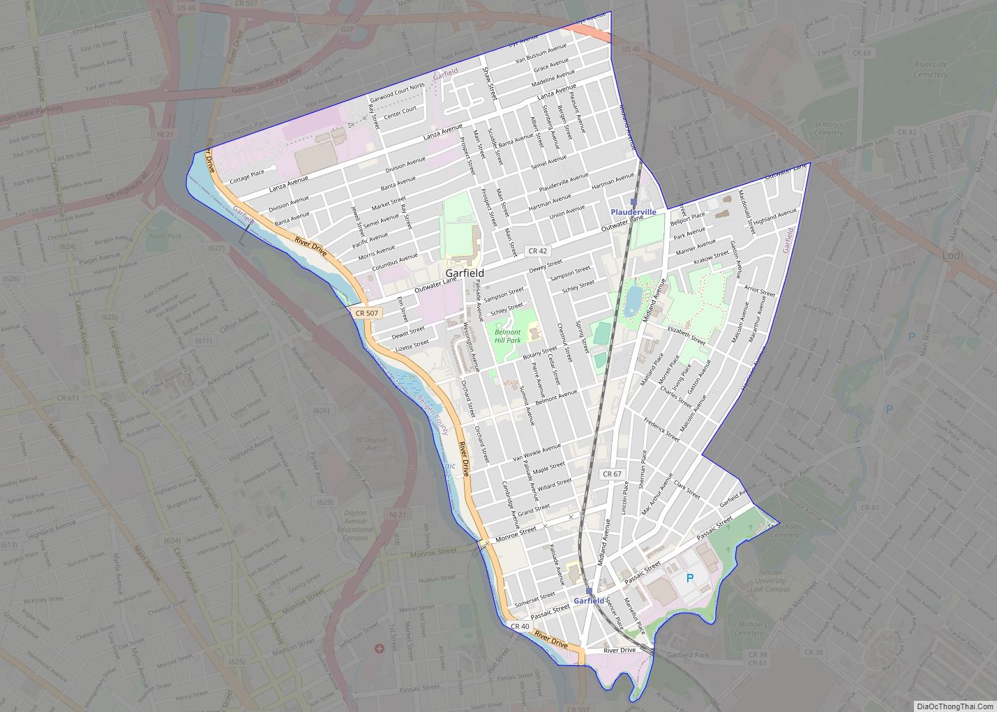
Garfield is a city in Bergen County in the U.S. state of New Jersey. As of the 2020 United States census, the city’s population was 32,655, an increase of 2,168 (+7.1%) from the 2010 census count of 30,487, which in turn reflected an increase of 701 (+2.4%) from the 29,786 counted in the 2000 census. ... Read more
Map of Garfield city, New Jersey
Map of Frenchtown borough, New Jersey
Frenchtown is a borough in Hunterdon County, in the U.S. state of New Jersey. Frenchtown is located along the banks of the Delaware River on the Hunterdon Plateau, 32 miles (51 km) northwest of the state capital of Trenton. As of the 2020 United States census, the borough’s population was 1,370, a decrease of three people ... Read more
Map of Frenchtown borough, New Jersey
Map of Freehold borough
Freehold borough overview: Name: Freehold borough LSAD Code: 21 LSAD Description: borough (suffix) State: New Jersey County: Monmouth County FIPS code: 3425200 Online Interactive Map Freehold online map. Source: Basemap layers from Google Map, Open Street Map (OSM), Arcgisonline, Wmflabs. Boundary Data from Database of Global Administrative Areas. Freehold location map. Where is Freehold borough? ... Read more
Map of Freehold borough
Map of Franklin borough, New Jersey
Franklin borough overview: Name: Franklin borough LSAD Code: 21 LSAD Description: borough (suffix) State: New Jersey County: Sussex County FIPS code: 3424930 Online Interactive Map Franklin online map. Source: Basemap layers from Google Map, Open Street Map (OSM), Arcgisonline, Wmflabs. Boundary Data from Database of Global Administrative Areas. Franklin location map. Where is Franklin borough? ... Read more
Map of Franklin borough, New Jersey
Map of Franklin Park CDP, New Jersey
Franklin Park is an unincorporated community and census-designated place (CDP) located within Franklin Township, in Somerset County, New Jersey, United States. As of the 2010 United States Census, the CDP’s population was 13,295. Route 27 (historically known as Old Road/King’s Highway and once part of the Lincoln Highway system) bisects the village and serves as ... Read more
Map of Franklin Park CDP, New Jersey
Map of Franklin Lakes borough
Franklin Lakes is a borough in Bergen County, in the U.S. state of New Jersey. As of the 2020 United States census, the borough’s population was 11,079, an increase of 489 (+4.6%) from the 2010 census count of 10,590, which in turn reflected an increase of 168 (+1.6%) from the 10,422 counted in the 2000 ... Read more
Map of Franklin Lakes borough
Map of Franklin Center CDP
Franklin Center is an unincorporated community and census-designated place (CDP) located in Franklin Township, in Somerset County, New Jersey, United States. As of the 2010 United States Census, the CDP’s population was 4,460. Franklin Center CDP overview: Name: Franklin Center CDP LSAD Code: 57 LSAD Description: CDP (suffix) State: New Jersey County: Somerset County Elevation: ... Read more
Map of Franklin Center CDP
Map of Fort Lee borough, New Jersey
Fort Lee is a borough at the eastern border of Bergen County, in the U.S. state of New Jersey, situated along the Hudson River atop The Palisades. As of the 2020 United States census, the borough’s population was 40,191, an increase of 4,846 (+13.7%) from the 2010 census count of 35,345, which in turn reflected ... Read more
Map of Fort Lee borough, New Jersey
Map of Glen Ridge borough, New Jersey
Glen Ridge is a borough in Essex County, in the U.S. state of New Jersey. As of the 2020 United States census, the borough’s population was 7,802, an increase of 275 (+3.7%) from the 2010 census count of 7,527, which in turn reflected an increase of 256 (+3.5%) from the 7,271 counted in the 2000 ... Read more
Map of Glen Ridge borough, New Jersey
Map of Glen Gardner borough
Glen Gardner is a borough in Hunterdon County, in the U.S. state of New Jersey. As of the 2020 United States census, the borough’s population was 1,682, a decrease of 22 (−1.3%) from the 2010 census count of 1,704, which in turn reflected a decline of 198 (−10.4%) from the 1,902 counted in the 2000 ... Read more
Map of Glen Gardner borough
Map of Glassboro borough
Glassboro is a borough in Gloucester County, in the U.S. state of New Jersey. As of the 2020 United States census, the borough’s population was 23,149, an increase of 4,570 (+24.6%) from the 2010 census count of 18,579, which in turn reflected a decline of 489 (−2.6%) from the 19,068 counted in the 2000 census. ... Read more
Map of Glassboro borough
Map of Gibbstown CDP
Gibbstown is an unincorporated community and census-designated place (CDP) located within Greenwich Township, in Gloucester County, New Jersey. As of the 2010 U.S. census, the CDP’s population was 3,739. Gibbstown is the location of C. A. Nothnagle Log House, purportedly the oldest house in New Jersey and the oldest surviving log house in the U.S., ... Read more
Map of Gibbstown CDP