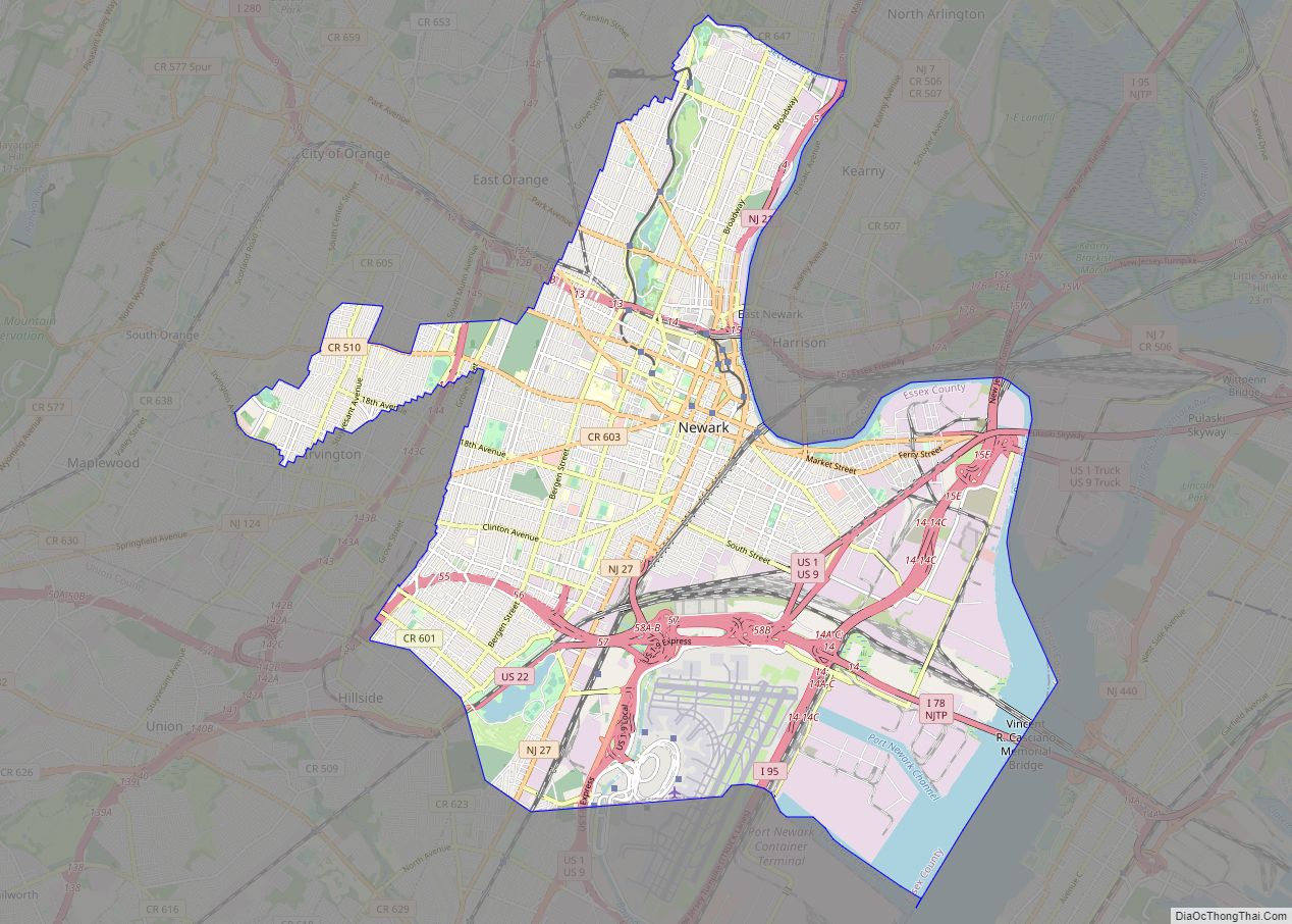
Map of Jersey City city

Map of Jersey City

Jersey City is the second-most populous city in the U.S. state of New Jersey, after Newark. It is the largest city and county seat of Hudson County As of the 2020 United States census, the city’s population was 292,449, an increase of 44,852 (+18.1%) from the 2010 census count of 247,597, in turn an increase … Read more

Map of Paterson city

Map of Paterson city

Paterson city overview: Name: Paterson city LSAD Code: 25 LSAD Description: city (suffix) State: New Jersey County: Passaic County Incorporated: April 11, 1831 (as township) Elevation: 112 ft (34.1376 m) Total Area: 8.71 sq mi (22.55 km²) Land Area: 8.41 sq mi (21.79 km²) Water Area: 0.29 sq mi (0.76 km²)  3.38% Total Population: 159,732 Population Density: 18,986.3/sq mi (7,330.7/km²) Area code: 201 and 973 FIPS code: … Read more

Map of Cape May city

Map of Cape May city

Cape May (sometimes Cape May City) is a city located at the southern tip of Cape May Peninsula in Cape May County in the U.S. state of New Jersey. Located where the Delaware Bay meets the Atlantic Ocean, it is one of the country’s oldest vacation resort destinations. The city, and all of Cape May … Read more

Map of Atlantic City city

Map of Atlantic City, New Jersey

Atlantic City overview: Name: Atlantic City LSAD Code: 25 LSAD Description: city (suffix) State: New Jersey County: Atlantic County Incorporated: May 1, 1854 Elevation: 7 ft (2 m) Land Area: 10.76 sq mi (27.87 km²) Water Area: 6.45 sq mi (16.72 km²)  37.50% Population Density: 3,577.8/sq mi (1,381.4/km²) Area code: 609 FIPS code: 3402080 GNISfeature ID: 0885142 Website: www.cityofatlanticcity.org Online Interactive Map Atlantic City … Read more

Map of Alpine borough, New Jersey

Map of Alpine borough, New Jersey

Alpine is a borough in Bergen County, New Jersey, United States, approximately 15 miles (24 km) north of Midtown Manhattan. It is the easternmost community in New Jersey. As of the 2020 United States census, the borough’s population was 1,762, a decrease of 87 (−4.7%) from the 2010 census count of 1,849, which in turn reflected … Read more

Map of Alpha borough, New Jersey

Map of Alpha borough, New Jersey

Alpha is a borough in Warren County, in the U.S. state of New Jersey. As of the 2020 United States census, the borough’s population was 2,328, a decrease of 41 (−1.7%) from the 2010 census count of 2,369, which in turn reflected a decline of 113 (−4.6%) from the 2,482 counted at the 2000 census. … Read more

Map of Alloway CDP

Map of Alloway CDP

Alloway is an unincorporated community and census-designated place (CDP) located within Alloway Township, in Salem County, in the U.S. state of New Jersey. As of the 2010 United States Census, the CDP’s population was 1,402. Alloway CDP and Alloway Township are not coextensive, with the CDP covering 21.0% of the 24.588 miles (39.571 km) of the … Read more

Map of Allenwood CDP

Map of Allenwood CDP, New Jersey

Allenwood is an unincorporated community and census-designated place (CDP) located within Wall Township, in Monmouth County, in the U.S. state of New Jersey. As of the 2010 United States Census, the CDP’s population was 925. Allenwood CDP overview: Name: Allenwood CDP LSAD Code: 57 LSAD Description: CDP (suffix) State: New Jersey County: Monmouth County Elevation: … Read more

Map of Allentown borough, New Jersey

Map of Allentown borough, New Jersey

Allentown is a borough, located in western Monmouth County, in the U.S. state of New Jersey, bordering nearby Mercer County. As of the 2020 United States census, the borough’s population was 1,734, a decrease of 94 (−5.1%) from the 2010 census count of 1,828, which in turn reflected a decline of 54 (−2.9%) from the … Read more