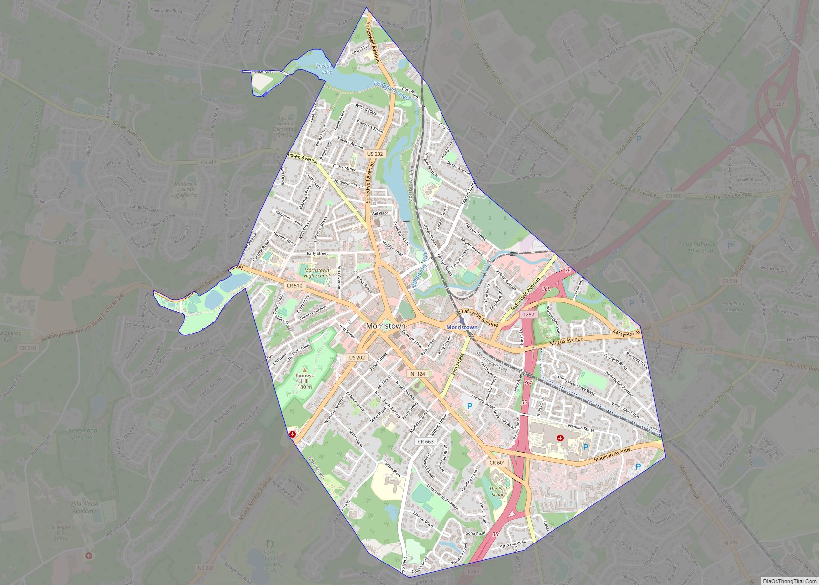
Morris Plains is a borough in Morris County, in the U.S. state of New Jersey. As of the 2020 United States census, the borough’s population was 6,153, an increase of 621 (+11.2%) from the 2010 census count of 5,532, which in turn reflected an increase of 296 (+5.7%) from the 5,236 counted in the 2000 ... Read more
New Jersey Cities and Places
Morganville is an unincorporated community and census-designated place (CDP) within Marlboro Township, in Monmouth County, New Jersey. As of the 2010 United States Census, the CDP’s population was 5,040. Morganville has its own post office, with a ZIP code of 07751. Morganville CDP overview: Name: Morganville CDP LSAD Code: 57 LSAD Description: CDP (suffix) State: ... Read more
Moorestown-Lenola is an unincorporated community and census-designated place (CDP) located within Moorestown Township in Burlington County, New Jersey, United States. As of the 2010 United States Census, the CDP’s population was 14,217. Moorestown-Lenola CDP overview: Name: Moorestown-Lenola CDP LSAD Code: 57 LSAD Description: CDP (suffix) State: New Jersey County: Burlington County Elevation: 62 ft (19 m) Total ... Read more
Moonachie (/muːˈnɑːki/; moo-NAH-kee) is a borough in Bergen County, in the U.S. state of New Jersey, in the Hackensack River watershed. As of the 2020 United States census, the borough’s population was 3,133, an increase of 425 (+15.7%) from the 2010 census count of 2,708, which in turn reflected a decline of 46 (−1.7%) from ... Read more
Navesink (/neɪvəsɪŋk/, NAY-və-sink) is an unincorporated community and census-designated place (CDP) located on the northernmost stretch of the Jersey Shore in Middletown Township in Monmouth County, in the U.S. state of New Jersey. As of the 2020 United States census, the CDP’s population was 2,004, reflecting a decrease of 16 (-0.8%) from thd 2,020 residents ... Read more
National Park is a borough in Gloucester County, in the U.S. state of New Jersey. As of the 2020 United States census, the borough’s population was 3,026, a decrease of 10 (−0.3%) from the 2010 census count of 3,036, which in turn reflected a decline of 169 (−5.3%) from the 3,205 counted in the 2000 ... Read more
Mystic Island (also called Mystic Islands or Mystic) is an unincorporated community and census-designated place (CDP) located within Little Egg Harbor Township, in Ocean County, New Jersey, United States. As of the 2010 United States Census, the CDP’s population was 8,493. Mystic Island is a large, mostly waterfront development originally planned as a resort community ... Read more
Mullica Hill is a census-designated place (CDP) and unincorporated community within Harrison Township, Gloucester County, New Jersey. As of the 2020 United States census, the CDP’s population was 4,698, an increase of 716 (+18.0%) from the 3,982 counted at the 2010 U.S. census, which in turn reflected an increase of 2,324 (+140.2%) from the 1,658 ... Read more
Mountainside is a borough in Union County, in the U.S. state of New Jersey. The borough is located on a ridge in northern-central New Jersey, within the Raritan Valley and Rahway Valley regions in the New York metropolitan area. As of the 2020 United States census, the borough’s population was 7,020, an increase of 335 ... Read more
New Milford is a borough in Bergen County, in the U.S. state of New Jersey. As of the 2020 United States census, the borough’s population was 16,923, an increase of 582 (+3.6%) from the 2010 census count of 16,341, which in turn reflected a decline of 59 (−0.4%) from the 16,400 counted in the 2000 ... Read more
New Egypt is an unincorporated community and census-designated place (CDP) located within Plumsted Township, in Ocean County, in the U.S. state of New Jersey. As of the 2010 United States Census, the CDP’s population was 2,512. The community is located at the trijunction of Burlington County, Monmouth County and Ocean counties. New Egypt CDP overview: ... Read more
New Brunswick city overview: Name: New Brunswick city LSAD Code: 25 LSAD Description: city (suffix) State: New Jersey County: Middlesex County Incorporated: September 1, 1784 Elevation: 62 ft (19 m) Total Area: 5.75 sq mi (14.90 km²) Land Area: 5.23 sq mi (13.55 km²) Water Area: 0.52 sq mi (1.35 km²) 9.06% Total Population: 55,266 Population Density: 10,561.1/sq mi (4,077.7/km²) Area code: 732/848 and 908 FIPS code: ... Read more