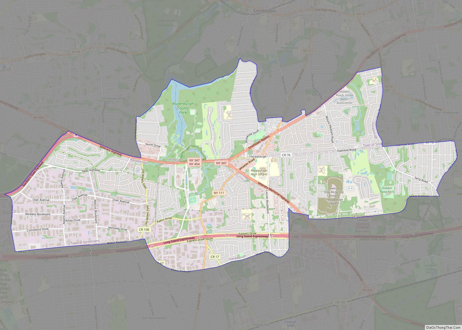
Map of Hastings-on-Hudson village

Map of Hastings-on-Hudson village

Hastings-on-Hudson is a village in Westchester County located in the southwestern part of the town of Greenburgh in the state of New York, United States. It is located on the eastern bank of the Hudson River, approximately 20 miles (32 km) north of midtown Manhattan in New York City, and is served by a stop on … Read more

Map of Hartwick CDP, New York

Map of Hartwick CDP, New York

Hartwick is a census-designated place (CDP) forming the central settlement of the town of Hartwick in Otsego County, New York, United States. It is located at the corner of CR-11 and NY-205. The population of the CDP was 629 at the 2010 census. Hartwick CDP overview: Name: Hartwick CDP LSAD Code: 57 LSAD Description: CDP … Read more

Map of Hartsdale CDP

Map of Hartsdale CDP

Hartsdale is a hamlet located in the town of Greenburgh, Westchester County, New York, United States. The population was 5,293 at the 2010 census. It is a suburb of New York City. Hartsdale CDP overview: Name: Hartsdale CDP LSAD Code: 57 LSAD Description: CDP (suffix) State: New York County: Westchester County Elevation: 184 ft (56 m) Total … Read more

Map of Harrisville village, New York

Map of Harrisville village, New York

Harrisville is a hamlet and former village in Lewis County, New York, United States. The community is now a census-designated place. The population was 628 at the 2010 census. Harrisville is in the northeastern part of the town of Diana and is south of Gouverneur. On May 15, 2018, residents voted to dissolve the village … Read more

Map of Harrison village, New York

Map of Harrison village, New York

Harrison is a town and village in Westchester County, New York, United States, 22 miles (35 km) northeast of Manhattan. The population was 28,218 at the 2020 census. Harrison village overview: Name: Harrison village LSAD Code: 47 LSAD Description: village (suffix) State: New York County: Westchester County Founded: 1696 Elevation: 69 ft (21 m) Total Area: 17.44 sq mi (45.17 km²) … Read more

Map of Harris Hill CDP

Map of Harris Hill CDP

Harris Hill is a hamlet and census-designated place (CDP) located in the town of Clarence in Erie County, New York, United States. The population was 5,508 at the 2010 census. It is part of the Buffalo–Niagara Falls Metropolitan Statistical Area. The region is named after Asa Harris, a former officer in the American Colonial Army, … Read more

Map of Harriman village

Map of Harriman village, New York

Harriman is a village in Orange County, New York, United States. It is in the southeastern section of the town of Monroe, with a small portion in the town of Woodbury. The population was 2,714 at the 2020 census. It is part of the Poughkeepsie–Newburgh–Middletown, NY Metropolitan Statistical Area as well as the larger New … Read more

Map of Haviland CDP, New York

Map of Haviland CDP, New York

Haviland is a community and census-designated place (CDP) in Dutchess County, New York, United States. The population was 3,634 at the 2010 census. It is part of the Poughkeepsie–Newburgh–Middletown, NY Metropolitan Statistical Area as well as the larger New York–Newark–Bridgeport, NY-NJ–CT–PA Combined Statistical Area. Haviland is in the southern portion of the town of Hyde … Read more

Map of Haverstraw village

Map of Haverstraw village

Haverstraw is a village incorporated in 1854 in the town of Haverstraw in Rockland County, New York, United States. It is located north of Congers, southeast of West Haverstraw, east of Garnerville, northeast of New City, and west of the Hudson River at its widest point. According to the 2019 U.S. Census estimate, the population … Read more

Map of Heuvelton village

Map of Heuvelton village

Heuvelton is a small rural, incorporated, village located in St. Lawrence County in the state of New York, United States. It is approximately six miles (9.7 km) southeast of the city of Ogdensburg, in the Town of Oswegatchie. It is the only village in the town. Route 812 bisects the village, and is named State Street … Read more

Map of Herrings CDP

Map of Herrings CDP

Herrings is a hamlet and former village in Jefferson County, New York, United States. The population was 90 at the 2010 census, down from 129 in 2000. The hamlet is named after two brothers who owned a paper mill in the area. Herrings is at the western edge of the town of Wilna and is … Read more

Map of Herricks CDP

Map of Herricks CDP

Herricks is a hamlet and census-designated place (CDP) in Nassau County, on Long Island, in New York, United States. The population was 4,295 at the 2010 census. It is an unincorporated area, and is located in the southern part of Town of North Hempstead. Herricks CDP overview: Name: Herricks CDP LSAD Code: 57 LSAD Description: … Read more