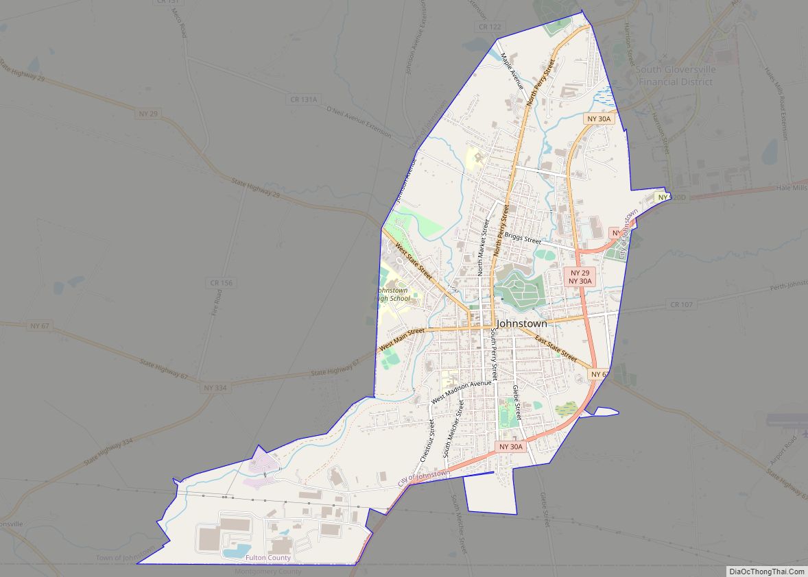
Map of Johnson City village, New York
Johnson City is a village in Broome County, New York, United States. The population was 15,174 at the 2010 census. It is part of the Binghamton Metropolitan Statistical Area. The village of Johnson City is in the town of Union and is a part of the “Triple Cities” along with Endicott and Binghamton. Johnson City ... Read more
Map of Johnson City village, New York
Map of Jericho CDP, New York
Jericho /dʒɛrɪkoʊ/ is a hamlet and census-designated place (CDP) in Nassau County, New York, United States, on the North Shore of Long Island, approximately 29 miles (47 km) east of Midtown Manhattan. Its population was 13,567 as of the U.S. 2010 Census. The area is served by the Jericho Union Free and the Syosset Central School ... Read more
Map of Jericho CDP, New York
Map of Jeffersonville village, New York
Jeffersonville is a village in Sullivan County, New York, United States. The population was 368 at the 2020 census. The name is derived indirectly from Thomas Jefferson. The Village of Jeffersonville is in the southeastern section of the Town of Callicoon on NY 52. The postal code is 12748. The Village of Jeffersonville is home ... Read more
Map of Jeffersonville village, New York
Map of Jefferson Valley-Yorktown CDP
Jefferson Valley-Yorktown, commonly known as Jefferson Valley, is a census-designated place (CDP) located in the town of Yorktown in Westchester County, New York, United States. The population was 14,142 at the 2010 census. It is a hot spot for local shoppers, due to its Jefferson Valley Mall. Jefferson Valley-Yorktown CDP overview: Name: Jefferson Valley-Yorktown CDP ... Read more
Map of Jefferson Valley-Yorktown CDP
Map of Jefferson Heights CDP
Jefferson Heights is a hamlet and census-designated place (CDP) in Greene County, New York, United States. The population was 1,122 at the 2020 census. The community of Jefferson Heights is in the town of Catskill, northwest of the village of Catskill. The building that once housed the community hospital is now a medical arts facility. ... Read more
Map of Jefferson Heights CDP
Map of Jamestown city, New York
Jamestown is a city in southern Chautauqua County, in the U.S. state of New York. The population was 28,712 at the 2020 census. Situated between Lake Erie to the north and the Allegheny National Forest to the south, Jamestown is the largest population center in the county. Nearby Chautauqua Lake is a freshwater resource used ... Read more
Map of Jamestown city, New York
Map of Katonah CDP
Katonah /ˈkətoʊnə/ is a hamlet and census-designated place (CDP) within the town of Bedford, Westchester County, in the U.S. state of New York. The Katonah CDP had a population of 1,679 at the 2010 census. Katonah CDP overview: Name: Katonah CDP LSAD Code: 57 LSAD Description: CDP (suffix) State: New York County: Westchester County Elevation: ... Read more
Map of Katonah CDP
Map of Kingston city, New York
Kingston is the only city in, and the county seat of, Ulster County, New York, United States. It is 91 miles (146 km) north of New York City and 59 miles (95 km) south of Albany. The city’s metropolitan area is grouped with the New York metropolitan area around Manhattan by the United States Census Bureau. The ... Read more
Map of Kingston city, New York
Map of Kings Point village, New York
Kings Point is a village located on the Great Neck Peninsula in the Town of North Hempstead in Nassau County, on the North Shore of Long Island, in New York, United States. The population was 5,005 at the 2010 census. Kings Point village overview: Name: Kings Point village LSAD Code: 47 LSAD Description: village (suffix) ... Read more
Map of Kings Point village, New York
Map of Kings Park CDP, New York
Kings Park is a hamlet and census-designated place (CDP) in the Town of Smithtown, in Suffolk County, on Long Island, in New York, United States. The population was 17,282 as of the 2010 census. Its relative tranquility prompted it to be the site of the Kings Park Psychiatric Center instead of New York City. Kings ... Read more
Map of Kings Park CDP, New York
Map of Kinderhook village, New York
Kinderhook (Kinderhoek in Dutch) is a village in the town of Kinderhook in Columbia County, New York, United States. The village population was 1,211 at the 2010 census. The village of Kinderhook is located in the south-central part of the town on US 9. The eighth President of the United States, Martin Van Buren, was ... Read more
Map of Kinderhook village, New York
Map of Keuka Park CDP
Keuka Park is a hamlet and census-designated place, population 1,137 in 2010 census, in Yates County, New York, United States. The hamlet is on the shore of the east branch of Keuka Lake in the Finger Lakes region. Keuka College is located in Keuka Park next to the lake. Keuka Park CDP overview: Name: Keuka ... Read more
Map of Keuka Park CDP