Map of Melville CDP, New York
Melville is an affluent hamlet and census-designated place (CDP) in the Town of Huntington in Suffolk County on Long Island, New York. The population was 19,284 at the 2020 census. Melville CDP overview: Name: Melville CDP LSAD Code: 57 LSAD Description: CDP (suffix) State: New York County: Suffolk County Elevation: 135 ft (41 m) Total Area: 12.11 sq mi ... Read more
Map of Melville CDP, New York
Map of Melrose Park CDP, New York
Melrose Park is a suburban community and census-designated place (CDP) in Cayuga County, New York, United States. The population was 2,294 at the 2010 census. It is a suburb of Auburn, located south of the city in the town of Owasco. Melrose Park CDP overview: Name: Melrose Park CDP LSAD Code: 57 LSAD Description: CDP ... Read more
Map of Melrose Park CDP, New York
Map of Medina village, New York
Medina /mɪˈdaɪnə/ is a village in the Towns of Shelby and Ridgeway in Orleans County, New York, United States. It is located approximately 10 miles south of Lake Ontario. The population was 6,065 at the 2010 census, making it the county’s most populous municipality. The village was named by its surveyor, Ebenezer Mix. It is ... Read more
Map of Medina village, New York
Map of Medford CDP, New York
Medford is a hamlet and census-designated place (CDP) in the Town of Brookhaven in Suffolk County, on Long Island, in New York, United States. The population was 24,142 at the 2010 census. Medford CDP overview: Name: Medford CDP LSAD Code: 57 LSAD Description: CDP (suffix) State: New York County: Suffolk County Elevation: 89 ft (27 m) Total ... Read more
Map of Medford CDP, New York
Map of Mechanicville city
Mechanicville is a city in Saratoga County, New York, United States. The population was 5,196 at the time of the 2010 census. It is the smallest city by area in the state. The name is derived from the occupations of early residents. The city is located on the eastern border of Saratoga County and is ... Read more
Map of Mechanicville city
Map of Mexico village, New York
Mexico is a village located in the Town of Mexico in Oswego County, New York, United States. The population was 1,624 at the 2010 census. The village is located along New York State Routes 3, 69, and 104. Mexico village overview: Name: Mexico village LSAD Code: 47 LSAD Description: village (suffix) State: New York County: ... Read more
Map of Mexico village, New York
Map of Merritt Park CDP
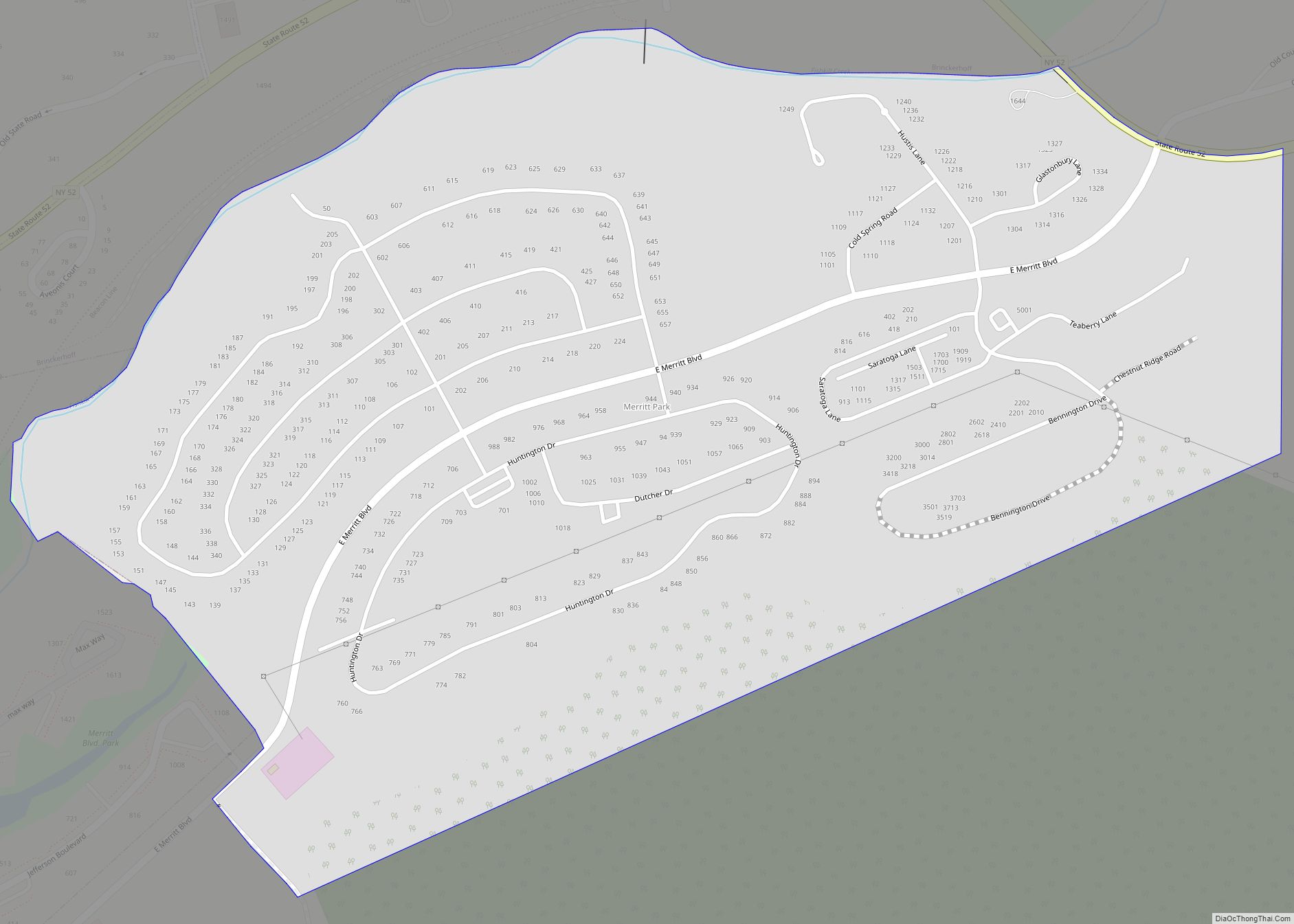
Merritt Park is a census-designated place (CDP) in the town of Fishkill in Dutchess County, New York, United States. As of the 2010 census it had a population of 1,256. The CDP is located in the eastern part of the town of Fishkill in southwestern Dutchess County. It is bordered to the west by the ... Read more
Map of Merritt Park CDP
Map of Millerton village, New York
Millerton is a village in Dutchess County, New York, United States with a population of 903 at the 2020 census. The village was named after Sidney Miller, a rail contractor who helped bring the railroad to that area. Millerton is part of the Poughkeepsie-Newburgh-Middletown Metropolitan Statistical Area of New York as well as the larger ... Read more
Map of Millerton village, New York
Map of Miller Place CDP
Miller Place is a hamlet and census-designated place (CDP) in the Town of Brookhaven, Suffolk County, New York, United States, on the North Shore of Long Island. Miller Place has been inhabited since the 17th century and is named for the Miller family that included many of its initial settlers. For most of its history, ... Read more
Map of Miller Place CDP
Map of Millbrook village, New York
Millbrook is a village in Dutchess County, New York, United States. Millbrook is located in the Hudson Valley, on the east side of the Hudson River, 90 miles (140 km) north of New York City. Millbrook is near the center of the town of Washington, of which it is a part. As of the 2020 census, ... Read more
Map of Millbrook village, New York
Map of Mill Neck village
Mill Neck is a village in the Town of Oyster Bay in Nassau County, on the North Shore of Long Island, in New York, United States. The population was 997 at the 2010 census. Mill Neck village overview: Name: Mill Neck village LSAD Code: 47 LSAD Description: village (suffix) State: New York County: Nassau County ... Read more
Map of Mill Neck village
Map of Milford village, New York
The Village of Milford is a village in the northeastern part of the Town of Milford, in Otsego County, New York, United States. It is located northeast of Oneonta. As of the 2010 census, the village had a population of 415. Milford village overview: Name: Milford village LSAD Code: 47 LSAD Description: village (suffix) State: ... Read more
Map of Milford village, New York