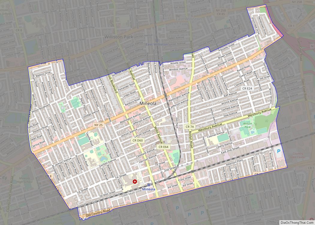
Map of Mohawk village
Mohawk is a village in Herkimer County, New York, United States. The population was 2,731 at the 2010 census. The village was named after the adjacent Mohawk River. The village is at the northern border of the town of German Flatts and adjacent to the Erie Canal. Mohawk is southeast of Utica. Mohawk village overview: ... Read more
Map of Mohawk village
Map of Minoa village
Minoa is a village in Onondaga County, New York, United States. As of the 2020 census, the population was 3,657. Minoa is in the northern part of the town of Manlius and is east of Syracuse. Minoa village overview: Name: Minoa village LSAD Code: 47 LSAD Description: village (suffix) State: New York County: Onondaga County ... Read more
Map of Minoa village
Map of Mineville CDP
Mineville is a hamlet and census-designated place (CDP) in the town of Moriah in Essex County, New York. The population was 1,269 at the 2010 census. Prior to the 2010 census, it was part of the Mineville-Witherbee, New York census-designated place. Mineville and Witherbee are located in the northern part of Moriah, northwest of Port ... Read more
Map of Mineville CDP
Map of Morrisonville CDP, New York
Morrisonville is a hamlet and census-designated place in Clinton County, New York, United States. The population was 1,545 at the 2010 census. Morrisonville is divided between the towns of Plattsburgh and Schuyler Falls by the Saranac River, which defines the boundary between the two towns. The community is west of the city of Plattsburgh. Morrisonville ... Read more
Map of Morrisonville CDP, New York
Map of Morris village, New York
Morris is a village in Otsego County, New York, United States. The population was 583 at the 2010 census. The Village of Morris is centrally located in the Town of Morris and is northwest of the City of Oneonta. Morris village overview: Name: Morris village LSAD Code: 47 LSAD Description: village (suffix) State: New York ... Read more
Map of Morris village, New York
Map of Moriches CDP
Moriches (/moʊˈrɪtʃɪz/ (listen) moh-RITCH-iz) is a hamlet and census-designated place (CDP) in the Suffolk County town of Brookhaven, New York, United States. The population was 2,838 at the 2010 census. Moriches CDP overview: Name: Moriches CDP LSAD Code: 57 LSAD Description: CDP (suffix) State: New York County: Suffolk County Elevation: 23 ft (7 m) Total Area: 2.30 sq mi ... Read more
Map of Moriches CDP
Map of Moravia village, New York
The village of Moravia in Cayuga County, New York, United States is a community with population of about 1,200. The village of Moravia is in the southern part of the town of Moravia and is south of Auburn. Nearby Fillmore Glen State Park contains a replica of the cabin in which President Millard Fillmore was ... Read more
Map of Moravia village, New York
Map of Mooers CDP
Mooers, formerly Mooers-upon-the-Chazy, is a hamlet and census-designated place in the town of Mooers, in Clinton County, New York, United States. The population was 442 at the 2010 census, out of a total population of 3,592 in the town. It was once an incorporated village, but dissolved in 1994. Mooers is in northern New York ... Read more
Map of Mooers CDP
Map of Montrose CDP, New York
Montrose is a hamlet (and census-designated place) within the town of Cortlandt, in the northwestern corner of Westchester County, New York, United States. It is located near Croton-on-Hudson and Buchanan. The rural character of the hamlet is defined by the Hudson River, numerous wooded hills and steep slopes, wetland areas and beautiful streams. As of ... Read more
Map of Montrose CDP, New York
Map of Montour Falls village
Montour Falls is a village located in Schuyler County, New York, United States. The population was 2,714 at the time of the 2020 census. A waterfall at the end of West Main Street gives the village its name. The name “Montour” is derived from Queen Catharine Montour, a prominent Native American woman of Seneca Indian ... Read more
Map of Montour Falls village
Map of Monticello village, New York
Monticello (/ˌmɒntɪˈsɛloʊ/ (listen) MON-tiss-EL-oh) is a village located in Thompson, Sullivan County, within the Catskills region of New York, United States. The population was 7,173 at the 2020 census. It is the seat for the Town of Thompson and the county seat of Sullivan County. The village was named after the residence of Thomas Jefferson. ... Read more
Map of Monticello village, New York
Map of Montgomery village, New York
Montgomery is a village located in Orange County, New York, United States, 60 miles (97 km) northwest of New York City, and 90 miles (140 km) southwest of Albany. The population was 3,834 at the 2020 census. It is part of the Poughkeepsie–Newburgh–Middletown, NY Metropolitan Statistical Area as well as the larger New York–Newark–Bridgeport, NY-NJ–CT–PA Combined Statistical ... Read more
Map of Montgomery village, New York