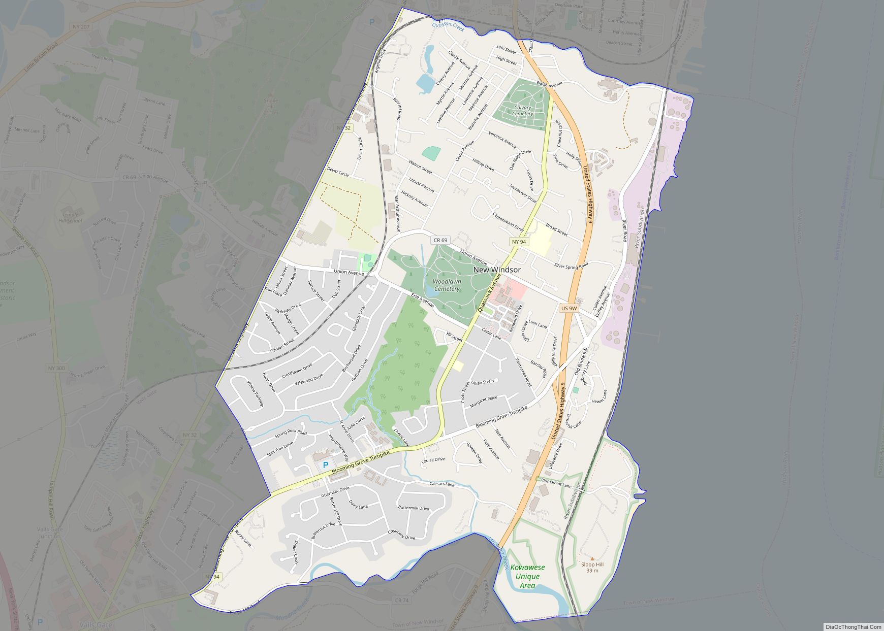
Map of New Square village
New Square (Yiddish: שיכון סקווירא, romanized: Shikun Skvir) is an all-Hasidic village in the town of Ramapo, Rockland County, New York, United States. It is located north of Hillcrest, east of Viola, south of New Hempstead, and west of New City. As of the 2020 United States census, it had a population of 9,679. Its inhabitants ... Read more
Map of New Square village
Map of New Rochelle city
New Rochelle (/ˌnuːrəˈʃɛl/ NEW-Rə-SHEL; older French: La Nouvelle-Rochelle) is a city in Westchester County, New York, United States, in the southeastern portion of the state. In 2020, the city had a population of 79,726, making it the seventh-largest in the state of New York. Some residents refer to the city as New Ro or New ... Read more
Map of New Rochelle city
Map of New Paltz village
New Paltz is a village in Ulster County located in the U.S. state of New York. It is approximately 80 miles (130 km) north of New York City and 70 miles (110 km) south of Albany. The population was 7,324 at the 2020 census. New Paltz is located within the town of New Paltz. It is also ... Read more
Map of New Paltz village
Map of Newfane CDP, New York
Newfane is a census-designated place (CDP) in the town of Newfane in Niagara County, New York, United States, along State Route 78. The population was 3,822 at the 2010 census. It is part of the Buffalo–Niagara Falls Metropolitan Statistical Area. Newfane CDP overview: Name: Newfane CDP LSAD Code: 57 LSAD Description: CDP (suffix) State: New ... Read more
Map of Newfane CDP, New York
Map of Newburgh city, New York
Newburgh is a city in the U.S. state of New York, within Orange County. With a population of 28,856 as of the 2020 census, it is a principal city of the Poughkeepsie–Newburgh–Middletown metropolitan area. Located 60 miles (97 km) north of New York City, and 90 miles (140 km) south of Albany on the Hudson River within ... Read more
Map of Newburgh city, New York
Map of North Babylon CDP
North Babylon is a hamlet and census-designated place (CDP) located in the Town of Babylon in Suffolk County, on the South Shore of Long Island, in New York, United States. The population was 17,509 at the 2010 census. North Babylon CDP overview: Name: North Babylon CDP LSAD Code: 57 LSAD Description: CDP (suffix) State: New ... Read more
Map of North Babylon CDP
Map of North Amityville CDP
North Amityville is a hamlet and census-designated place (CDP) in the Town of Babylon in Suffolk County, on the South Shore of Long Island, in New York. The population was 18,643 at the 2020 Census. North Amityville CDP overview: Name: North Amityville CDP LSAD Code: 57 LSAD Description: CDP (suffix) State: New York County: Suffolk ... Read more
Map of North Amityville CDP
Map of Norfolk CDP, New York
Norfolk is a hamlet (and census-designated place) in St. Lawrence County, New York, United States. The population was 1,327 at the 2010 census. This community is in the Town of Norfolk. Norfolk CDP overview: Name: Norfolk CDP LSAD Code: 57 LSAD Description: CDP (suffix) State: New York County: St. Lawrence County Elevation: 259 ft (79 m) Total ... Read more
Map of Norfolk CDP, New York
Map of Niverville CDP
Niverville is a semi-rural hamlet and census-designated place (CDP) in northern Columbia County, New York, United States. The hamlet of Niverville is located in the town of Kinderhook, south of Kinderhook Lake. The Niverville CDP includes the hamlet as well as all of the land surrounding Kinderhook Lake, extending east into the town of Chatham. ... Read more
Map of Niverville CDP
Map of Nissequogue village
Nissequogue (/ˈnɪsəkwɒɡ/) is a village in Suffolk County, on the North Shore of Long Island, in New York, United States. The village population was 1,564 at the 2020 census. The Incorporated Village of Nissequogue is located entirely within the Town of Smithtown. Nissequogue village overview: Name: Nissequogue village LSAD Code: 47 LSAD Description: village (suffix) ... Read more
Map of Nissequogue village
Map of Niskayuna CDP
Niskayuna is a hamlet (and census-designated place) in Schenectady County, New York, United States. The population was 4,859 at the 2010 census. The hamlet of Niskayuna is in the town of Niskayuna. Niskayuna CDP overview: Name: Niskayuna CDP LSAD Code: 57 LSAD Description: CDP (suffix) State: New York County: Schenectady County Elevation: 292 ft (89 m) Total ... Read more
Map of Niskayuna CDP
Map of Nichols village, New York
Nichols is a village located in the Town of Nichols in Tioga County, New York, United States. The population was 512 at the 2010 census. It is part of the Binghamton Metropolitan Statistical Area. The name is taken from that of a local benefactor, Colonel Nichols. The Village of Nichols is on the northern border ... Read more
Map of Nichols village, New York