Map of Plainview CDP, New York

Map of Plainview CDP, New York

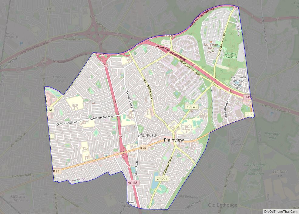
Plainview is a hamlet and census-designated place (CDP) located near the North Shore of Long Island in the town of Oyster Bay in Nassau County, New York, United States. The population of the CDP as of 2020 was 27,100. The Plainview post office has the ZIP code 11803. Plainview and its neighboring hamlet, Old Bethpage, … Read more

Map of Plainedge CDP

Map of Plainedge CDP

Plainedge is a hamlet and census-designated place (CDP) in the Town of Oyster Bay in Nassau County, on Long Island, in New York, United States. The population was 8,817 at the 2010 census. The area was once known as Turkeyville. Plainedge CDP overview: Name: Plainedge CDP LSAD Code: 57 LSAD Description: CDP (suffix) State: New … Read more

Map of Pittsford village

Map of Pittsford village, New York

Pittsford is a village in Monroe County, New York, United States. The population was 1,355 at the 2010 census. It is named after Pittsford, Vermont, the native town of a founding father. The Village of Pittsford is the oldest village in New York, incorporated in 1827. The village, an Erie Canal community, is in the … Read more

Map of Pine Valley CDP, New York

Map of Pine Valley CDP, New York

Pine Valley is a hamlet and census-designated place in the towns of Catlin and Veteran in Chemung County, New York, United States. The population was 813 at the 2010 census. Pine Valley CDP overview: Name: Pine Valley CDP LSAD Code: 57 LSAD Description: CDP (suffix) State: New York County: Chemung County Elevation: 930 ft (280 m) Total … Read more

Map of Pine Plains CDP

Map of Pine Plains CDP

Pine Plains is a hamlet and census-designated place (CDP) in Dutchess County, New York, United States. The population was 1,142 at the 2020 census. It is part of the Poughkeepsie–Newburgh–Middletown, NY Metropolitan Statistical Area as well as the larger New York–Newark–Bridgeport, NY-NJ–CT–PA Combined Statistical Area. The community of Pine Plains is in the town of … Read more

Map of Point Lookout CDP

Map of Point Lookout CDP

Point Lookout is a hamlet and census-designated place (CDP) located in the town of Hempstead in Nassau County, New York, United States. The population was 1,219 at the time of the 2010 census. The town is mostly made up of residential homes, with several small businesses on Lido Boulevard. The town is surrounded on three … Read more

Map of Poestenkill CDP

Map of Poestenkill CDP

Poestenkill is a hamlet (and census-designated place) in Rensselaer County, New York, United States. The population was 1,061 at the 2010 census. The name is taken from Poesten Kill, a stream in the area. Poestenkill is in the southern part of the Town of Poestenkill. Poestenkill CDP overview: Name: Poestenkill CDP LSAD Code: 57 LSAD … Read more

Map of Plessis CDP

Map of Plessis CDP

Plessis is a hamlet and census-designated place in the town of Alexandria in Jefferson County, New York, United States. Its population was 164 as of the 2010 census. Plessis had a post office from September 16, 1823, until March 26, 2011; it still has its own ZIP code, 13675. New York State Route 26 passes … Read more

Map of Pleasantville village, New York

Map of Pleasantville village, New York

Pleasantville is a village in the town of Mount Pleasant, in Westchester County, New York, United States. It is located 30 miles north of Manhattan. The village population was 7,019 at the 2010 census. Pleasantville is home to the secondary campus of Pace University and to the Jacob Burns Film Center. Most of Pleasantville is … Read more

Map of Pleasant Valley CDP, New York

Map of Pleasant Valley CDP, New York

Pleasant Valley is a census-designated place (CDP) in the southwestern part of the town of Pleasant Valley in Dutchess County, New York, United States. The population was 1,145 at the 2010 census. It is part of the Poughkeepsie–Newburgh–Middletown, NY Metropolitan Statistical Area as well as the larger New York–Newark–Bridgeport, NY-NJ–CT–PA Combined Statistical Area. Pleasant Valley … Read more

Map of Plattsburgh city

Map of Plattsburgh city

Plattsburgh (Mohawk: Tsi ietsénhtha) is a city in, and the seat of, Clinton County, New York, United States, situated on the north-western shore of Lake Champlain. The population was 19,841 at the 2020 census. The population of the surrounding (and separately incorporated) Town of Plattsburgh was 11,886 as of the 2020 census, making the combined … Read more

Map of Plattsburgh West CDP

Map of Plattsburgh West CDP

Plattsburgh West is a census-designated place (CDP) and region of the town of Plattsburgh in Clinton County, New York, United States. The population was 1,364 at the 2010 census. The CDP lies to the west of the city of Plattsburgh. Plattsburgh West CDP overview: Name: Plattsburgh West CDP LSAD Code: 57 LSAD Description: CDP (suffix) … Read more