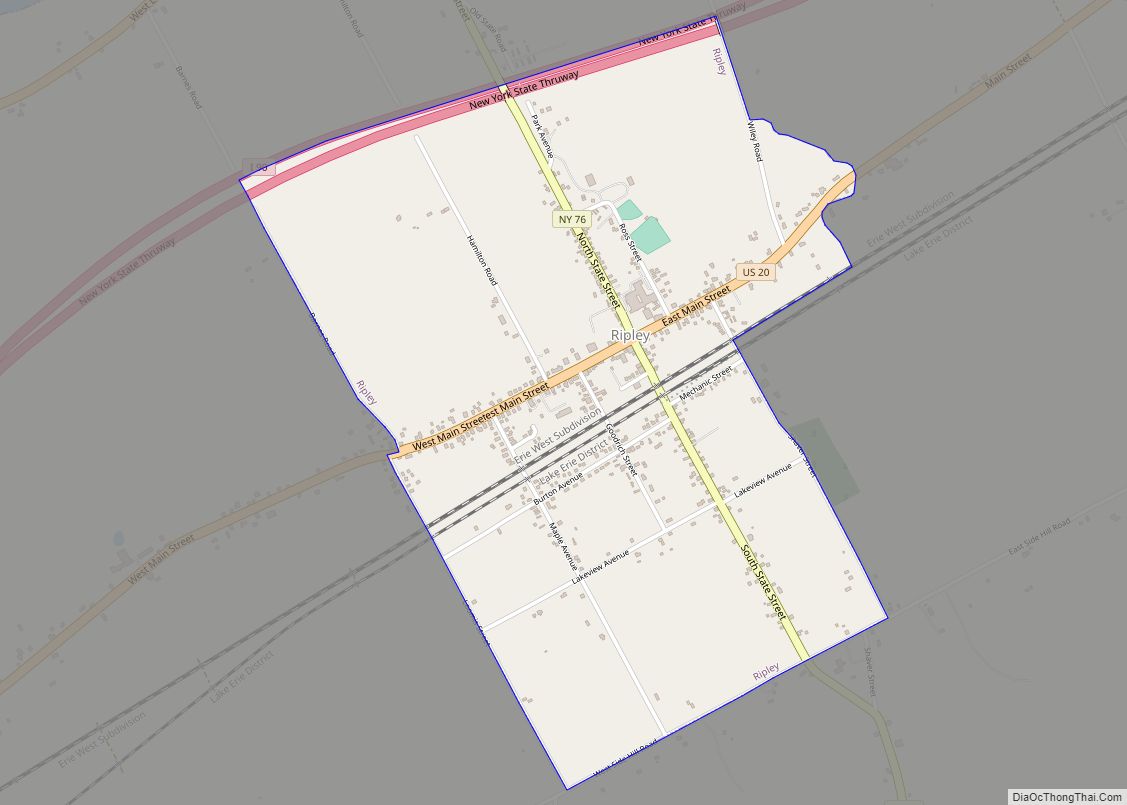
Map of Richfield Springs village
Richfield Springs is a village located in the Town of Richfield, on the north-central border of Otsego County, New York, United States. The population was 1,264 at the 2010 census. The name is derived from local sulfur springs. Richfield Springs village overview: Name: Richfield Springs village LSAD Code: 47 LSAD Description: village (suffix) State: New ... Read more
Map of Richfield Springs village
Map of Richburg village, New York
Richburg is a village in Allegany County, New York, United States. The population was 450 at the 2010 census. The village is partly within the boundaries of the towns of Wirt and Bolivar. The community is east of Olean. Richburg village overview: Name: Richburg village LSAD Code: 47 LSAD Description: village (suffix) State: New York ... Read more
Map of Richburg village, New York
Map of Rhinecliff CDP
Rhinecliff is a hamlet and census-designated place (CDP) located along the Hudson River in the town of Rhinebeck in northern Dutchess County, New York, United States. As of the 2010 census, the population of Rhinecliff was 425. Rhinecliff CDP overview: Name: Rhinecliff CDP LSAD Code: 57 LSAD Description: CDP (suffix) State: New York County: Dutchess ... Read more
Map of Rhinecliff CDP
Map of Rhinebeck village
Rhinebeck is a village in the town of Rhinebeck in Dutchess County, New York, United States. The population was 2,657 at the 2010 census. It is part of the Poughkeepsie–Newburgh–Middletown, NY Metropolitan Statistical Area as well as the larger New York–Newark–Connecticut. The postal ZIP code is 12572. U.S. Route 9 passes through the village. Rhinebeck ... Read more
Map of Rhinebeck village
Map of Retsof CDP
Retsof is a hamlet and census-designated place (CDP) within the town of York in Livingston County, New York, United States. The community, situated 30 miles (48 km) southwest of the city of Rochester, is off New York State Route 63 approximately one mile east of State Route 36. As of the 2010 census, it had a ... Read more
Map of Retsof CDP
Map of Riverhead CDP
Riverhead is a census-designated place (CDP) roughly corresponding to the hamlet by the same name located in the Town of Riverhead in Suffolk County, on Long Island, in New York, United States. The CDP’s population was 13,299 at the 2010 census. Situated at the mouth of the Peconic River, which empties into Peconic Bay where ... Read more
Map of Riverhead CDP
Map of Roosevelt CDP, New York
Roosevelt (historically known as Greenwich and Rum Point) is a hamlet and census-designated place (CDP) in the Town of Hempstead in Nassau County, on the South Shore of Long Island, in New York, United States. The population was 18,066 at the 2020 census. Roosevelt CDP overview: Name: Roosevelt CDP LSAD Code: 57 LSAD Description: CDP ... Read more
Map of Roosevelt CDP, New York
Map of Ronkonkoma CDP
Ronkonkoma (/rɒnˈkɒŋkəmə/ ron-KONG-kə-mə) is a hamlet and census-designated place (CDP) in the Town of Islip in Suffolk County, on Long Island, in New York, United States. The population was 19,082 at the 2010 census. The Ronkonkoma post office has the ZIP Code 11779, and serves parts of several hamlets and CDPs adjacent to Ronkonkoma. Ronkonkoma ... Read more
Map of Ronkonkoma CDP
Map of Romulus CDP, New York
Romulus is a hamlet (and census-designated place) located in the Town of Romulus, Seneca County, New York, United States on the border with the Town of Varick. The population was 409 at the 2010 census. The hamlet was originally called “Romulusville.” It was renamed Romulus, after the town, circa 1870. Romulus CDP overview: Name: Romulus ... Read more
Map of Romulus CDP, New York
Map of Rome city, New York
Rome is a city in Oneida County, New York, United States, located in the central part of the state. The population was 32,127 at the 2020 census. Rome is one of two principal cities in the Utica–Rome Metropolitan Statistical Area, which lies in the “Leatherstocking Country” made famous by James Fenimore Cooper’s Leatherstocking Tales, set ... Read more
Map of Rome city, New York
Map of Rodman CDP, New York
Rodman is a hamlet and census-designated place (CDP) in the town of Rodman, Jefferson County, New York, United States. As of the 2010 census, the CDP population was 153, out of 1,176 in the entire town of Rodman. Rodman CDP overview: Name: Rodman CDP LSAD Code: 57 LSAD Description: CDP (suffix) State: New York County: ... Read more
Map of Rodman CDP, New York
Map of Rocky Point CDP, New York
Rocky Point is a hamlet and census-designated place (CDP) in the town of Brookhaven, New York, United States. As of the 2010 United States census, the CDP population was 14,014. Rocky Point CDP overview: Name: Rocky Point CDP LSAD Code: 57 LSAD Description: CDP (suffix) State: New York County: Suffolk County Elevation: 194 ft (59 m) Total ... Read more
Map of Rocky Point CDP, New York