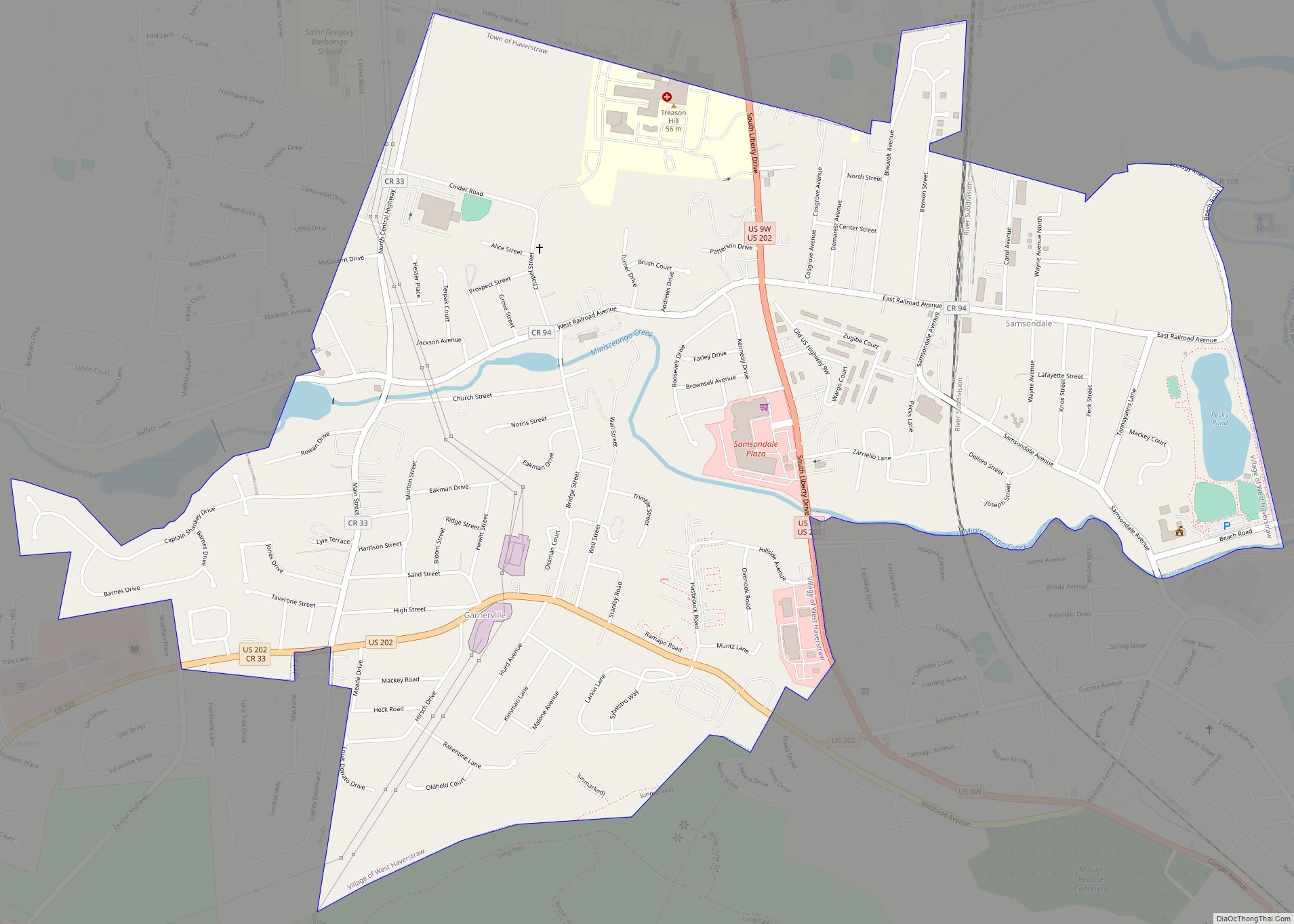
Map of West Chazy CDP

Map of West Chazy CDP

West Chazy is a hamlet and census-designated place in the town of Chazy in Clinton County, New York, United States. The population was 529 at the 2010 census. West Chazy CDP overview: Name: West Chazy CDP LSAD Code: 57 LSAD Description: CDP (suffix) State: New York County: Clinton County Elevation: 290 ft (90 m) Total Area: 1.88 sq mi … Read more

Map of West Carthage village

Map of West Carthage village

West Carthage is a village in Jefferson County, New York, United States. The population was 2,012 at the 2010 census. West Carthage is in the town of Champion, next to the eastern town line, and is east of Watertown. West Carthage is adjacent to the village of Carthage and is south of Fort Drum. West … Read more

Map of West Bay Shore CDP

Map of West Bay Shore CDP

West Bay Shore is a hamlet and census-designated place (CDP) in the Town of Islip, Suffolk County, New York, United States. Its population was 4,648 at the 2010 census. West Bay Shore CDP overview: Name: West Bay Shore CDP LSAD Code: 57 LSAD Description: CDP (suffix) State: New York County: Suffolk County Elevation: 13 ft (4 m) … Read more

Map of West Babylon CDP

Map of West Babylon CDP

West Babylon is a census-designated place (CDP) in the Town of Babylon in Suffolk County, New York, United States. The population was 43,213 at the 2010 census. West Babylon CDP overview: Name: West Babylon CDP LSAD Code: 57 LSAD Description: CDP (suffix) State: New York County: Suffolk County Elevation: 39 ft (12 m) Total Area: 8.77 sq mi (22.70 km²) … Read more

Map of Wesley Hills village

Map of Wesley Hills village

Wesley Hills is a village in the town of Ramapo, Rockland County, New York, United States. It is located north of Viola, east of Harriman State Park, south of Pomona, and west of New Hempstead. The population was 5,628 at the 2010 census. Joseph Berger of The New York Times said in a 1997 article … Read more

Map of West Hurley CDP

Map of West Hurley CDP

West Hurley is a hamlet (and census-designated place) in Ulster County, New York, United States. The population was 1,917 at the 2020 census. West Hurley is located in the Town of Hurley and is inside the Catskill Park. The community is northwest of Kingston on Route 28. It was one of many villages that were … Read more

Map of West Hills CDP

Map of West Hills CDP, New York

West Hills is a hamlet and census-designated place (CDP) in the Town of Huntington, Suffolk County, New York. The population was 5,592 at the 2010 census. Residents share a post office with the hamlet of Huntington but much earlier in its history, West Hills had its own post office, located on Jericho Turnpike (formerly Middle … Read more

Map of West Hempstead CDP

Map of West Hempstead CDP

West Hempstead is a hamlet and census-designated place (CDP) in the Town of Hempstead in Nassau County, on Long Island, in New York, United States. The population was 19,835 at the 2020 census. It is an unincorporated area in the Town of Hempstead and is represented by Councilman Edward Ambrosino. The residents in the hamlet … Read more

Map of West Valley CDP

Map of West Valley CDP

West Valley is a hamlet in the Town of Ashford in Cattaraugus County, New York, United States. The population was 518 at the 2010 census, which lists the community as a census-designated place. Located at the intersection of Cattaraugus County Route 53 and State Route 240/County Route 32, the hamlet is home to West Valley … Read more

Map of West Seneca CDP

Map of West Seneca CDP

West Seneca is a hamlet and census-designated place (CDP) in Erie County, New York, United States. The population was 44,711 at the 2010 census. It is part of the Buffalo–Niagara Falls Metropolitan Statistical Area. The CDP corresponds exactly to the area of the town of West Seneca. West Seneca CDP overview: Name: West Seneca CDP … Read more

Map of West Sayville CDP

Map of West Sayville CDP

West Sayville is a hamlet and census-designated place (CDP) in Suffolk County, New York, United States. It had a population of 5,011 at the 2010 census. West Sayville CDP overview: Name: West Sayville CDP LSAD Code: 57 LSAD Description: CDP (suffix) State: New York County: Suffolk County Elevation: 13 ft (4 m) Total Area: 2.11 sq mi (5.47 km²) Land … Read more

Map of West Sand Lake CDP

Map of West Sand Lake CDP

West Sand Lake is a hamlet and census-designated place in Rensselaer County, New York, United States. The population was 2,845 people in 2015. The community is located in the northwestern corner of the town of Sand Lake. West Sand Lake CDP overview: Name: West Sand Lake CDP LSAD Code: 57 LSAD Description: CDP (suffix) State: … Read more