Map of Cape Carteret town

Map of Cape Carteret town

Cape Carteret is a town in Carteret County, on the southern coast of North Carolina, United States. It was incorporated in 1959 and had a population of 2,224 as of the 2020 census. Cape Carteret town overview: Name: Cape Carteret town LSAD Code: 43 LSAD Description: town (suffix) State: North Carolina County: Carteret County Elevation: … Read more

Map of Canton town, North Carolina

Map of Canton town, North Carolina

Canton is the second largest town in Haywood County, North Carolina, United States. It is located about 17 miles (27 km) west of Asheville and is part of that city’s metropolitan area. The town is named after the city of Canton, Ohio. The population was 4,227 at the 2010 census. Canton town overview: Name: Canton town … Read more

Map of Candor town

Map of Candor town, North Carolina

Candor is a town in Montgomery County, North Carolina, United States. The population was 840 at the 2010 census. Candor is the home of the North Carolina Peach Festival, which is held every year on the third Saturday of July. The town’s welcome sign reads: Welcome to Candor. Peach Capital. Candor town overview: Name: Candor … Read more

Map of Cameron town, North Carolina

Map of Cameron town, North Carolina

Cameron is a town in Moore County, North Carolina, United States. The population was 359 at the 2020 census. Cameron town overview: Name: Cameron town LSAD Code: 43 LSAD Description: town (suffix) State: North Carolina County: Moore County Founded: 1875 Incorporated: 1876 Elevation: 358 ft (109 m) Total Area: 1.21 sq mi (3.14 km²) Land Area: 1.21 sq mi (3.14 km²) Water Area: … Read more

Map of Casar town

Map of Casar town

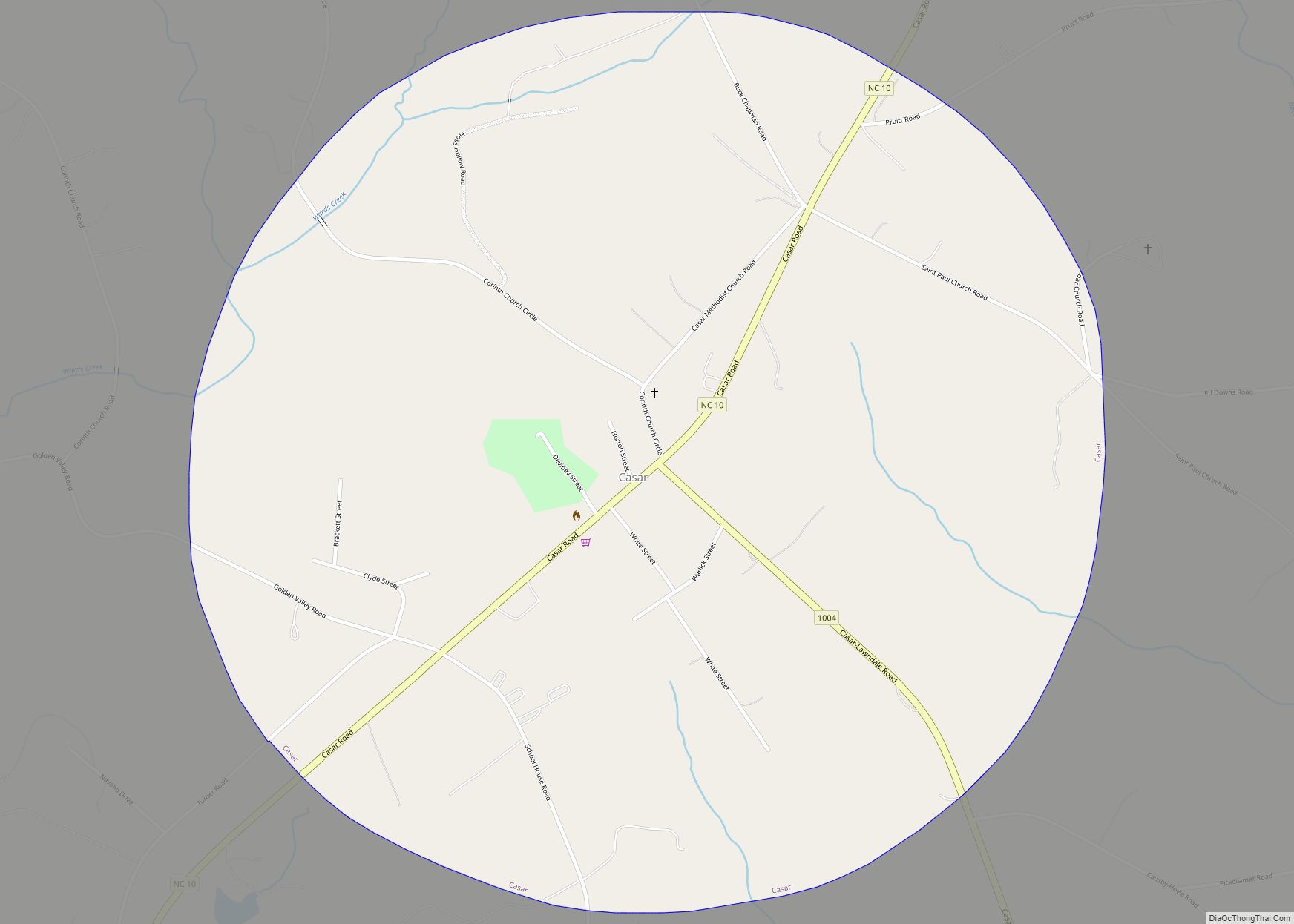
Casar is a small town in northern Cleveland County, North Carolina, United States. The population was 297 at the 2010 census. Casar town overview: Name: Casar town LSAD Code: 43 LSAD Description: town (suffix) State: North Carolina County: Cleveland County Elevation: 1,148 ft (350 m) Total Area: 1.75 sq mi (4.53 km²) Land Area: 1.75 sq mi (4.53 km²) Water Area: 0.00 sq mi (0.00 km²) … Read more

Map of Carthage town, North Carolina

Map of Carthage town, North Carolina

Carthage is the county seat of Moore County, North Carolina, United States. The population was 2,635 at the 2020 Census. The city is named after Carthage. Carthage town overview: Name: Carthage town LSAD Code: 43 LSAD Description: town (suffix) State: North Carolina County: Moore County Founded: 1796 Incorporated: 1796 Elevation: 617 ft (188 m) Total Area: 6.70 sq mi … Read more

Map of Carrboro town

Map of Carrboro town

Carrboro is a town in Orange County in the U.S. state of North Carolina. The population was 21,295 at the 2020 census. The town, which is part of the Raleigh-Durham-Chapel Hill combined statistical area, was named after North Carolina industrialist Julian Shakespeare Carr (who never lived in Carrboro). Located directly west of Chapel Hill, home … Read more

Map of Carolina Shores town

Map of Carolina Shores town

Carolina Shores is a town in Brunswick County, North Carolina, United States. The population was 3,048 at the 2010 census, up from 1,482 in 2000. It is part of the Myrtle Beach metropolitan area. The town was incorporated in 1998 after a split from the town of Calabash, which came as the result of years … Read more

Map of Carolina Beach town

Map of Carolina Beach town

Carolina Beach is a beach town in New Hanover County, North Carolina, United States, situated about 12 miles (19 km) south of Wilmington International Airport in southeastern coastal North Carolina. As of the 2020 census, the city population was 6,564. It is part of the Wilmington metropolitan area. The community of Wilmington Beach was annexed by … Read more

Map of Caroleen CDP

Map of Caroleen CDP

Caroleen is an unincorporated community and census-designated place (CDP) in southeastern Rutherford County, North Carolina, United States. Its population was 652 as of the 2010 census. Caroleen has a post office with ZIP code 28019. U.S. Route 221 Alternate passes through the community. Caroleen CDP overview: Name: Caroleen CDP LSAD Code: 57 LSAD Description: CDP … Read more

Map of Chadbourn town

Map of Chadbourn town

Chadbourn is a town in Columbus County, North Carolina, United States. The population was 1,856 at the 2010 census. Chadbourn town overview: Name: Chadbourn town LSAD Code: 43 LSAD Description: town (suffix) State: North Carolina County: Columbus County Elevation: 105 ft (32 m) Total Area: 2.60 sq mi (6.74 km²) Land Area: 2.60 sq mi (6.74 km²) Water Area: 0.00 sq mi (0.00 km²) Total Population: … Read more

Map of Cerro Gordo town, North Carolina

Map of Cerro Gordo town, North Carolina

Cerro Gordo is a town in Columbus County, North Carolina, United States. The population was 207 at the 2010 census. Cerro Gordo town overview: Name: Cerro Gordo town LSAD Code: 43 LSAD Description: town (suffix) State: North Carolina County: Columbus County Elevation: 89 ft (27 m) Total Area: 0.79 sq mi (2.05 km²) Land Area: 0.79 sq mi (2.05 km²) Water Area: 0.00 sq mi … Read more