Map of Gerton CDP
Gerton is an unincorporated community and census-designated place (CDP) in Henderson County, North Carolina, United States. As of the 2010 census it had a population of 254. It is part of the Asheville Metropolitan Statistical Area. Gerton CDP overview: Name: Gerton CDP LSAD Code: 57 LSAD Description: CDP (suffix) State: North Carolina County: Henderson County ... Read more
Map of Gerton CDP
Map of Germanton CDP
Germanton is an unincorporated community and census-designated place (CDP) in Forsyth and Stokes counties in the U.S. state of North Carolina, primarily in Stokes County. As of the 2010 census it had a population of 827. It is located 13 miles (21 km) south of the Stokes County seat of Danbury, on North Carolina State Highways ... Read more
Map of Germanton CDP
Map of Gatesville town, North Carolina
Gatesville is a town in Gates County, North Carolina, United States. The population was 321 at the 2010 census. It is the county seat of Gates County. Gatesville town overview: Name: Gatesville town LSAD Code: 43 LSAD Description: town (suffix) State: North Carolina County: Gates County Elevation: 23 ft (7 m) Total Area: 0.40 sq mi (1.05 km²) Land Area: ... Read more
Map of Gatesville town, North Carolina
Map of Gastonia city
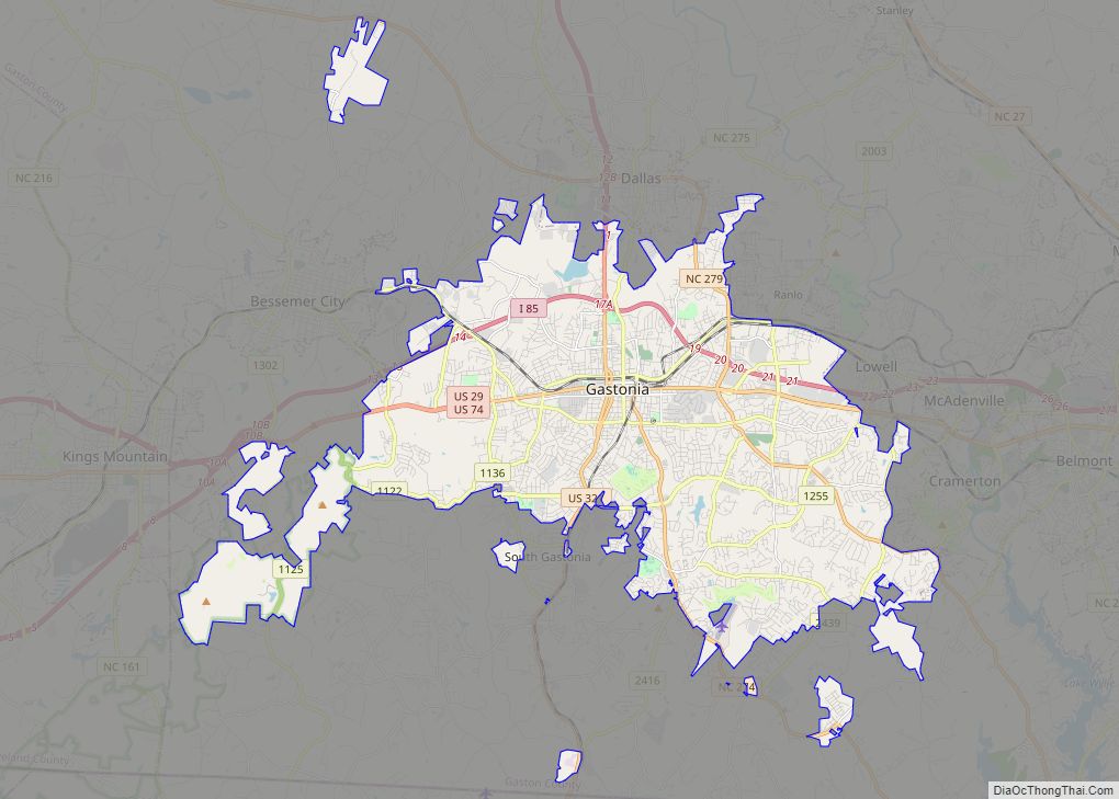
Gastonia is the largest city in and county seat of Gaston County, North Carolina, United States. It is the second-largest satellite city of the Charlotte area, behind Concord. The population was 80,411 in the 2020 census, up from 71,741 in 2010. Gastonia is the 13th most populous city in North Carolina. It is part of ... Read more
Map of Gastonia city
Map of Gaston town, North Carolina
Gaston is a town in Northampton County, North Carolina, United States. The population was 1,152 at the 2010 census. It is part of the Roanoke Rapids, North Carolina Micropolitan Statistical Area. Gaston town overview: Name: Gaston town LSAD Code: 43 LSAD Description: town (suffix) State: North Carolina County: Northampton County Elevation: 177 ft (54 m) Total Area: ... Read more
Map of Gaston town, North Carolina
Map of Garysburg town
Garysburg is a town in Northampton County, North Carolina, United States. The population was 1,057 at the 2010 census. It is part of the Roanoke Rapids, North Carolina Micropolitan Statistical Area. Garysburg town overview: Name: Garysburg town LSAD Code: 43 LSAD Description: town (suffix) State: North Carolina County: Northampton County Elevation: 135 ft (41 m) Total Area: ... Read more
Map of Garysburg town
Map of Gorman CDP, North Carolina
Gorman is a census-designated place (CDP) in Durham County, North Carolina, United States. The population was 1,011 at the 2010 census. Gorman CDP overview: Name: Gorman CDP LSAD Code: 57 LSAD Description: CDP (suffix) State: North Carolina County: Durham County Elevation: 361 ft (110 m) Total Area: 2.96 sq mi (7.66 km²) Land Area: 2.90 sq mi (7.51 km²) Water Area: 0.06 sq mi (0.14 km²) ... Read more
Map of Gorman CDP, North Carolina
Map of Goldston town
Goldston town overview: Name: Goldston town LSAD Code: 43 LSAD Description: town (suffix) State: North Carolina County: Chatham County FIPS code: 3726920 Online Interactive Map Goldston online map. Source: Basemap layers from Google Map, Open Street Map (OSM), Arcgisonline, Wmflabs. Boundary Data from Database of Global Administrative Areas. Goldston location map. Where is Goldston town? ... Read more
Map of Goldston town
Map of Goldsboro city, North Carolina
Goldsboro, originally Goldsborough, is a city and the county seat of Wayne County, North Carolina, United States. The population was 33,657 at the 2020 census. It is the principal city of and is included in the Goldsboro, North Carolina Metropolitan Statistical Area. The nearby town of Waynesboro was founded in 1787, and Goldsboro was incorporated ... Read more
Map of Goldsboro city, North Carolina
Map of Godwin town
Godwin is a town in Cumberland County, North Carolina, United States. The population was 139 at the 2010 census. Godwin town overview: Name: Godwin town LSAD Code: 43 LSAD Description: town (suffix) State: North Carolina County: Cumberland County Elevation: 154 ft (47 m) Total Area: 0.63 sq mi (1.63 km²) Land Area: 0.63 sq mi (1.63 km²) Water Area: 0.00 sq mi (0.00 km²) Total Population: ... Read more
Map of Godwin town
Map of Gloucester CDP, North Carolina
Gloucester is an unincorporated area and census-designated place (CDP) in Carteret County, North Carolina, United States. As of the 2010 census it had a population of 537. Gloucester CDP overview: Name: Gloucester CDP LSAD Code: 57 LSAD Description: CDP (suffix) State: North Carolina County: Carteret County Elevation: 6 ft (2 m) Total Area: 1.45 sq mi (3.76 km²) Land Area: ... Read more
Map of Gloucester CDP, North Carolina
Map of Glenville CDP, North Carolina
Glenville is an unincorporated community and census-designated place (CDP) in Jackson County, North Carolina, United States. It is now a popular lakeside vacation community with many second homes that sometimes are rented around Lake Glenville, which flooded and destroyed the original town. As of the 2010 census, the year-round population was 110. Glenville CDP overview: ... Read more
Map of Glenville CDP, North Carolina