Map of Holden Beach town
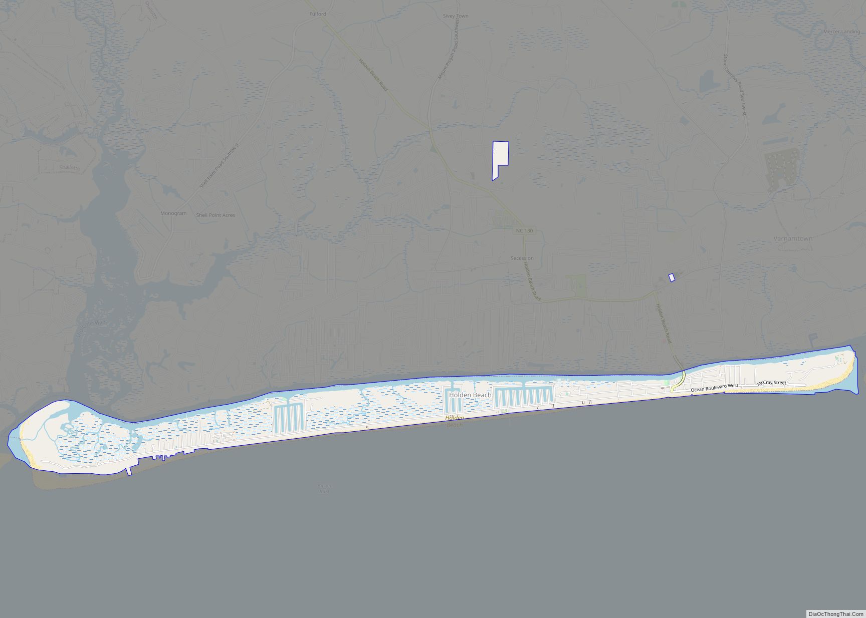
Holden Beach is a seaside town in Brunswick County, North Carolina. The population was 575 at the time of the 2010 census. It is part of the Myrtle Beach metropolitan area. Holden Beach town overview: Name: Holden Beach town LSAD Code: 43 LSAD Description: town (suffix) State: North Carolina County: Brunswick County Incorporated: 1969 Elevation: ... Read more
Map of Holden Beach town
Map of Hoffman town, North Carolina
Hoffman is a town in Richmond County, North Carolina, United States. The population was 588 at the 2010 census. It was named for a family of settlers. Hoffman town overview: Name: Hoffman town LSAD Code: 43 LSAD Description: town (suffix) State: North Carolina County: Richmond County Elevation: 459 ft (140 m) Total Area: 3.40 sq mi (8.81 km²) Land Area: ... Read more
Map of Hoffman town, North Carolina
Map of Hobucken CDP
Hobucken is an unincorporated community and census-designated place (CDP) in Pamlico County, North Carolina, United States. Its population was 38 as of the 2020 census. Hobucken has a post office with ZIP code 28537. North Carolina Highway 33 and North Carolina Highway 304 pass through in the community. Hobucken CDP overview: Name: Hobucken CDP LSAD ... Read more
Map of Hobucken CDP
Map of Horse Shoe CDP
Horse Shoe is an unincorporated community and census-designated place (CDP) in Henderson County, North Carolina, United States. Its ZIP code is 28742. As of the 2010 census, its population was 2,351. The community took its name from a nearby meander in the French Broad River. Horse Shoe CDP overview: Name: Horse Shoe CDP LSAD Code: ... Read more
Map of Horse Shoe CDP
Map of Hope Mills town
Hope Mills is a town in Cumberland County, North Carolina, United States. Its population was 15,176 at the 2010 census. Hope Mills town overview: Name: Hope Mills town LSAD Code: 43 LSAD Description: town (suffix) State: North Carolina County: Cumberland County Elevation: 108 ft (33 m) Total Area: 8.64 sq mi (22.38 km²) Land Area: 8.48 sq mi (21.96 km²) Water Area: 0.16 sq mi ... Read more
Map of Hope Mills town
Map of Hoopers Creek CDP
Hoopers Creek is an unincorporated community and census-designated place (CDP) in Henderson County, North Carolina, United States. Its population was 1,056 as of the 2010 census. Hoopers Creek CDP overview: Name: Hoopers Creek CDP LSAD Code: 57 LSAD Description: CDP (suffix) State: North Carolina County: Henderson County Elevation: 2,159 ft (658 m) Total Area: 6.95 sq mi (18.01 km²) Land ... Read more
Map of Hoopers Creek CDP
Map of JAARS CDP
Jaars, capitalized as JAARS on some maps, is a census-designated place (CDP) in Union County, North Carolina, United States. The population was 597 at the 2010 census. The region’s name comes from JAARS, a non-profit organization that is located there. JAARS CDP overview: Name: JAARS CDP LSAD Code: 57 LSAD Description: CDP (suffix) State: North ... Read more
Map of JAARS CDP
Map of Ivanhoe CDP, North Carolina
Ivanhoe is a census-designated place (CDP) in Sampson County, North Carolina, United States. The population was 198 at the 2020 census. Ivanhoe CDP overview: Name: Ivanhoe CDP LSAD Code: 57 LSAD Description: CDP (suffix) State: North Carolina County: Sampson County Elevation: 30 ft (10 m) Total Area: 5.03 sq mi (13.03 km²) Land Area: 5.02 sq mi (13.01 km²) Water Area: 0.01 sq mi (0.02 km²) ... Read more
Map of Ivanhoe CDP, North Carolina
Map of Iron Station CDP
Iron Station is an unincorporated community and census-designated place (CDP) in Lincoln County, North Carolina, United States. A primarily industrial town, Iron Station’s population was 755 as of the 2010 census. It also serves as a bedroom community for the larger cities of Charlotte, Hickory, and Lincolnton. The Iron Station post office has a ZIP ... Read more
Map of Iron Station CDP
Map of Ingold CDP
Ingold is a census-designated place (CDP) in Sampson County, North Carolina, United States. The population was 484 at the 2000 census. Ingold CDP overview: Name: Ingold CDP LSAD Code: 57 LSAD Description: CDP (suffix) State: North Carolina County: Sampson County Elevation: 102 ft (31 m) Total Area: 5.19 sq mi (13.44 km²) Land Area: 5.18 sq mi (13.42 km²) Water Area: 0.01 sq mi (0.03 km²) ... Read more
Map of Ingold CDP
Map of Indian Trail town
Indian Trail is a suburban town in Union County, North Carolina, United States. A part of the Charlotte metropolitan area, Indian Trail has grown rapidly in the 21st century, going from 1,942 residents in 1990 to 39,997 in 2020. Every Fourth of July the town holds an annual parade which is one of the biggest ... Read more
Map of Indian Trail town
Map of Indian Beach town
Indian Beach is a town in Carteret County, North Carolina, United States. The population was 112 as of the 2010 census. Indian Beach town overview: Name: Indian Beach town LSAD Code: 43 LSAD Description: town (suffix) State: North Carolina County: Carteret County Elevation: 7 ft (2 m) Total Area: 0.59 sq mi (1.53 km²) Land Area: 0.57 sq mi (1.47 km²) Water Area: ... Read more
Map of Indian Beach town