Map of Ossipee town

Map of Ossipee town

Ossipee is an incorporated town in northwestern Alamance County in the U.S. state of North Carolina. Ossipee is one of the newer municipalities in the state, as it was incorporated officially on December 9, 2002. It was part of the Altamahaw-Ossipee census-designated place until its incorporation. The town had a 2010 population of 543. The … Read more

Map of Pikeville town, North Carolina

Map of Pikeville town, North Carolina

Pikeville is a town in Wayne County, North Carolina, United States. The population was 678 at the 2010 census. It is included in the Goldsboro, North Carolina Metropolitan Statistical Area. It is notable for being the home of Collier Motors, an automobile sales and service business established in 1955 that has remained an American Motors … Read more

Map of Pembroke town, North Carolina

Map of Pembroke town, North Carolina

Pembroke is a town in Robeson County, North Carolina, United States. It is about 90 miles inland and northwest from the Atlantic Coast. The population was 2,973, at the 2010 census. The town is the seat of the state-recognized Lumbee tribe of North Carolina, as well as the home of The University of North Carolina … Read more

Map of Peletier town

Map of Peletier town

Peletier is a town in Carteret County, North Carolina, United States. The population was 644 at the 2010 census. The town was named for the late-18th century Pelletier family. Peletier town overview: Name: Peletier town LSAD Code: 43 LSAD Description: town (suffix) State: North Carolina County: Carteret County Elevation: 30 ft (9 m) Total Area: 3.68 sq mi (9.53 km²) … Read more

Map of Peachland town

Map of Peachland town

Peachland is a town in Anson County, North Carolina, United States. The population was 402 at the 2020 census. Peachland town overview: Name: Peachland town LSAD Code: 43 LSAD Description: town (suffix) State: North Carolina County: Anson County Incorporated: 1895 Elevation: 449 ft (137 m) Total Area: 1.01 sq mi (2.61 km²) Land Area: 1.01 sq mi (2.61 km²) Water Area: 0.00 sq mi (0.00 km²) … Read more

Map of Patterson Springs town

Map of Patterson Springs town

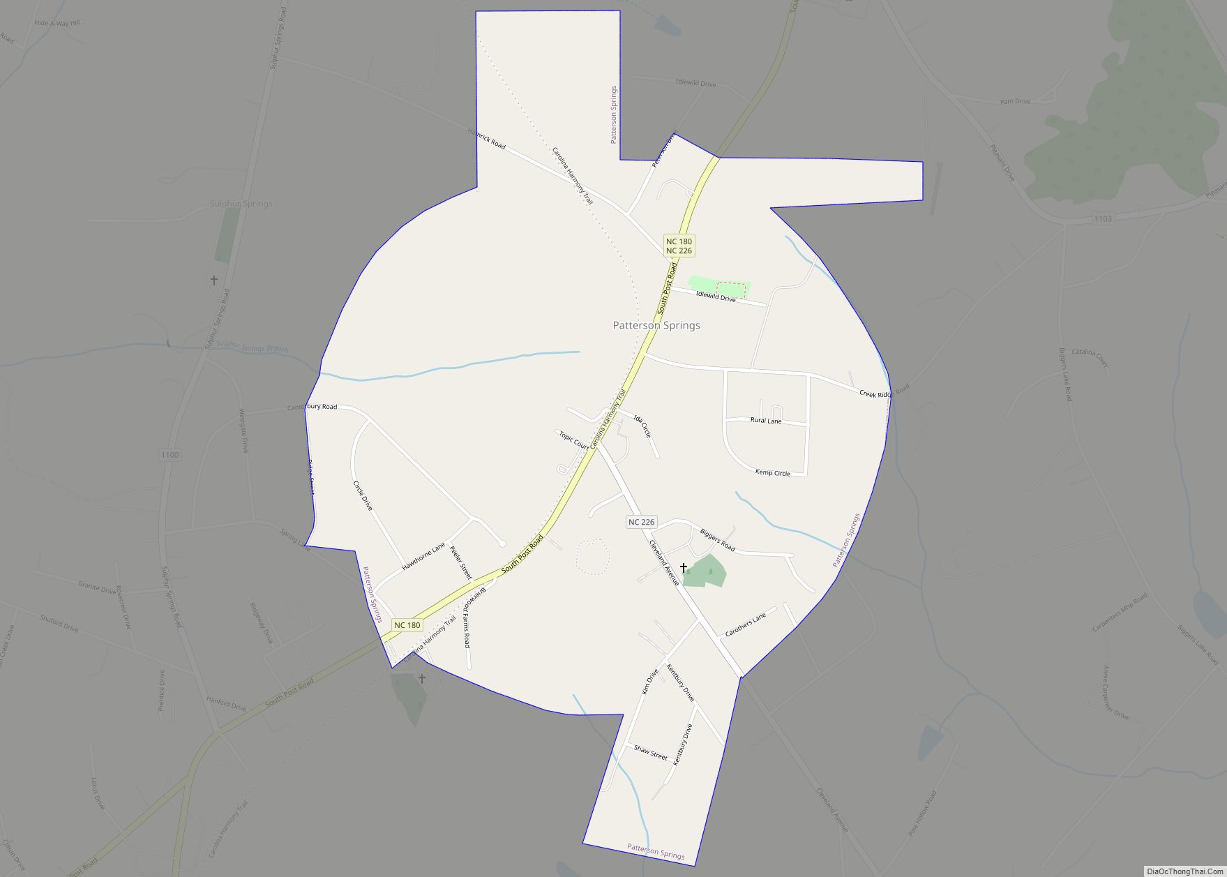
Patterson Springs is a town in Cleveland County, North Carolina, United States. The population was 622 at the 2010 census. Patterson Springs town overview: Name: Patterson Springs town LSAD Code: 43 LSAD Description: town (suffix) State: North Carolina County: Cleveland County Elevation: 919 ft (280 m) Total Area: 1.03 sq mi (2.66 km²) Land Area: 1.03 sq mi (2.66 km²) Water Area: 0.00 sq mi … Read more

Map of Pink Hill town

Map of Pink Hill town

Pink Hill is a town in Lenoir County, North Carolina, United States. The population was 552 at the 2010 census. The town was incorporated in 1915. Pink Hill town overview: Name: Pink Hill town LSAD Code: 43 LSAD Description: town (suffix) State: North Carolina County: Lenoir County Elevation: 135 ft (41 m) Total Area: 0.46 sq mi (1.20 km²) Land … Read more

Map of Piney Green CDP

Map of Piney Green CDP

Piney Green is a census-designated place (CDP) in Onslow County, North Carolina, United States. The population was 11,658 at the 2000 census. It is part of the Jacksonville, North Carolina Metropolitan Statistical Area. Piney Green CDP overview: Name: Piney Green CDP LSAD Code: 57 LSAD Description: CDP (suffix) State: North Carolina County: Onslow County Elevation: … Read more

Map of Pineville town, North Carolina

Map of Pineville town, North Carolina

Pineville (/ˈpiːnvɪl/; locally /ˈpiːnvəl/) is a suburban town in the southernmost portion of Mecklenburg County, North Carolina, United States, situated in the Waxhaws district between Charlotte and Fort Mill. Pineville town overview: Name: Pineville town LSAD Code: 43 LSAD Description: town (suffix) State: North Carolina County: Mecklenburg County Elevation: 587 ft (179 m) Total Area: 6.68 sq mi (17.29 km²) … Read more

Map of Pinetown CDP

Map of Pinetown CDP

Pinetown is an unincorporated community and census-designated place (CDP) in Beaufort County, North Carolina, United States. As of the 2010 census it had a population of 155. The community is located in northern Beaufort County in the Coastal Plain region of North Carolina. It is 14 miles (23 km) northeast of Washington, the county seat. Pinetown … Read more

Map of Pinetops town

Map of Pinetops town

Pinetops is a town in Edgecombe County, North Carolina, United States. It is part of the Rocky Mount, North Carolina Metropolitan Statistical Area. The population was 1,374 at the 2010 census. Pinetops town overview: Name: Pinetops town LSAD Code: 43 LSAD Description: town (suffix) State: North Carolina County: Edgecombe County Elevation: 102 ft (31 m) Total Area: … Read more

Map of Pinehurst village, North Carolina

Map of Pinehurst village, North Carolina

Pinehurst is a village in Moore County, North Carolina, United States. As of the 2010 census, the village population was 13,124. It is home of the historic Pinehurst Resort, a Golf resort, which has hosted multiple United States Open Championships in Golf. The village lies adjacent to the Pine Needles Lodge and Golf Club, which … Read more