Map of Wingate town, North Carolina
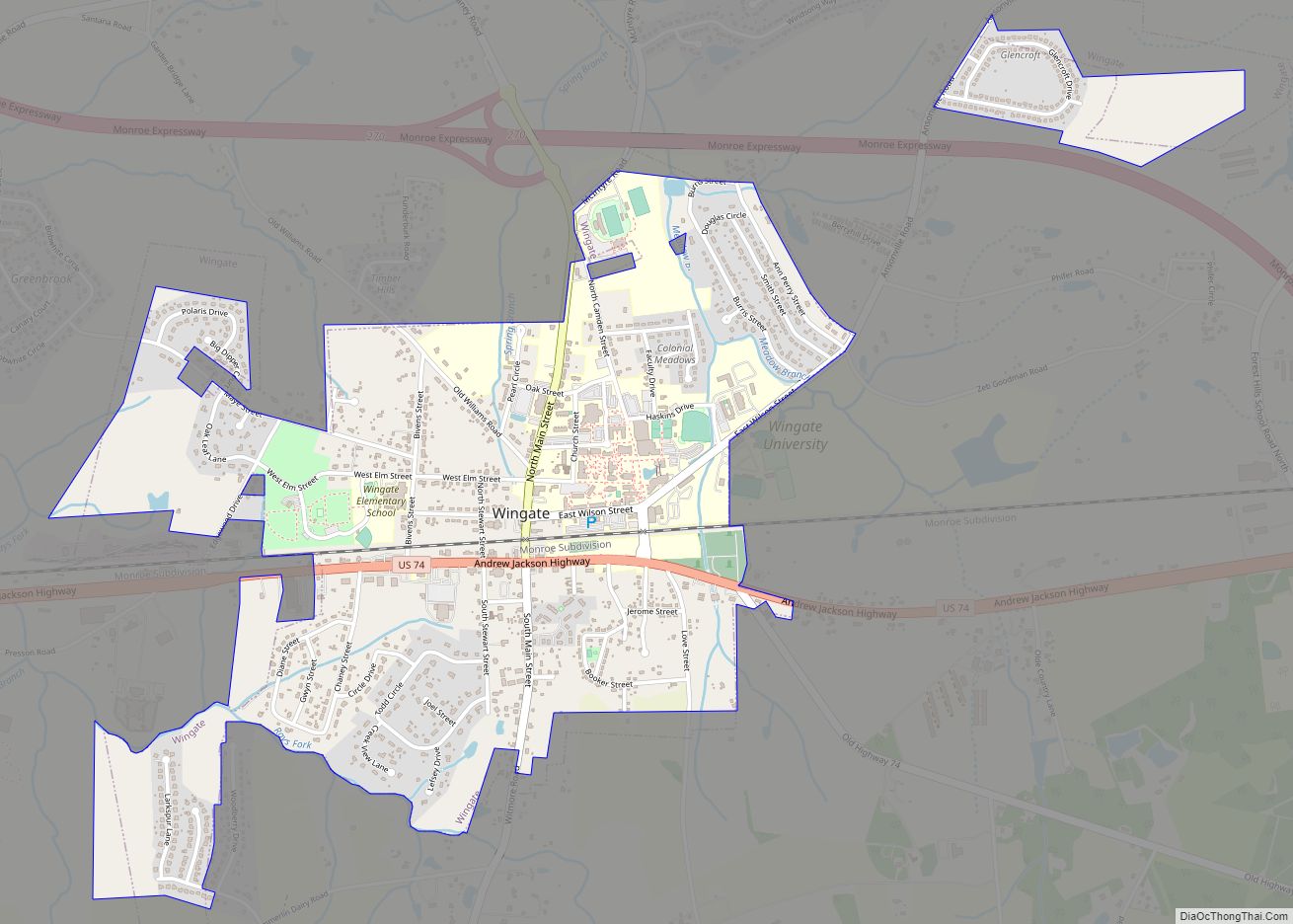
Wingate is a town in Union County, North Carolina, United States. The population was 3,491 at the 2010 census. Wingate town overview: Name: Wingate town LSAD Code: 43 LSAD Description: town (suffix) State: North Carolina County: Union County Elevation: 587 ft (179 m) Total Area: 2.25 sq mi (5.83 km²) Land Area: 2.23 sq mi (5.78 km²) Water Area: 0.02 sq mi (0.05 km²) Total Population: ... Read more
Map of Wingate town, North Carolina
Map of Winfall town
Winfall is a town in Perquimans County, North Carolina, United States. The population was 554 at the 2020 census. It is part of the Elizabeth City, North Carolina Micropolitan Statistical Area. Winfall town overview: Name: Winfall town LSAD Code: 43 LSAD Description: town (suffix) State: North Carolina County: Perquimans County Incorporated: 1887 Elevation: 13 ft (4 m) ... Read more
Map of Winfall town
Map of Windsor town, North Carolina
Windsor is a town in Bertie County, North Carolina, United States. The population was 3,630 at the 2010 census, up from 2,283 in 2000. It is the county seat of Bertie County, which is also the homeland of the Southern Band Tuscarora Tribe that remained in North Carolina post Colonialism. Windsor is located in North ... Read more
Map of Windsor town, North Carolina
Map of Wilson city, North Carolina
Wilson is a city in and the county seat of Wilson County, North Carolina, United States. Located approximately 40 mi (64 km) east of the capital city of Raleigh, it is served by the interchange of Interstate 95 and U.S. Route 264. Wilson had an estimated population of 49,459 in 2019, according to the U.S. Census Bureau, ... Read more
Map of Wilson city, North Carolina
Map of Wilson’s Mills town
Wilson’s Mills is a town in Johnston County, North Carolina, United States. In 2010, the population was 2,277, up from 1,291 in 2000. As of 2018, the estimated population was 2,689. Wilson’s Mills town overview: Name: Wilson’s Mills town LSAD Code: 43 LSAD Description: town (suffix) State: North Carolina County: Johnston County Elevation: 230 ft (70 m) ... Read more
Map of Wilson’s Mills town
Map of Williamston town, North Carolina
Williamston is a town and the county seat of Martin County, North Carolina, United States. The population was 5,511 at the 2010 census. It is located in North Carolina’s Inner Banks region. The closest major city is Greenville, approximately 28 mi to the southwest. Williamston town overview: Name: Williamston town LSAD Code: 43 LSAD Description: town ... Read more
Map of Williamston town, North Carolina
Map of Wilkesboro town
Wilkesboro is a town in and the county seat of Wilkes County, North Carolina, United States. The population was 3,687 at the 2020 census. The town is located along the south bank of the Yadkin River, directly opposite the town of North Wilkesboro. Wilkesboro is a Small Town Main Street community and has recently revitalized ... Read more
Map of Wilkesboro town
Map of Whitsett town
Whitsett is a town in Guilford County, North Carolina, United States. The population was 590 at the 2010 census. Whitsett town overview: Name: Whitsett town LSAD Code: 43 LSAD Description: town (suffix) State: North Carolina County: Guilford County Elevation: 686 ft (209 m) Total Area: 2.61 sq mi (6.76 km²) Land Area: 2.58 sq mi (6.69 km²) Water Area: 0.03 sq mi (0.07 km²) Total Population: ... Read more
Map of Whitsett town
Map of Woodland town, North Carolina
Woodland is a town in Northampton County, North Carolina, United States. The population was 809 at the 2010 census. It is part of the Roanoke Rapids, North Carolina Micropolitan Statistical Area. Woodland town overview: Name: Woodland town LSAD Code: 43 LSAD Description: town (suffix) State: North Carolina County: Northampton County Elevation: 69 ft (21 m) Total Area: ... Read more
Map of Woodland town, North Carolina
Map of Woodfin town
Woodfin is a town in Buncombe County, North Carolina, United States. The population was 6,123 as of the 2010 census. It is part of the Asheville Metropolitan Statistical Area. The town is named for Nicholas Washington Woodfin, a renowned lawyer and statesman of early North Carolina, under whom Governor Zebulon Vance clerked as an attorney. ... Read more
Map of Woodfin town
Map of Zebulon town, North Carolina
Zebulon town overview: Name: Zebulon town LSAD Code: 43 LSAD Description: town (suffix) State: North Carolina County: Johnston County, Wake County FIPS code: 3776220 Online Interactive Map Zebulon online map. Source: Basemap layers from Google Map, Open Street Map (OSM), Arcgisonline, Wmflabs. Boundary Data from Database of Global Administrative Areas. Zebulon location map. Where is ... Read more
Map of Zebulon town, North Carolina
Map of Youngsville town, North Carolina
Youngsville is a town in Franklin County, North Carolina, United States. The population was 2,016 at the 2020 census. Youngsville town overview: Name: Youngsville town LSAD Code: 43 LSAD Description: town (suffix) State: North Carolina County: Franklin County Incorporated: March 17, 1875 Elevation: 462 ft (141 m) Total Area: 1.86 sq mi (4.82 km²) Land Area: 1.85 sq mi (4.80 km²) Water Area: ... Read more
Map of Youngsville town, North Carolina