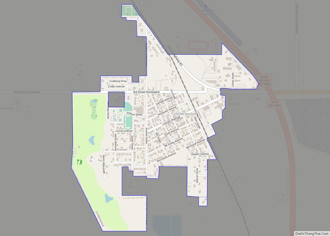
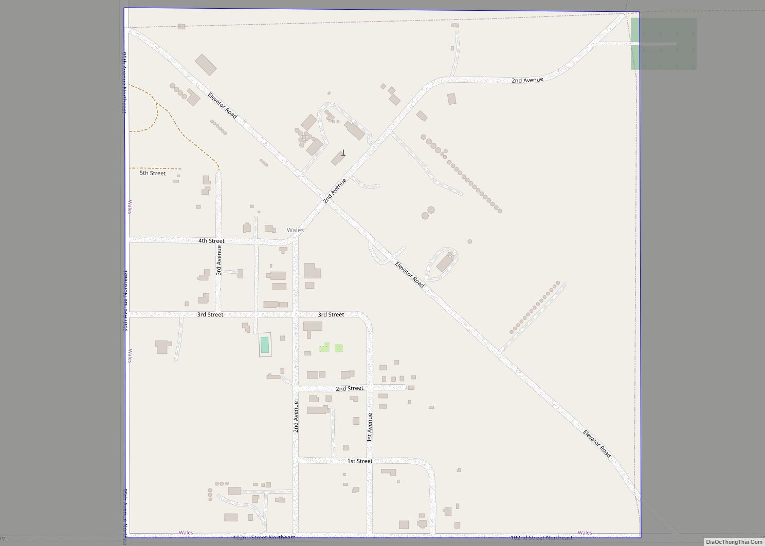
Map of Verona city, North Dakota
Verona is a city in LaMoure County, North Dakota, United States. The population was 59 at the 2020 census. Verona was founded in 1886. Verona city overview: Name: Verona city LSAD Code: 25 LSAD Description: city (suffix) State: North Dakota County: LaMoure County Founded: 1886 Elevation: 1,388 ft (423 m) Total Area: 0.57 sq mi (1.49 km²) Land Area: 0.57 sq mi ... Read more
Map of Verona city, North Dakota
Map of Venturia city
Venturia is a city in McIntosh County, North Dakota, United States. The population was 21 at the 2020 census. Venturia was founded in 1901. Venturia city overview: Name: Venturia city LSAD Code: 25 LSAD Description: city (suffix) State: North Dakota County: McIntosh County Founded: 1901 Elevation: 2,073 ft (632 m) Total Area: 0.11 sq mi (0.29 km²) Land Area: 0.11 sq mi ... Read more
Map of Venturia city
Map of Velva city
Velva is a city in McHenry County, North Dakota, United States. Part of the Minot Micropolitan Statistical Area, it was founded in 1897 and the population was 1,086 at the 2020 census. Southeast of Minot, Velva is at the southernmost point of the Souris River. Velva city overview: Name: Velva city LSAD Code: 25 LSAD Description: ... Read more
Map of Velva city
Map of Valley City, North Dakota
Valley City is a city in Barnes County, North Dakota, United States. It is the county seat of Barnes County. The population was 6,575 during the 2020 census, making it the 12th largest city in North Dakota. Valley City was founded in 1874. Valley City is known for its many bridges over the Sheyenne River, ... Read more
Map of Valley City, North Dakota
Map of White Earth city, North Dakota
White Earth is one of the oldest cities in Mountrail County, North Dakota, United States. The population was 100 at the 2020 census. White Earth township was founded in 1887. The community’s recent growth due to the North Dakota oil boom is the subject of an Academy Award–nominated short documentary film, White Earth. White Earth ... Read more
Map of White Earth city, North Dakota
Map of Wheatland CDP, North Dakota
Wheatland is a census-designated place (CDP) in Cass County, North Dakota, United States. The population was 68 at the 2010 census. Wheatland CDP overview: Name: Wheatland CDP LSAD Code: 57 LSAD Description: CDP (suffix) State: North Dakota County: Cass County Total Area: 4.01 sq mi (10.39 km²) Land Area: 4.01 sq mi (10.39 km²) Water Area: 0.00 sq mi (0.00 km²) Total Population: 92 ... Read more
Map of Wheatland CDP, North Dakota
Map of Westhope city
Westhope is a city in Bottineau County, North Dakota, United States. The population was 374 at the 2020 census. Westhope was founded in 1903 along a Great Northern Railway branch line that began in Rugby. The name was based on the slogan “Hope of the West,” created by Great Northern officials to promote prosperity for ... Read more
Map of Westhope city
Map of Watford City
Watford City (Hidatsa: abaʔaruʔush), founded in 1914, is a city in and the county seat of McKenzie County, North Dakota, United States. The population was 6,207 at the 2020 census, making it the thirteenth largest city in North Dakota. Because Watford City is part of the Bakken field, the North Dakota oil boom has significantly ... Read more
Map of Watford City
Map of Washburn city, North Dakota
Washburn is a city in southern McLean County, North Dakota, United States. Located along the upper Missouri River, it is the county seat of McLean County. The population was 1,300 at the 2020 census. Washburn was founded in 1882 near the former site of Fort Mandan, winter quarters of the Lewis and Clark Expedition in ... Read more
Map of Washburn city, North Dakota
Map of Warwick city, North Dakota
Warwick is a city in Benson County, North Dakota, United States. The population was 55 at the 2020 census. Warwick was founded in 1907. Warwick city overview: Name: Warwick city LSAD Code: 25 LSAD Description: city (suffix) State: North Dakota County: Benson County Founded: 1907 Elevation: 1,476 ft (450 m) Total Area: 1.00 sq mi (2.60 km²) Land Area: 0.65 sq mi ... Read more
Map of Warwick city, North Dakota
Map of Walhalla city, North Dakota
Walhalla is a city in Pembina County, North Dakota, United States. It sits on the banks of the Pembina River, five miles (8 km) from the border with Manitoba (Canada) and approximately 45 mi (72 km) from the border with Minnesota. The population was 893 at the 2020 census. Walhalla city overview: Name: Walhalla city LSAD Code: ... Read more
Map of Walhalla city, North Dakota
Map of Wales city, North Dakota
Wales is a city in Cavalier County, North Dakota, United States. The population was 10 at the 2020 census. Wales was founded in 1897. Gavilon is Wales’ largest employer. Wales city overview: Name: Wales city LSAD Code: 25 LSAD Description: city (suffix) State: North Dakota County: Cavalier County Founded: 1897 Elevation: 1,568 ft (478 m) Total Area: ... Read more
Map of Wales city, North Dakota