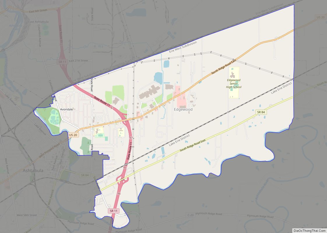
Map of Edgerton village, Ohio

Map of Edgerton village, Ohio

Edgerton is a village in Williams County, Ohio, United States in the extreme northwest corner of the state. The population was 2,012 at the 2010 census. Edgerton village overview: Name: Edgerton village LSAD Code: 47 LSAD Description: village (suffix) State: Ohio County: Williams County Elevation: 840 ft (256 m) Total Area: 1.72 sq mi (4.46 km²) Land Area: 1.71 sq mi (4.44 km²) … Read more

Map of Etna CDP, Ohio

Map of Etna CDP, Ohio

Etna (formerly Carthage) is an unincorporated community and census-designated place (CDP) in Licking County, Ohio, United States. As of the 2010 census it had a population of 1,215. It lies at an elevation of 1,069 feet (326 m) at the intersection of U.S. Route 40 and State Route 310. It was listed as a census-designated place … Read more

Map of Enon village

Map of Enon village, Ohio

Enon is a village in Clark County, Ohio, United States. The population was 2,455 at the 2020 census. It is part of the Springfield, Ohio Metropolitan Statistical Area. Enon is the headquarters of the Speedway gas station chain. Enon village overview: Name: Enon village LSAD Code: 47 LSAD Description: village (suffix) State: Ohio County: Clark … Read more

Map of Englewood city, Ohio

Map of Englewood city, Ohio

Englewood is a city in Montgomery County, Ohio, and a northern suburb of Dayton. The population was 13,463 at the 2020 census. It is part of the Dayton metropolitan area. Englewood city overview: Name: Englewood city LSAD Code: 25 LSAD Description: city (suffix) State: Ohio County: Montgomery County Founded: May 6, 1841 (as Harrisburg) Incorporated: … Read more

Map of Empire village, Ohio

Map of Empire village, Ohio

Empire is a village in northeastern Jefferson County, Ohio, United States, along the Ohio River. The population was 232 at the 2020 census. It is part of the Weirton–Steubenville metropolitan area. Empire village overview: Name: Empire village LSAD Code: 47 LSAD Description: village (suffix) State: Ohio County: Jefferson County Elevation: 682 ft (208 m) Total Area: 0.30 sq mi … Read more

Map of Elyria city, Ohio

Map of Elyria city, Ohio

Elyria (/əˈlɪəriə/ ə-LEER-ee-ə) is a city in and the county seat of Lorain County, Ohio, United States, located at the forks of the Black River in Northeast Ohio 23 miles (37 km) southwest of Cleveland. As of the 2020 census, the city had a population of 52,656. It is a principal city in the Cleveland metropolitan … Read more

Map of Fairfield Beach CDP

Map of Fairfield Beach CDP

Fairfield Beach is an unincorporated community and census-designated place (CDP) in Fairfield County, Ohio, United States. The population was 1,292 at the 2010 census. Fairfield Beach CDP overview: Name: Fairfield Beach CDP LSAD Code: 57 LSAD Description: CDP (suffix) State: Ohio County: Fairfield County Elevation: 928 ft (283 m) Total Area: 0.98 sq mi (2.53 km²) Land Area: 0.66 sq mi (1.70 km²) … Read more

Map of Fairfax village, Ohio

Map of Fairfax village, Ohio

Fairfax is a village in Hamilton County, Ohio, United States. It is a suburb of Cincinnati. The population was 1,768 at the 2020 census. Fairfax village overview: Name: Fairfax village LSAD Code: 47 LSAD Description: village (suffix) State: Ohio County: Hamilton County Incorporated: 1955 Elevation: 564 ft (172 m) Total Area: 0.78 sq mi (2.02 km²) Land Area: 0.78 sq mi (2.02 km²) … Read more

Map of Fairborn city

Map of Fairborn city

Fairborn is a city in Greene County, Ohio, United States. The population was 34,620 at the 2020 census. Fairborn is a suburb of Dayton, and part of the Dayton Metropolitan Statistical Area. It is the only city in the world named Fairborn, a portmanteau created from the names Fairfield and Osborn. After the Great Dayton … Read more

Map of Evendale village

Map of Evendale village

Evendale (pronounced /ˈiːvəndeɪl/ EE-vən-dayl) is a village in Hamilton County, Ohio, United States, within the Cincinnati metropolitan area. The population was 2,669 at the 2020 census. Evendale village overview: Name: Evendale village LSAD Code: 47 LSAD Description: village (suffix) State: Ohio County: Hamilton County Elevation: 594 ft (181 m) Total Area: 4.77 sq mi (12.35 km²) Land Area: 4.77 sq mi (12.35 km²) … Read more

Map of Euclid city

Map of Euclid city

Euclid is a city in Cuyahoga County, Ohio, United States. It is an inner ring suburb of Cleveland. The population was 49,692 at the 2020 census, making it the fourth largest city in Cuyahoga County, behind Cleveland, Parma and Lakewood. Euclid city overview: Name: Euclid city LSAD Code: 25 LSAD Description: city (suffix) State: Ohio … Read more

Map of Findlay city, Ohio

Map of Findlay city, Ohio

Findlay (/ˈfɪnli/ FIN-lee) is a city in and the county seat of Hancock County, Ohio, United States. The second-largest city in Northwest Ohio, Findlay lies about 40 miles (64 km) south of Toledo. Its population was 40,313 at the 2020 census. The principal city of the Findlay micropolitan area, it is home to the University of … Read more