Map of Loveland city, Ohio

Map of Loveland city, Ohio

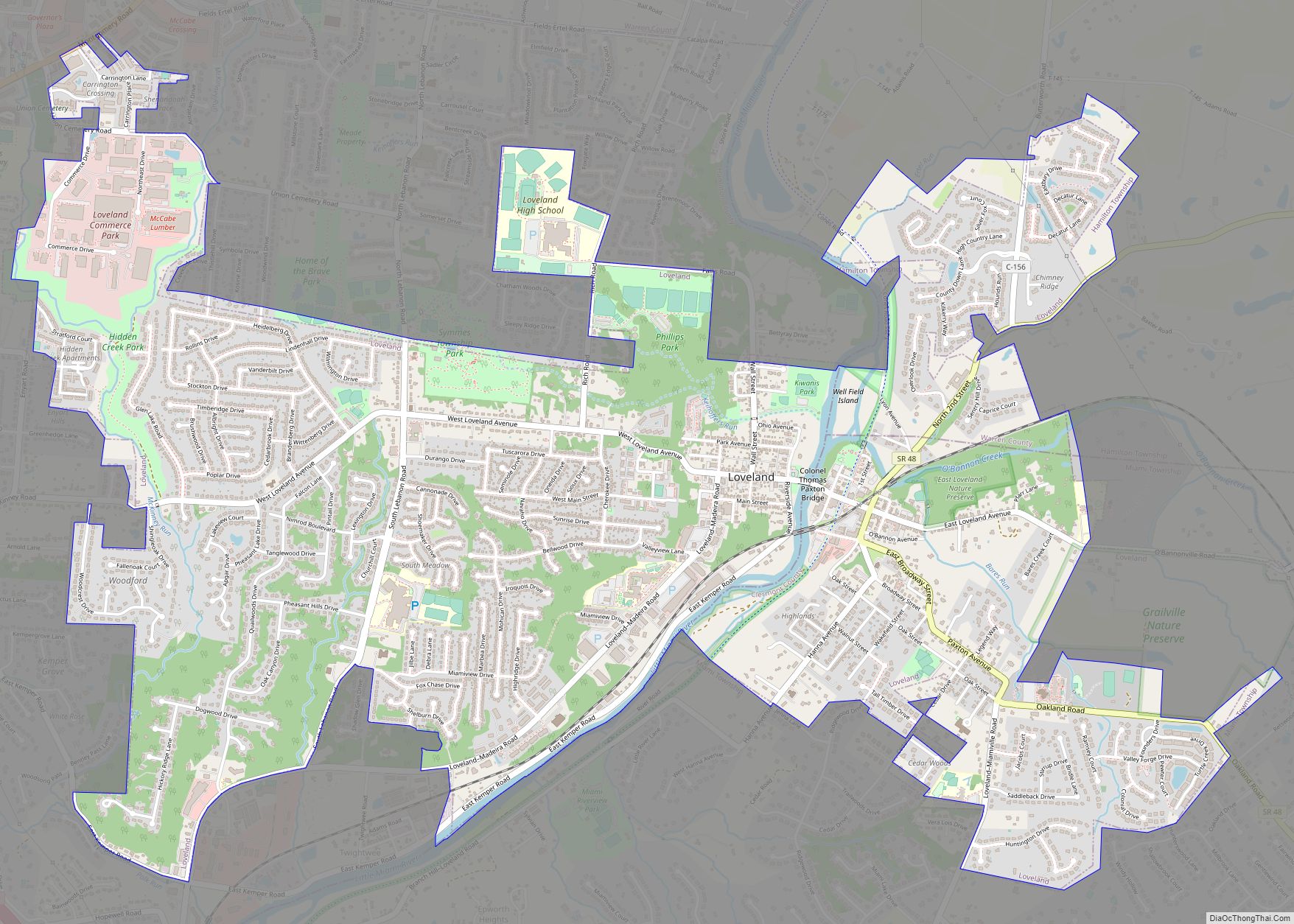
Loveland is a city in Hamilton, Clermont, and Warren counties in the southwestern part of the U.S. state of Ohio. The population was 13,307 at the 2020 census. Considered part of the Cincinnati metropolitan area, Loveland is located near exit 52 off Interstate 275, about 15 miles (24 km) northeast of the Cincinnati city limits. It … Read more

Map of Loveland Park CDP

Map of Loveland Park CDP

Loveland Park is a census-designated place (CDP) located in Symmes Township, Hamilton County and Deerfield Township, Warren County, in the southwestern part of the U.S. state of Ohio. The CDP is named after the city of Loveland. The population was 1,737 at the 2020 census. Loveland Park CDP overview: Name: Loveland Park CDP LSAD Code: … Read more

Map of Louisville city, Ohio

Map of Louisville city, Ohio

Louisville (/ˈluːɪsvɪl/) is a city in Stark County, Ohio, United States. The population was 9,521 at the time of the 2020 census. Located 7 miles (11 km) northeast of Canton, it is a suburb of the Canton–Massillon metropolitan area. Louisville city overview: Name: Louisville city LSAD Code: 25 LSAD Description: city (suffix) State: Ohio County: Stark … Read more

Map of Loudonville village

Map of Loudonville village

Loudonville is a village in Ashland and Holmes counties in the U.S. state of Ohio. The population was 2,786 at the 2020 census. Loudonville is nicknamed the “Canoe Capital of Ohio” for the many canoe liveries along the Mohican River. It is also home to Mohican State Park and Mohican-Memorial State Forest and Landoll’s Mohican … Read more

Map of Lore City village

Map of Lore City village

Lore City is a village in Guernsey County, Ohio, United States. The population was 325 at the 2010 census. Lore City village overview: Name: Lore City village LSAD Code: 47 LSAD Description: village (suffix) State: Ohio County: Guernsey County Elevation: 820 ft (250 m) Total Area: 0.33 sq mi (0.85 km²) Land Area: 0.33 sq mi (0.85 km²) Water Area: 0.00 sq mi (0.00 km²) Total … Read more

Map of Lordstown village

Map of Lordstown village

Lordstown is a village in southern Trumbull County, Ohio, United States. The population was 3,332 at the 2020 census. It is part of the Youngstown–Warren metropolitan area. Lordstown is best known as the home of the Lordstown Assembly, a General Motors automotive plant that produced compact cars from 1966 until 2019. After the closure of … Read more

Map of Lorain city

Map of Lorain city, Ohio

Lorain (/lɔːˈreɪn/) is a city in Lorain County, Ohio, United States. It is located in Northeast Ohio on Lake Erie at the mouth of the Black River, about 25 miles (40 km) miles west of Cleveland. As of the 2020 census, the city had a population of 65,211, making it Ohio’s ninth-largest city, the third-largest in … Read more

Map of Lucasville CDP

Map of Lucasville CDP

Lucasville is a census-designated place (CDP) in Scioto County, Ohio, United States. The population was 1,655 at the 2020 census. It is part of the Portsmouth micropolitan area. Lucasville is the location of the Scioto County Fairgrounds. The Southern Ohio Correctional Facility, Ohio’s one of three maximum security prisons and the location of Ohio’s death … Read more

Map of Lucas village, Ohio

Map of Lucas village, Ohio

Lucas is a village in southeastern Richland County, Ohio, United States. Lucas is part of the Mansfield, Ohio Metropolitan Statistical Area. Lucas village overview: Name: Lucas village LSAD Code: 47 LSAD Description: village (suffix) State: Ohio County: Richland County Elevation: 1,093 ft (333 m) Total Area: 0.68 sq mi (1.76 km²) Land Area: 0.68 sq mi (1.75 km²) Water Area: 0.00 sq mi (0.00 km²) Total … Read more

Map of Macksburg village, Ohio

Map of Macksburg village, Ohio

Macksburg is a village in Washington County, Ohio, United States, along the West Fork of Duck Creek. The population was 120 at the 2020 census. The village is about 28 miles (45 km) south of Cambridge, Ohio. Macksburg village overview: Name: Macksburg village LSAD Code: 47 LSAD Description: village (suffix) State: Ohio County: Washington County Elevation: … Read more

Map of Mack CDP

Map of Mack CDP

Mack is a census-designated place (CDP) in Green and Miami townships, Hamilton County, Ohio, United States. The population was 11,088 at the 2020 census. At prior censuses, the community was listed as two separate CDPs, Mack North and Mack South. Mack CDP overview: Name: Mack CDP LSAD Code: 57 LSAD Description: CDP (suffix) State: Ohio … Read more

Map of Macedonia city, Ohio

Map of Macedonia city, Ohio

Macedonia is a city in northern Summit County, Ohio, United States. The population was 12,168 at the 2020 census. It is a suburb of the Akron metropolitan area. Macedonia city overview: Name: Macedonia city LSAD Code: 25 LSAD Description: city (suffix) State: Ohio County: Summit County Elevation: 988 ft (301 m) Total Area: 9.76 sq mi (25.29 km²) Land Area: … Read more