Murray City is a village in Hocking County, Ohio, United States. The population was 449 at the 2010 census. Murray City village overview: Name: Murray City village LSAD Code: 47 LSAD Description: village (suffix) State: Ohio County: Hocking County Elevation: 709 ft (216 m) Total Area: 0.32 sq mi (0.82 km²) Land Area: 0.32 sq mi (0.82 km²) Water Area: 0.00 sq mi (0.00 km²) Total ... Read more
Ohio Cities and Places
Munroe Falls is a city in east-central Summit County, Ohio, United States, along the Cuyahoga River. The population was 5,044 at the 2020 census. It is a suburb of Akron and is part of the Akron metropolitan area. Munroe Falls city overview: Name: Munroe Falls city LSAD Code: 25 LSAD Description: city (suffix) State: Ohio ... Read more
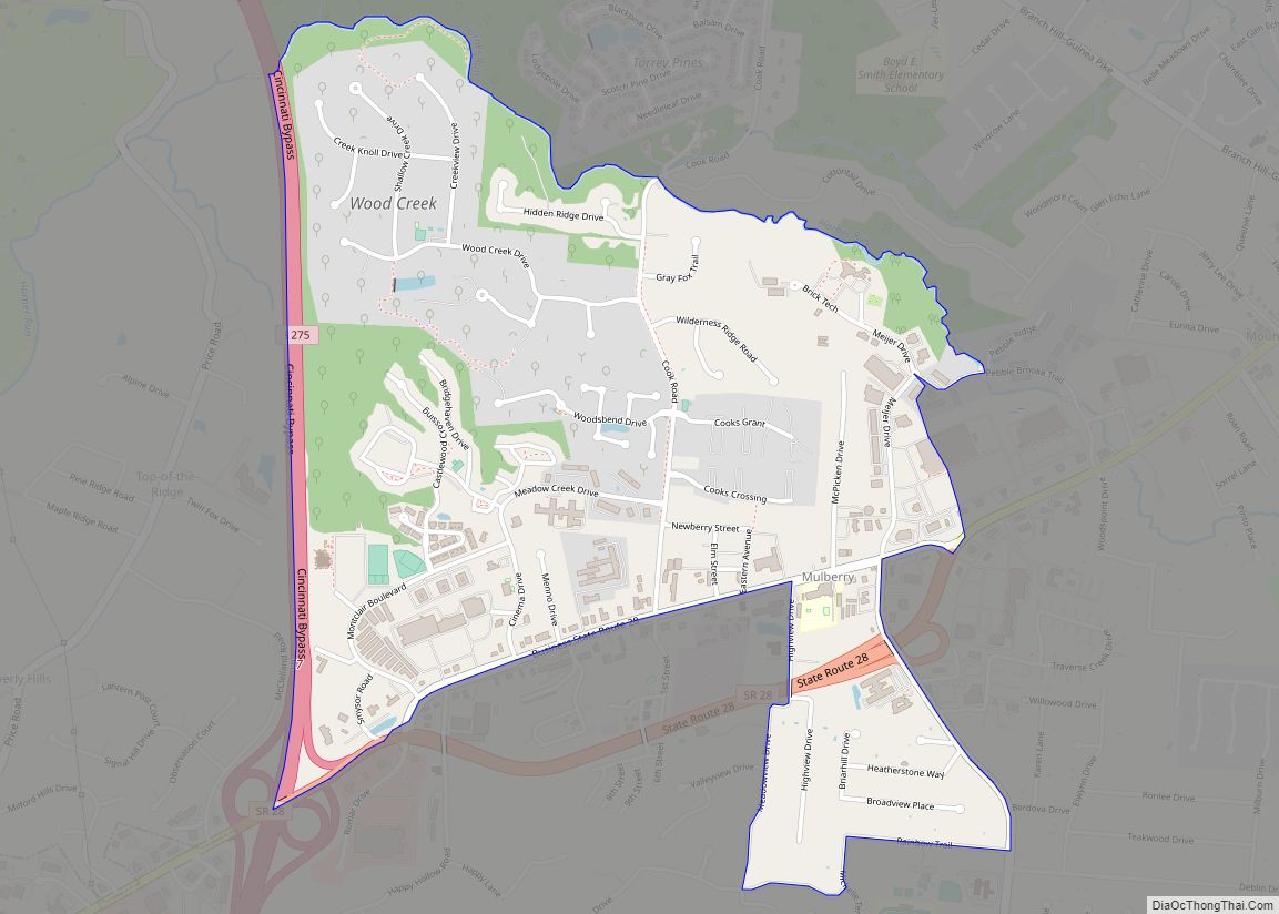
Mulberry is a census-designated place (CDP) in Miami Township, Clermont County, Ohio, United States. The population was 3,459 at the 2020 census. Mulberry CDP overview: Name: Mulberry CDP LSAD Code: 57 LSAD Description: CDP (suffix) State: Ohio County: Clermont County Elevation: 840 ft (256 m) Total Area: 1.60 sq mi (4.15 km²) Land Area: 1.60 sq mi (4.15 km²) Water Area: 0.00 sq mi (0.00 km²) ... Read more
Mowrystown is a village in Highland County, Ohio, United States. The population was 360 at the 2010 census. Mowrystown village overview: Name: Mowrystown village LSAD Code: 47 LSAD Description: village (suffix) State: Ohio County: Highland County Elevation: 997 ft (304 m) Total Area: 0.49 sq mi (1.27 km²) Land Area: 0.48 sq mi (1.25 km²) Water Area: 0.01 sq mi (0.02 km²) Total Population: 385 Population ... Read more
Mount Victory is a village in Hardin County, Ohio, United States. The population was 627 at the 2010 census. It is home to a quaint downtown main street along busy State Route 31 between Marysville and Kenton, and to a volunteer fire department. Mount Victory village overview: Name: Mount Victory village LSAD Code: 47 LSAD ... Read more
Nevada (/nəˈveɪdə/ nə-VAY-də) is a village in Wyandot County, Ohio, United States. The population was 760 at the 2010 census. Nevada village overview: Name: Nevada village LSAD Code: 47 LSAD Description: village (suffix) State: Ohio County: Wyandot County Elevation: 928 ft (283 m) Total Area: 1.03 sq mi (2.66 km²) Land Area: 1.03 sq mi (2.66 km²) Water Area: 0.00 sq mi (0.00 km²) Total Population: ... Read more
Nettle Lake CDP overview: Name: Nettle Lake CDP LSAD Code: 57 LSAD Description: CDP (suffix) State: Ohio FIPS code: 3953914 Online Interactive Map Nettle Lake online map. Source: Basemap layers from Google Map, Open Street Map (OSM), Arcgisonline, Wmflabs. Boundary Data from Database of Global Administrative Areas. Nettle Lake location map. Where is Nettle Lake ... Read more
Nelsonville is a city in northwestern Athens County, Ohio, United States, located about 60 miles (97 km) southeast of Columbus. The population was 5,373 at the 2020 census. It is home to Hocking College as well as Rocky Brands. Nelsonville is surrounded by Ohio’s only national forest, the Wayne National Forest. Nelsonville city overview: Name: Nelsonville ... Read more
Nellie is a village in Coshocton County, Ohio, United States, along the Walhonding River. The population was 131 at the 2010 census. The 1930s-era Mohawk Dam, a dry dam built for flood control, is just to the north and west of the village. Nellie village overview: Name: Nellie village LSAD Code: 47 LSAD Description: village ... Read more
Negley is an unincorporated community and census-designated place in Middleton Township, Columbiana County, Ohio, United States. The population was 274 at the 2020 census. It is part of the Salem micropolitan area, 22 miles (35 km) south of Youngstown. Historically a mining community, Negley lies at the confluence of Bull Creek and the North Fork of ... Read more
Neffs is an unincorporated community and census-designated place in northwestern Pultney Township, Belmont County, Ohio, United States. The population was 878 at the 2020 census. It is part of the Wheeling metropolitan area. Neffs CDP overview: Name: Neffs CDP LSAD Code: 57 LSAD Description: CDP (suffix) State: Ohio County: Belmont County Elevation: 735 ft (224 m) Total ... Read more
Neapolis is a census-designated place (CDP) in northwestern Providence Township, Lucas County, Ohio, United States. As of the 2020 Census it had a population of 680. It has a post office, with the ZIP code of 43547. Neapolis CDP overview: Name: Neapolis CDP LSAD Code: 57 LSAD Description: CDP (suffix) State: Ohio County: Lucas County ... Read more