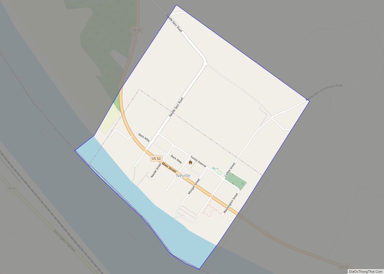
Map of Negley CDP
Negley is an unincorporated community and census-designated place in Middleton Township, Columbiana County, Ohio, United States. The population was 274 at the 2020 census. It is part of the Salem micropolitan area, 22 miles (35 km) south of Youngstown. Historically a mining community, Negley lies at the confluence of Bull Creek and the North Fork of ... Read more
Map of Negley CDP
Map of Neffs CDP
Neffs is an unincorporated community and census-designated place in northwestern Pultney Township, Belmont County, Ohio, United States. The population was 878 at the 2020 census. It is part of the Wheeling metropolitan area. Neffs CDP overview: Name: Neffs CDP LSAD Code: 57 LSAD Description: CDP (suffix) State: Ohio County: Belmont County Elevation: 735 ft (224 m) Total ... Read more
Map of Neffs CDP
Map of Neapolis CDP
Neapolis is a census-designated place (CDP) in northwestern Providence Township, Lucas County, Ohio, United States. As of the 2020 Census it had a population of 680. It has a post office, with the ZIP code of 43547. Neapolis CDP overview: Name: Neapolis CDP LSAD Code: 57 LSAD Description: CDP (suffix) State: Ohio County: Lucas County ... Read more
Map of Neapolis CDP
Map of New Bremen village
New Bremen (/ˈbriːmʌn/) is a village in Auglaize County, Ohio, United States. The population was 2,978 at the 2010 census. It is included in the Wapakoneta, Ohio Micropolitan Statistical Area. The village is adjacent to Minster to the south. The village was founded by German immigrants in 1832 and is named after Bremen. It is ... Read more
Map of New Bremen village
Map of New Boston village, Ohio
New Boston is a village in Scioto County, Ohio, United States, along the Ohio River. The population was 2,272 at the 2010 census. Apart from its southern boundary on the Ohio River, New Boston is entirely surrounded by the city of Portsmouth. New Boston is served by the Portsmouth Public Library and the New Boston ... Read more
Map of New Boston village, Ohio
Map of New Bloomington village
New Bloomington is a village in Marion County, Ohio, United States. The population was 515 at the 2010 census. New Bloomington is served by Elgin Local School District. New Bloomington was originally named Carey Station, and under the latter name was laid out in 1856. New Bloomington village overview: Name: New Bloomington village LSAD Code: ... Read more
Map of New Bloomington village
Map of New Bavaria village
New Bavaria is a village in Henry County, Ohio, United States. The population was 86 at the 2020 census. New Bavaria village overview: Name: New Bavaria village LSAD Code: 47 LSAD Description: village (suffix) State: Ohio County: Henry County Elevation: 735 ft (224 m) Total Area: 0.07 sq mi (0.18 km²) Land Area: 0.07 sq mi (0.18 km²) Water Area: 0.00 sq mi (0.00 km²) Total ... Read more
Map of New Bavaria village
Map of New Baltimore CDP, Ohio
New Baltimore is a census-designated place (CDP) in Crosby Township, Hamilton County, Ohio. The population was 1,596 in the 2020 census. New Baltimore CDP overview: Name: New Baltimore CDP LSAD Code: 57 LSAD Description: CDP (suffix) State: Ohio County: Hamilton County Elevation: 550 ft (170 m) Total Area: 1.39 sq mi (3.60 km²) Land Area: 1.37 sq mi (3.56 km²) Water Area: 0.02 sq mi ... Read more
Map of New Baltimore CDP, Ohio
Map of New Athens village, Ohio
New Athens (/ˈeɪθɛnz/ AYTH-inz) is a village in Harrison County, Ohio, United States. The population was 222 at the 2020 census. New Athens village overview: Name: New Athens village LSAD Code: 47 LSAD Description: village (suffix) State: Ohio County: Harrison County Elevation: 1,184 ft (361 m) Total Area: 0.29 sq mi (0.75 km²) Land Area: 0.29 sq mi (0.75 km²) Water Area: 0.00 sq mi ... Read more
Map of New Athens village, Ohio
Map of New Alexandria village, Ohio
New Alexandria is a village in eastern Jefferson County, Ohio, United States. The population was 232 at the 2020 census. It is part of the Weirton–Steubenville metropolitan area. New Alexandria village overview: Name: New Alexandria village LSAD Code: 47 LSAD Description: village (suffix) State: Ohio County: Jefferson County Elevation: 1,224 ft (373 m) Total Area: 0.37 sq mi (0.95 km²) ... Read more
Map of New Alexandria village, Ohio
Map of New Albany city, Ohio
New Albany is a city in the U.S. state of Ohio, located 15 miles (24 km) northeast of the state capital of Columbus. Most of the city is located in Franklin County and a small portion extends into adjacent Licking County. New Albany had a population of 10,825 at the 2020 census. Founded in 1837, it ... Read more
Map of New Albany city, Ohio
Map of New California CDP
New California is a census-designated place in central Jerome Township, Union County, Ohio, United States. It is located at 40°09′22″N 83°14′12″W / 40.15611°N 83.23667°W / 40.15611; -83.23667Coordinates: 40°09′22″N 83°14′12″W / 40.15611°N 83.23667°W / 40.15611; -83.23667, at the intersection of U.S. Route 42 and Industrial Parkway, just south of 42’s intersection with U.S. Route 33. New ... Read more
Map of New California CDP